
Rheingau-Taunus district
| coat of arms | Germany map |
|---|---|

|

Coordinates: 50 ° 9 ′ N , 8 ° 4 ′ E |
| Basic data | |
| Existing period: | 1977– |
| State : | Hesse |
| Administrative region : | Darmstadt |
| Administrative headquarters : | Bad Schwalbach |
| Area : | 811.48 km 2 |
| Residents: | 187,160 (Dec. 31, 2019) |
| Population density : | 231 inhabitants per km 2 |
| License plate : | RÜD, SWA |
| Circle key : | 06 4 39 |
| NUTS : | DE71D |
| Circle structure: | 17 municipalities |
| Address of the district administration: |
Heimbacher Strasse 7 65307 Bad Schwalbach |
| Website : | |
| District Administrator : | Frank Kilian ( independent ) |
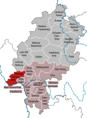
| Location of the Rheingau-Taunus district in Hesse | |
  |
|

The Rheingau-Taunus-Kreis is a regional authority in the Darmstadt administrative district in Hesse . The district town is Bad Schwalbach , the two administrative branches are in Rüdesheim am Rhein and Idstein .
The district was created in 1977 from a merger of the Rheingaukreis and Untertaunuskreis . A special feature is that the district town of Bad Schwalbach is only the seventh largest municipality in the district in terms of residents. The most populous city in the Rheingau-Taunus district is Taunusstein .
geography
location
The district surrounds the western half of the Taunushauptkamm , with the former district of Untertaunus extending north of Wiesbaden in the western Hintertaunus . On the eastern edge of the district, already near the Großer Feldberg , lies the 629.3 m above sea level. NHN high Windhain as the highest point. Southwest of the Untertaunus and beyond the deeply cut Walluftal , the Rheingau is grouped to the north and south around the Rheingau mountains with settlement focus and vineyards near the banks of the Rhine and in the Taunus foreland. To the north of it, in the Rheingau Mountains and the Wispertaunus, there are extensive forest areas, which are among the largest in Hesse. The Rhine forms the southern and southwestern district and state borders. The westernmost part of the district is part of the Upper Middle Rhine Valley Cultural Landscape World Heritage .
Land use
The district area covers a total of 81,148 hectares.
| Area type | Area in hectares |
Share in percent |
|---|---|---|
| Building and open space | 4,442 | 5.5 |
| Operating area | 183 | 0.2 |
| Recreation area | 774 | 1.0 |
| traffic area | 5,229 | 6.4 |
| Agricultural area | 23,545 | 29.0 |
| Forest area | 45.221 | 55.7 |
| Water surface | 1,454 | 1.8 |
| Area of other use | 309 | 0.4 |
As a type of use, the forest area reaches 55.7 percent, a proportion that is well above average in Hessen. The size of the water surface is remarkable and, at almost 15 square kilometers, exceeds the area of the Edersee by almost 30 percent. This wealth of water is due to the portion of the Rheingau-Taunus-Kreis on the Inselrhein , which reaches a width of 1000 meters in places at the height of the Rheingau. The district boundary lies in the middle of the historical main fairway.
Neighboring areas
Neighboring areas are the districts of Limburg-Weilburg , Hochtaunuskreis and Main-Taunus-Kreis and the independent city of Wiesbaden (all in Hesse), starting clockwise in the north . In the south and southwest, the Rhine forms the natural border with the state of Rhineland-Palatinate . There is the Mainz-Bingen district to the left of the Rhine . In the northwest it borders on the Rhein-Lahn district in Rhineland-Palatinate .
history
The formerly Franconian Rheingau belonged to the ore monastery of Mainz from 983 to 1803 and then came to the Duchy of Nassau . The Untertaunus belonged west of the Aar to the Niedergrafschaft Katzenelnbogen and the rest of the principality of Nassau. After the former Pays Réservé area was swapped with Kurhessen in 1816, the entire current district was part of the Duchy of Nassau. As a result of the German War of 1866, Nassau was annexed by the Kingdom of Prussia . The province of Hessen-Nassau was created . In 1867 the province was divided into districts and the Rheingaukreis with a district seat in Rüdesheim am Rhein and the Untertaunuskreis with a district seat in Langenschwalbach, today Bad Schwalbach, were created. They continued to exist when the area became part of the State of Hesse after World War II .
As part of the regional reform in Hesse , both districts were united on January 1, 1977 to form the Rheingau-Taunus district. The former community of Niedernhausen with the district of Königshofen came from the Main-Taunus district and was merged with communities in the Untertaunus district to form a community called Niedernhausen . The district town was the centrally located Bad Schwalbach.
Population development
| year | Residents | source |
|---|---|---|
| 1977 | 156,900 | |
| 1980 | 162,400 | |
| 1990 | 171,600 | |
| 2000 | 184,576 | |
| 2010 | 183.354 | |
| 2014 | 182,691 |
Denomination statistics
According to the 2011 census , 32.1% of the population were Protestant , 32.5% Roman Catholic and 35.3% were non-denominational , belonged to another religious community or did not provide any information. The number of Protestants and Catholics has fallen since then.
politics
District council
The local elections on March 6, 2016 produced the following results, compared to previous local elections:
| Diagram showing the election results and the distribution of seats | |
|---|---|
| Nominations | % 2016 |
Seats 2016 |
% 2011 |
Seats 2011 |
% 2006 |
Seats 2006 |
% 2001 |
Seats 2001 |
|
|---|---|---|---|---|---|---|---|---|---|
| CDU | Christian Democratic Union of Germany | 35.3 | 21st | 35.8 | 22nd | 39.8 | 24 | 39.1 | 28 |
| SPD | Social Democratic Party of Germany | 24.1 | 15th | 30.8 | 19th | 33.6 | 20th | 37.2 | 26th |
| AfD | Alternative for Germany | 13.4 | 8th | - | - | - | - | - | - |
| Green | Alliance 90 / The Greens | 11.2 | 7th | 18.9 | 12 | 10.3 | 6th | 10.0 | 7th |
| FDP | Free Democratic Party | 6.8 | 4th | 5.0 | 3 | 6.1 | 4th | 6.5 | 5 |
| FWG | Free voting community Rheingau-Taunus | 6.0 | 4th | 7.2 | 4th | 7.5 | 5 | 4.5 | 3 |
| left | The left | 3.2 | 2 | 2.3 | 1 | - | - | - | - |
| REP | The Republicans | - | - | - | - | 2.7 | 2 | 2.7 | 2 |
| total | 100.0 | 61 | 100.0 | 61 | 100.0 | 61 | 100.0 | 71 | |
| Turnout in percent | 53.0 | 51.4 | 50.0 | 55.6 | |||||
The chairman of the AfD parliamentary group Christoph Klein resigned from the parliamentary group on May 9, 2016 and has been a non-attached member of the district council since then.
District administrators
Frank Kilian (independent) has been directly elected District Administrator of the Rheingau-Taunus District since July 5, 2017 .
Its predecessors were:
- Karl-Heinz Becker (SPD), 1977, as State Commissioner
- Heribert Märten (CDU), 1977–1983
- Heribert Dietz (CDU), 1983-1989
- Klaus Frietsch (SPD), 1989–1999
- Bernd Röttger (CDU), 1999-2005
- Burkhard Albers (SPD), 2005–2017
Sovereignty symbols
The Rheingau-Taunus-Kreis has a coat of arms, a hoisted flag and a banner flag .

Hoist flag

Banner flag

|
|
Blazon : " Slanted left : above in a blue field sprinkled with golden shingles a growing, red armored and tongued golden lion, below in silver a red six-spoke wheel." |
|
Justification of the coat of arms: The lion stands for the former Duchy of Nassau and comes from the coat of arms of the former Untertaunuskreis. The color reversed Mainz wheel of the diocese of Mainz was taken from the old coat of arms of the Rheingau district. The coat of arms thus unites the two domains.
The coat of arms was awarded on January 22, 1981. |
The district council of the Rheingau-Taunus-Kreis decided to adopt the flag described below, which the Hessian Minister of the Interior approved on August 25, 1981.
Flag description:
- "The flag of the Rheingau-Taunus-Kreis shows the colors blue and yellow, with the coat of arms of the district in the upper half."
Partnerships
The Rheingaukreis and the Rheingau-Taunus-Kreis have been sponsoring the Wilmersdorf district since 1972 and Charlottenburg-Wilmersdorf in Berlin since 2001 , which became a partnership in 1991. Since 1984, this has also included the vineyard in the Wilmersdorf stadium with vines from the Rheingau. 100 white Riesling and Ehrenfelser vines each are pressed by the winemakers from the Rheingau. These become the Wilmersdorfer Rheingauperle, which is served on special occasions. The first harvest was in autumn 1986. Those who travel to Berlin between mid-May and mid-September can experience the Rheingau winemakers on Rüdesheimer Platz , the center of the Rheingau district in Berlin-Wilmersdorf, with their wine fountain.
Economy and Infrastructure
economy

The international fame of the region is based on the quality viticulture in the Rheingau in connection with the Rhine romance . Top Rheingau wines, especially the Riesling white wine, enjoy a worldwide reputation. Next to it is Assmannshausen for its Pinot Noir known -Rotwein. The combination of wine culture and Rhine romance is an essential motor for tourism, which attracts both day-trippers from the Rhine-Main area and holidaymakers. This makes it an important industry in the region, with a focus on Rüdesheim, Assmannshausen and the Niederwald monument . For the majority of the district, which does not belong to the Rheingau wine-growing region, the Rhine-Taunus Nature Park was created with the aim of enabling people to relax in a natural way.
The Untertaunus , on the other hand, is characterized by general agriculture and small and medium-sized businesses . Many residents from both districts commute to Wiesbaden and Frankfurt am Main .
There are three universities in the district; The Geisenheim University of Applied Sciences is located in Geisenheim , the Fresenius University of Applied Sciences in Idstein and the EBS University of Economics and Law in the Oestrich-Winkel district of Oestrich .
traffic


The only federal motorway that runs through the district is the A 3 in the east . It crosses it in the Cologne – Frankfurt am Main section from north to south with the Idstein and Wiesbaden / Niedernhausen junctions.
The A 66 goes to the junction Wiesbaden woman stone in the national road 42 on which to Lauterbach (Rheingau) is expanded to four lanes. From then on, except in the Rüdesheim through-town, it runs as a bypass road along the Rhine in the direction of Koblenz . It is located on a raised road in the floodplain , but is still threatened by flooding during flooding. The first flooded point is a short stretch with a lowered carriageway between Oestrich and Mittelheim . Other federal highways in the district are the B 8 , B 54 , B 260 , B 275 and B 417 .
Since 2002, the Cologne – Frankfurt high-speed line has been running along the A3 without stopping through the district. The closest ICE stops are Wiesbaden Hbf , Mainz Hbf , Frankfurt (Main) Hbf , Limburg Süd and Koblenz Hbf . The district area is opened up by two railway lines, on the one hand by the right Rhine route , which connects the Rheingau with Wiesbaden and Koblenz, and on the other hand the Main-Lahn-Bahn between Frankfurt or Wiesbaden and Limburg with four stops in the district. The Aartalbahn , which connected the district town of Bad Schwalbach with Wiesbaden, has been shut down since 1983 with the exception of a temporary museum railway operation by the Nassau Tourist Railway .
In the south and west, the Rheingau-Taunus district has a share of the Rhine as an international waterway. The circle boundary is in principle in the middle of the fairway and thus includes some islands. The largest of these islands is the Mariannenaue near Erbach and Hattenheim . The only Rhine bridge in the district, the Hindenburg Bridge , was destroyed in World War II and not rebuilt. There are car ferries across the Rhine from Oestrich-Winkel to Ingelheim , from Rüdesheim to Bingen and from Lorch to Niederheimbach . At Rüdesheim there is a protective harbor with a water police station . Landing points for liner shipping of the Cologne-Düsseldorfer are in Eltville, Rüdesheim, Assmannshausen and Lorch. In addition, several companies based here offer scheduled excursions. In Rüdesheim there are also several berths for cabin ships that moor here on river cruises .
The Rheingau-Taunus-Verkehrsgesellschaft (RTV) is the local public transport company in the Rheingau-Taunus district. She is a partner in the Rhein-Main-Verkehrsverbund .
Health facilities
There are several hospital locations in the Rheingau-Taunus district. The former district hospitals Idstein and Bad Schwalbach were privatized in 2001 and the location in Bad Schwalbach - despite protests - was closed by Helios in May 2018. Since then, Helios has been operating the Idstein Hospital, which was built at the new location in 2008. The St. Josefs Hospital Rheingau is located in Rüdesheim am Rhein . The Eichberg Clinic for Psychiatry and Psychotherapy and the Rheinhöhe Clinic for Child and Adolescent Psychiatry are located near Eltville , and the St. Valentinus Hospital is located in Kiedrich. The Kalmenhof disabled and youth welfare facility is located in Idstein .
The rescue service in the district is carried out on behalf of the district by the Malteser Hilfsdienst , the German Red Cross and the Arbeiter-Samariter-Bund and coordinated by the central fire and rescue control center in Bad Schwalbach.
The rescue guards in
- Aarbergen-Michelbach (DRK)
- Bad Schwalbach (DRK)
- Eltville (MHD)
- Heidenrod - Egenroth (ASB)
- Hohenstein (DRK)
- Hünstetten-Wallbach (ASB)
- Idstein (DRK)
- Lorch (ASB)
- Niedernhausen (ASB)
- Oestrich-Winkel (MHD)
- Ruedesheim (DRK)
- Schlangenbad-Wambach (DRK)
- Taunusstein-Wehen (ASB)
- Waldems-Esch (DRK)
The locations of the emergency medical vehicles are
- Bad Schwalbach (DRK)
- Eltville (MHD)
- Niedernhausen (ASB)
- Oestrich-Winkel (MHD)
- Taunusstein-Wehen (ASB)
Libraries
Some Rheingau-Taunus libraries (Bad Schwalbach city library, Eltville am Rhein media library, Geisenheim city library, Kiedrich community library and Walluf community library) were the first public libraries in Hesse to create a network in which an interlibrary loan system is integrated between the participating libraries. A common online union catalog was also created. The library portal of the Rheingau-Taunus-Kreis is known as Biporta .
Communities


The Rheingau-Taunus-Kreis comprises 17 communities, 8 of which are cities. The district town is Bad Schwalbach, the most populous city is Taunusstein. Two cities, Eltville and Rüdesheim, have the official addition "on the Rhine". In addition, the cities of Geisenheim and Idstein were awarded the title “University Town” by the Hessian Minister of the Interior .
|
|
License Plate
On January 15, 1980, the entire district was assigned the distinctive sign RÜD , which had been derived since 1956 for the Rheingau district from its district town Rüdesheim am Rhein . Previously, the abbreviation SWA (for Bad Schwalbach ) of the former Untertaunus district was still used in the Untertaunus. Since 15 August 2013, is in the course mark liberalization next RÜD also SWA available again.
Web links
- Website of the Rheingau-Taunus-Kreis
- Rheingau-Taunus district. Historical local dictionary. In: Landesgeschichtliches Informationssystem Hessen (LAGIS).
- Literature on the Rheingau-Taunus-Kreis in the catalog of the German National Library
- Link catalog on the subject of the Rheingau-Taunus-Kreis at curlie.org (formerly DMOZ )
Individual evidence
- ↑ Hessian State Statistical Office: Population status on December 31, 2019 (districts and urban districts as well as municipalities, population figures based on the 2011 census) ( help ).
- ↑ Rheingau-Taunus-Kreis: Land use RTK 2012. (PDF file 22 kB)
- ^ Federal Statistical Office (ed.): Historical municipality directory for the Federal Republic of Germany. Name, border and key number changes in municipalities, counties and administrative districts from May 27, 1970 to December 31, 1982 . W. Kohlhammer, Stuttgart / Mainz 1983, ISBN 3-17-003263-1 , p. 385 .
- ↑ Law on the reorganization of the Rheingau district and the Untertaunus district (GVBl. II 330-30) of June 26, 1974 . In: The Hessian Minister of the Interior (ed.): Law and Ordinance Gazette for the State of Hesse . 1974 No. 22 , p. 312 ( online at the information system of the Hessian state parliament [PDF; 1.5 MB ]).
- ↑ Statistical Yearbook for the Federal Republic of Germany 1978
- ^ A b Michael Rademacher: German administrative history from the unification of the empire in 1871 to the reunification in 1990. Rheingau-Taunus-Kreis. (Online material for the dissertation, Osnabrück 2006).
- ↑ Hessian State Statistical Office
- ↑ Population in the administrative districts on September 30, 2010 and population processes in the 3rd quarter of 2010. Hessian State Statistical Office, archived from the original on May 10, 2011 ; accessed on May 31, 2019 .
- ↑ Population in the administrative districts on June 30, 2015 and change in population in the 2nd quarter of 2015. Hessian State Statistical Office, archived from the original on March 24, 2016 ; accessed on May 31, 2019 .
- ^ Rheingau-Taunus-Kreis Religion , 2011 census
- ^ Hessian State Statistical Office: Results of the district elections of 2016 and 2011
- ^ Hessian State Statistical Office: Results of the district elections of 2011 and 2006
- ^ Hessian State Statistical Office: Results of the district elections of 2006 and 2001
- ^ Hessian State Statistical Office: Results of the district elections of 2001 and 1997
- ↑ Wiesbadener Tagblatt : AfD parliamentary group leader Christoph Klein declares his exit from the parliamentary group , accessed on May 13, 2016
- ^ Rheingau-Taunus-Kreis: Frank Kilian takes up his post as district administrator. Retrieved July 14, 2017 .
- ^ Hessian State Statistical Office: direct elections in the Rheingau-Taunus district
- ↑ Approval of a coat of arms of the Rheingau-Taunus-Kreis dated August 25, 1981 . In: The Hessian Minister of the Interior (ed.): State Gazette for the State of Hesse. 1981 No. 36 , p. 1742 , point 1013 ( online at the information system of the Hessian state parliament [PDF; 6.5 MB ]).
- ^ Rheingau-Taunus-Kreis: Hospital addresses in the Rheingau-Taunus-Kreis. ( Memento from May 5, 2014 in the Internet Archive )
- ↑ Biporta: Info: What is "biporta.de"?
- ↑ Geisenheim receives the title "University City" | Information portal Hessen. Retrieved June 20, 2020 .
- ↑ Idstein is now a university town. Retrieved June 20, 2020 .
- ↑ Hessian State Statistical Office: Population status on December 31, 2019 (districts and urban districts as well as municipalities, population figures based on the 2011 census) ( help ).
- ↑ Hessian State Statistical Office: Population status on December 31, 2019 (districts and urban districts as well as municipalities, population figures based on the 2011 census) ( help ).
Aarbergen | Bad Schwalbach | Eltville am Rhein | Geisenheim | Heidenrod | Hohenstein | Hünstetten | Idstein | Kiedrich | Lorch | Niedernhausen | Oestrich-Winkel | Rüdesheim am Rhein | Snake bath | Taunusstein | Waldems | Walluf
Counties: Bergstrasse | Darmstadt-Dieburg | Fulda | Casting | Gross-Gerau | Hersfeld-Rotenburg | Hochtaunuskreis | Kassel (Country) | Lahn-Dill-Kreis | Limburg-Weilburg | Main-Kinzig-Kreis | Main-Taunus-Kreis | Marburg-Biedenkopf | Odenwaldkreis | Offenbach (State) | Rheingau-Taunus-Kreis | Schwalm-Eder district | Vogelsbergkreis | Waldeck-Frankenberg | Werra-Meißner district | Wetteraukreis
Independent cities: Darmstadt | Frankfurt am Main | Kassel | Offenbach am Main | Wiesbaden