
Rhine-Taunus Nature Park
| Rhine-Taunus Nature Park | |||
|---|---|---|---|
|
|||
| Location: | Hessen , Germany | ||
| Next city: | Frankfurt , Geisenheim , Idstein , Rüdesheim , Wiesbaden | ||
| Surface: | 810 km² | ||
| Founding: | 1968 | ||
| Address: | Municipal association "Naturpark Rhein-Taunus" Veitenmühlenweg 5 |
||
 |
|||

The Rhein-Taunus Nature Park is a nature park with an area of over 81,000 hectares (810 km²) in the Hessian low mountain range Taunus .
geography
The nature park includes areas of the Rheingau-Taunus district and the state capital Wiesbaden . With the exception of the south, the boundaries of the nature park are essentially identical to the external boundaries of the two municipal bodies mentioned. In the south, the nature park ends roughly at the tree line of the Taunus. The Rhine-Taunus Nature Park borders directly on the Taunus Nature Park to the east . Across the border is located in Rhineland-Palatinate the Nassau nature park .
Assignments and awards
The Rheingau-Taunus-Kreis and the state capital Wiesbaden have formed a special purpose association with the task of promoting the Rhine-Taunus Nature Park through measures in the field of landscape protection . In this area, which is particularly suitable as a recreation area, it is particularly important to protect the native flora and fauna, to preserve, shape and care for the landscape and thereby enable people to enjoy recreation close to nature. The seat of the association is Idstein .
Location and use
There are some special features that characterize the Rhine-Taunus Nature Park.
1.) The close proximity to the greater Wiesbaden and Mainz areas and thus also to the Rhine-Main conurbation . Over a million people live in the direct catchment area of the nature park alone. The nature park is relatively centrally located in Germany and can be easily reached by train, road, plane or even by ship across the Rhine. Despite the proximity to the metropolitan area, the park is characterized by great tranquility and interesting excursion destinations.
2.) There are two large UNESCO World Heritage sites in the nature park. On the one hand the World Heritage Site Upper Middle Rhine Valley and on the other hand the World Heritage Site Upper German-Raetian Limes .
3.) The great differences and diversity of the natural spaces that can be experienced ( natural space ). In the east is the Idsteiner Senke with the Emsbach and Wörsbach valleys . These are part of the rift valley system of the Rhine and drain towards the Lahn valley . In the northern part of the park, visitors will find the Aar valley with a much rougher character. The Aar also drains towards the Lahn. The west is characterized by the hinterland forest and the Wisper in the Wispertal. This flows as a very natural tributary near Lorch directly into the Rhine. This itself is a defining part of the southern parts of the nature park, the Rheingau , at the eastern beginning of which the state capital Wiesbaden with z. B. the district Frauenstein finds. These valleys frame the ridge of the Taunus , which here heights of around 600 m above sea level. Reached NN and with its near-natural forests forms the core of the nature park area.
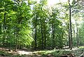
4.) The park area is very densely wooded with over 60% woodland. Near-natural silviculture characterizes these spacious, species-rich forests, which are mainly formed by red beech , sessile oak , red spruce and Douglas fir .
5.) In the park area, around 600 km of hiking trails are maintained by the nature park, for example the Rheingau Gebück hiking trail as well as several information trails, numerous play and sunbathing areas, three youth campsites and several barbecue huts.
6.) Numerous supra-regional hiking trails cross in the park area. For example: Rheinsteig , Rheinhöhenweg , Limeswanderweg , European long-distance hiking trail E1 , European long-distance hiking trail E3
Attractions
Well-known destination is z. B. Above the Rheingau the 580 m high Hallgarter Zange as a vantage point to the south. To the north of it, between the Taunushauptkamm and the Wisper Valley, lies the approx. 220 km² large hinterland forest, which, almost untouched by humans, is unique in the area in its abundance of forests and animals. It is also the largest forest area in Hesse that is not cut up by motorways or federal roads, in which, for example, the wildcat (Felis silvestris) found one of their most important places of refuge in Germany for the second half of the last century.

Erlenbachtal near Wiesbaden-Frauenstein , Sommerberg nature reserve near Frauenstein
Honigberg near Kiedrich

See also
Individual evidence
- ↑ Statutes of the Rhein-Taunus Nature Park in the version dated January 22, 2014, valid from July 15, 2015
Web links
- Participation report 2005. Rheingau-Taunus-Kreis (PDF file 817 KB) Page 140ff: Rhein-Taunus Nature Park
- Website of the Rhein-Taunus Nature Park