Lahn-Dill-Bergland Nature Park
| Lahn-Dill-Bergland Nature Park | ||
|---|---|---|
|
|
||
| Location: | Hessen , Germany | |
| Next city: | Biedenkopf , Dillenburg , Gladenbach , Haiger , Herborn | |
| Surface: | 830.9 km² | |
| Founding: | September 24, 2007 | |
| Address: | Association "Region Lahn-Dill-Bergland eV" Herborner Strasse 1 |
|
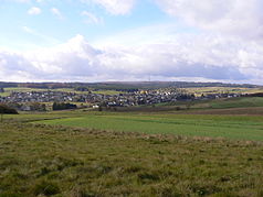
| View of the Damshausen peaks with the 498 m high Rimberg (in the middle, partly covered) in the extreme northeast of the Gladenbacher Bergland. The wide, 474 m high Wollenberg (left) already belongs to the Rothaar Mountains | ||
| The extreme east of the Gladenbacher Bergland: View from Rimberg to the likewise 498 m high Dünsberg (eastern singularity of the Krofdorf-Königsberger Forst es, northwest of Gießen ). On the right the " triumvirate " of Dreisberg (448 m), Koppe (454 m) and Hemmerich (475.5 m, only partially in the picture), east of which the natural area Zollbuche merges into flatter hill country. | ||
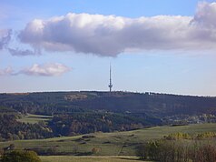
| The Bottenhorn plateau (at 500 m above sea level) with Bottenhorn and the Angelburg transmission tower in the west, on the right in front of the forest the runway of the airfield (special landing site) ICAO code EDGT | ||
| The Angel castle with the Tower of hr as seen from North West of | ||
The Lahn-Dill-Bergland Nature Park has existed since September 24, 2007 . This makes it the eleventh nature park in Hesse and currently has a size of around 83,090 hectares. The nature park is a region characterized by the low mountain range in western Central Hesse ( Germany ). Its composition essentially comprises the former (until 1974) districts of Biedenkopf (today western part of the district of Marburg-Biedenkopf ) and Dillkreis (today north-west of the Lahn-Dill district ), supplemented by the communities of Bischoffen (until 1972 in the district of Biedenkopf). , Hohenahr and Ehringshausen ( old district of Wetzlar ). The municipality of Lohra ( Altkreis Marburg ) was also part of the region and the nature park until 2014, but then withdrew to join the Marburger Land region . The nature park extends over all municipalities in the region since Breidenbach and Dietzhölztal in the north-west, which applied for membership in the nature park in 2008, were accepted after a change in the law in 2017.
geography
Roughly bounded by the Lahn - Dill loop - in the eastern north, however, the Lahn slightly and in the west clearly overflowing the Dill - the region is located in parts of the Marburg-Biedenkopf district and the Lahn-Dill district . Its heartland lies in the Gladenbacher Bergland , in the south-west it meets the Westerwald and in the north-west the Rothaargebirge .
It is bounded by the city of Biedenkopf in the north, the urban area of Gladenbach in the east, the municipality of Ehringshausen in the south and the city of Haiger in the west.
Natural spaces
The Lahn-Dill-Bergland naturally consists to a large extent of the main unit Gladenbacher Bergland in the main unit group Westerwald .
Further main units from the main unit groups Westerwald and Süderbergland are added in parts: The following sub-units are distinguished in the Lahn-Dill-Bergland:
- 32 Westerwald
- 320 Gladenbacher Bergland
- 320.0 Lahn-Dill-Bergland
- 320.00 Breidenbacher Grund
- 320.01 Bottenhorn plateaus
- 320.02 Scheldt Forest
- 320.03 inches Beech
- 320.04 Hörre
- 320.05 Krofdorf-Koenigsberger Forest
- 320.1 Gladenbach hill country
- 320.10 Damshausen hilltops
- 320.11 Elnhausen-Michelbacher depression
- 320.12 Salzbödetal
- 320.13 Niederweidbach basin
- 320.2 Upper Lahn valley
- 320.0 Lahn-Dill-Bergland
- 321 Dilltal (with Struth)
- 321.0 Lower Dill Valley
- 321.1 Upper Dill Valley
- 321.2 Struth
- 322 - High Westerwald
- 323 - Oberwesterwald
- 323.0 Westerwald-Osthang ( Dillwesterwald )
- 320 Gladenbacher Bergland
- 33 Southern Mountains
- 333 Hochsauerland ( Rothaar Mountains )
- 333.0 Dill-Lahn-Eder headwaters
- 333.00 cold oak (with Haincher Höhe)
- 333.01 Ederkopf-Lahnkopf back
- 333.3 Bagpipe
- 333.0 Dill-Lahn-Eder headwaters
- 332 East Sauerland mountain range
- 332.0 Bagpipe foreheads (with Wollenberg)
- 333 Hochsauerland ( Rothaar Mountains )
mountains
If one delimits the Lahn-Dill-Bergland according to the district boundaries of the participating municipalities, the 675.9 m above sea level are. NN high Jagdberg and the also 674 m above sea level. NN high bagpipe - both foothills of the Rothaargebirge - the highest mountains in the region. In the actual Gladenbacher Bergland, however, the 609 m above sea level. NN high Angelburg represents the highest elevation.
The following surveys dominate a. the individual mountain ranges and natural spaces:
-
Rothaar Mountains , Struth and East Sauerland Mountains
-
Kalteiche (with Haincher Höhe) - mountain ridge in a south-west-north-east direction between the valleys of Dill and Dietzhölze in the west of the Lahn-Dill region
- Nordhöll ** (641 m)
- Dillkopf *** (605.9 m, Dillquelle)
-
Cold oak ***** (579.3 m)
- Sinnerhöfchen (572.7 m)
-
Struth (naturally part of the Westerwald , but south-east roofing of the Haincher Höhe)
- Hemmrain (561 m)
- Eibershain (560 m)
-
Ederkopf-Lahnkopf-ridge (headwaters of the Lahn , Eder and Sieg , which connects to the north-west of the Kalteiche and is mostly in North Rhine-Westphalia)
-
Compass ***** (694.1 m)
- Jagdberg (675.9 m) - Compass foothills near the state border
- Eichholzkopf ** (610 m)
-
Compass ***** (694.1 m)
-
Bagpipe (north of the Lahn-Dill region, east of the Rothaargebirge)
-
Sackpfeife *** (673.5 m) - on the border district Hatzfeld
- Hainpracht (631 m) Biedenkopfer Stadtberg
-
Sackpfeife *** (673.5 m) - on the border district Hatzfeld
-
Bagpipe Vorhöhen (eastern roofing of the bagpipe in the Eastern Sauerland mountain range )
- Arennest (592 m)
-
Kalteiche (with Haincher Höhe) - mountain ridge in a south-west-north-east direction between the valleys of Dill and Dietzhölze in the west of the Lahn-Dill region
-
Gladenbacher Bergland
-
Breidenbacher Grund (in the north of the Gladenbacher Bergland, immediately south of Lahn and the city of Biedenkopf )
-
Schwarzenberg * (568 m) - large contiguous forest area south of Biedenkopf
- Hachenberg (552 m) - northern pre-summit
- Nimerich (533 m) - southeastern pre-summit; highest point in the community of Dautphetal
- Schadenberg * (545 m) - in the south
-
Schwarzenberg * (568 m) - large contiguous forest area south of Biedenkopf
-
Bottenhorn plateau - central high plateau around the Bad Endbacher district
-
Angelburg (609 m) - is also counted
as part of the Scheldt Forest
- Schmittgrund (590 m) - southern Angelburg foothills, is also counted as part of the Scheldt Forest
- Hornberg (577 m) - in the west
- Würgeloh (563.9 m) north of Hartenrod / Bad Endbach
- Daubhaus (551.8 m) north of Rachelshausen / Gladenbach , in the east of the plateaus
- Scheid (538.7 m) in the center of the plateaus
- Hünstein (504 m) - not really an independent summit, but with a lookout tower; Holzhausen am Hünstein is named after the company
-
Angelburg (609 m) - is also counted
as part of the Scheldt Forest
-
Schelder Forest (without fishing castle, see above)
- Eschenburg ( 590 m above sea level ) - Western Schelder Forest, at the Dietzhölzetal
- Hohe Koppe (540.2 m) - northeast
- Floor side (516 m) - east
-
Zollbuche (ridge in west-east direction between Schelder Forest and Lohra )
- Schönscheid (498 m) - northwest of Günterod
- Bad Endbacher Platte (487.7 m) - western summit, in the center of the Zollbuche natural area
-
Hemmerich (475.7 m) - in the far east, forms with Koppe and Dreisberg the eastern triumvirate of the Gladenbacher Bergland
- Koppe (454 m) - with a lookout tower; near Gladenbach-Erdhausen
- Dreisberg (448 m)
- Hörre (southwest of the Gladenbacher Bergland, starting east of the Dill between Herborn / Katzenfurt to Bischoffen )
-
Krofdorf-Königsberger Forst (southern and southeastern part of the Gladenbacher Bergland)
- Alteburg *** (442 m) - in the center
- Ramsberg *** (approx. 435 m) - Hohensolms Castle
-
Damshauser Kuppen (extreme northeast of the region east of the Dautphe , which merges into the Marburg Ridge to the east )
- Rimberg *** (498 m) - northeast, with a lookout tower
- Cap (494 m) - north
- Schweinskopf (472 m) - near Dautphetal-Herzhausen in the west of the peaks
- Dusenberg (457 m) - near Dautphetal-Herzhausen in the southwest of the hilltops
- Donnerberg *** (370 m) - in the (no longer very hilly) south of the knolls, northeast of Gladenbach
-
Breidenbacher Grund (in the north of the Gladenbacher Bergland, immediately south of Lahn and the city of Biedenkopf )
-
Westerwald
-
High Westerwald
-
Untitled hill southwest of Langenaubach *** (558 m)
- Bernbergskopf (541 m)
- Hirschbergkoppe (538 m)
-
Untitled hill southwest of Langenaubach *** (558 m)
-
Dillwesterwald
-
Hoheroth (491 m)
- Wacholderberg (473 m)
- Roter Berg (438 m)
- Frauenberg (413 m)
- Kornberg (454 m)
- Gaulskopf (424 m)
- Rodelstein (414 m)
-
Hoheroth (491 m)
-
High Westerwald
(*: on the nature park border, but entirely in the region; **: in the region, but not in the nature park; ***: on the outer nature park border; ****: outside the nature park, on the outer border of the region; *****: outside the region)
history
Contributions to the history of the region can be found in the article Mittelhessen . The mining history is described in the Lahn-Dill area .
Origin of name
The Lahn-Dill-Bergland got its name from the already mentioned rivers Lahn and Dill. The name was derived from the natural area Lahn-Dill-Bergland ( Gladenbacher Bergland ), which, however, has a slightly different surface composition than the region. Since the boundaries of the region correspond to the administrative boundaries of the municipalities involved, some parts of the aforementioned natural area are omitted, while on the other hand parts of the natural areas Dilltal and Hochsauerland (Rothaargebirge) are added. In October 2000, the region was designated as a "Lahn-Dill-Bergland landscape conservation area" by the State of Hesse.
Region Lahn-Dill-Bergland e. V.
The Association Region Lahn-Dill-Bergland e. V. was founded in 1996 by 14 cities and municipalities, as well as a large number of private individuals, companies and associations. As of 2004, 19 cities and municipalities belonged to the association; since 2014, when Lohras left, there are only 18. The association's aim is to promote rural regional development. In 2002 the region was included in a European funding program for rural development (" LEADER + ") and since March 2003 the association has had a full-time regional management team in order to fulfill its role as a funding region. The former member of the state parliament Ernst-Ludwig Wagner acted as regional manager until the beginning of 2013 , who then retired. Marion Klein was his successor. In the meantime, a large number of projects have been launched that serve the development of the region.
In order to strengthen the idea of regional development, the association organizes the Day of the Regions annually in cooperation with the offices for rural areas. This nationwide day of action, which usually takes place on Thanksgiving Sunday, is intended to raise the awareness of the people in the region that they can influence regional development through their own behavior. In 2003, for example, the Day of the Regions was held under the theme “Apple” with the slogan “What does the bee have to do with schnapps?” With a very positive response from the population. In 2005 the day with the topic “Bread” took place under the slogan “From grain to bread” on October 2nd at the Eselsmühle in Lohra. The host is alternately a municipality from the Lahn-Dill district and a municipality from the Marburg-Biedenkopf district.
The following municipalities currently belong to the Lahn-Dill-Bergland e. V. to:
See also
Individual evidence
- ↑ Nature Park - Lahn-Dill-Bergland Nature Park. Retrieved November 9, 2018 (German).
- ↑ Source: Otto Klausing: The natural spaces of Hesse. Hessian State Institute for the Environment, Wiesbaden 1988, ISBN 3-89026-066-7
- ↑ https://www.lahn-dill-bergland.de/region/lösungenskommunen/
Web links
- Internet presence of the nature park
- Map / aerial photo of the Gladenbacher Bergland with rivers, borders and all important elevations


