Eschenburg (mountain)
| Eschenburg | ||
|---|---|---|
|
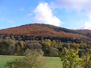
Eschenburg seen from the north-west |
||
| height | 589 m above sea level NN | |
| location | near Nanzenbach ; Lahn-Dill-Kreis , Hessen ( Germany ) | |
| Mountains | Schelder Forest , Gladenbacher Bergland | |
| Dominance | 5.8 km → Angelburg , Bottenhorn plateau | |
| Notch height | 90 m ↓ Wasserscheide , Hirzenhain train station ( location ) | |
| Coordinates | 50 ° 47 '13 " N , 8 ° 20' 42" E | |
|
|
||
| particularities | Model of the Eschenburg Tower | |
The Eschenburg , also called Eschenberg , near Nanzenbach in the Hessian Lahn-Dill district is 589 m above sea level. NN high mountain of the Gladenbacher Bergland . The mountain is considered to be the namesake for the municipality of Eschenburg .
Geographical location
The Eschenburg is located in the northeast of the Lahn-Dill district in the area of the city of Dillenburg . Its summit rises about 6.5 km northeast of the city center, 1.5 km north-northeast of the district of Nanzenbach and 1.4 km (each as the crow flies ) east-southeast of Wissenbach , a district of the municipality of Eschenburg. The dill tributaries Dietzhölze in the north-west and Nanzenbach ( Meerbach ) in the south-east flow past the mountain, each in a north-east-south-west direction . The Hörlestein natural monument is located on the southeast flank .
Natural allocation
The Eschenburg belongs to the natural spatial main unit group Westerwald (No. 32), in the main unit Gladenbacher Bergland (320) and in the subunit Lahn-Dill-Bergland (320.0) to the natural area Bottenhorn plateau (320.01), with the northwest flank in the main unit Dilltal ( 321 ) falls into the subunit Upper Dilltal (with Dietzhölzetal) (321.1).
Eschenburg Tower
In 1934 it was decided to build a lookout tower on the mountain . On June 20, 1936, the wooden Eschenburg tower was inaugurated. Its height was 43 m and a mining museum was housed in the stone base . From the observation deck of the tower one could not only look into the Gladenbacher Bergland, but also to the Westerwald and Rothaargebirge . The tower was set on fire by American fighter bombers on March 23, 1945 and completely destroyed. The stones of the base were used for the reconstruction after the war . Today only a several meter high model of the tower on the mountain reminds of the original.
Traffic and walking
To the southeast, past the Eschenburg, the state road 3362 runs through Nanzenbach along the Nanzenbach ( Meerbach ) and to the northwest runs the federal road 253 , which runs through Wissenbach along the Dietzhölze . For example, starting at these roads you can hike up the mountain on forest paths and paths.


