
Urban history
The history of urban development is a historical science and an individual urbanistic science that researches the history of urban development and urban planning . Urban planning deals with the planned layout of cities , today with the development of municipalities in general, with their spatial , structural , social , economic , ecological and legal structures as well as with the planning of public infrastructure .
The urban morphology enables a special approach to the history of urban construction . It treats the development of cities not so much chronologically , but typologically . The focus is on the urban layout, the building types and the change in the plot structures. A more recent research field based on urban morphology is urban space history , which examines the development of urban space in the respective socio-economic and cultural context.
Epochs of the founding of cities in Europe and the Near East
The epochs of the city expansion can be broken down as follows:
- As early as the 3rd and 2nd millennium BC, the founding city was a common form of town
- The Greek colonial cities
- Founding cities of the Etruscans and Romans
- City foundations in the Middle Ages
Town planning in ancient times
High cultures
- Mesopotamia

The cities of Mesopotamia were mostly laid out around a temple area. A step pyramid ( ziggurat ) marked the city center and was the residence of the city god. As the oldest city in the world and the Sumerians is Eridu suspected.
Babylon (Bab-ili: Gate of God, Hebrew: Babel), was the historic metropolis in Mesopotamia. The city lay on both sides of the Euphrates , over which a bridge led. The north-south axis, the processional street, was the world's first major city boulevard. At its northern end was the Ishtar Gate . Babylon's ziggurat, the Tower of Babel , reached over 90 meters in height under Nebuchadnezzar II . Part of the extensive palace complex were the vaulted hanging gardens , one of the seven wonders of the ancient world.

Reconstruction of the ziggurat of the moon god Nanna in the south of today's Iraq

The reconstructed city walls of Babylon

Model of the Ishtar Gate in Babylon, Pergamon Museum , Berlin


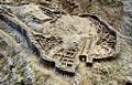
- Indus culture

The cities of the Indus culture were the first in the history of urban planning to have rectangular floor plans, which were evidently viewed as a rational floor plan for thousands of years. The largest known cities of this culture were Mohenjodaro and Harappa in what is now Pakistan.

Extension and most important sites of the Indus culture
Ruins of Mohenjo-Daro


- Egypt
The cities of ancient Egypt were not built to be representative. Much more effort was made with the cities of the dead ( necropolises ). The two capitals of Egypt, Memphis and Thebes , were far surpassed in splendor by their necropolises (e.g. Giza and Sakkara near Memphis and Karnak near Thebes).
- China
In China , cities have been around since the 15th century BC. Proven. In the Shang dynasty , a rich agriculture with isolated market towns and feudal residence towns developed due to the fertile soil of the Chinese lowlands. The first capital of China was Chang'an , today's Xi'an of the Qin Dynasty .
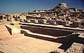
- Mycenae
The most famous city of the Mycenaean culture is Mycenae . It was one of the most important cities in Greece in the pre-classical period.

Location of Mycenaean sites in Greece
Aerial view of the Mycenae excavations

The Lion Gate in Mycenae

The house of the warrior crater in Mycenae


Greek antiquity

From the 7th century BC Greek cities began to emerge both in Greece and outside (→ Greek colonization ). At the time of ancient Greece there were a total of about 1000 Greek cities in the Mediterranean and Black Sea (the Greek city-state was called Polis ). Less than half of these 1000 polis had more than 2000 inhabitants and only 15% more than 5000. The largest polis was Athens . Like all Poleis, it consisted not only of one city, but extended over the whole of Attica (landscape) to 2600 square kilometers and had in the year 435 BC. Approximately 250,000 to 300,000 inhabitants (including 100,000 slaves and 60,000 male, adult citizens), in 325 BC. BC only about 150,000 to 250,000 people (including 50,000 slaves and 20,000 male, adult citizens).
Although the poleis were very different from one another, they all had a few things in common. To almost each of the 1000 polis belonged firstly a city surrounded by a city wall and secondly an agricultural area (the chora ). Within the city wall with its gates and towers there were streets, houses and mostly larger temples. The agora was probably the most important and central place . The agora was a public square where political meetings and votes took place in the democratic poleis. Most of the time, important public buildings such as the town hall ( Buleuterion ) and the seat of government ( Prytaneion ) were located directly at the agora . The acropolis was the mountain of the city, on which in earlier times there was a fortress, later often a place of worship.
Above all, the founding of cities in the Mediterranean region from around 450 BC. Were built according to a grid-shaped plan that goes back to the city planner Hippodamos , who built it in 479 BC. To have developed for the reconstruction of the city of Miletus (→ Hippodamian scheme ). The cities were crossed by main streets ( Plateiai , in Roman times: Decumani ) and connected by cross streets ( Stenopoi , Latin: Cardi ).

The town hall ( Buleuterion ) of Priene
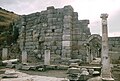
The Prytaneion of Ephesus


Roman antiquity

The Roman cities took over much of the Greek cities, especially the layout according to the Hippodamian scheme. The main streets mostly ran from east to west and were now called decumani , the cross streets to cardi . The rectangles or squares created in this way, on which buildings were built, were called insulae . At the intersection of two streets, mostly in the center of the city, was the rectangular main square of the city, the forum . At the forum , which largely corresponded to the Greek agora , there were important public buildings, such as the court and administration building, sometimes also temples, theaters, amphitheaters or thermal baths, which could, however, also be outside the city. The Roman cities were mostly surrounded by ramparts, ditches and walls with fortified gates.
Famous Roman cities are primarily Rome and Augusta Treverorum (today Trier ), as well as the well-preserved cities of Pompeii and Herculaneum .

Plan of the Pompeii Forum
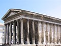
A Roman temple in Nîmes


Roman foundations of cities in Central Europe

- Trier was at times the imperial residence of the Roman Empire and equipped with numerous monumental buildings. In the Middle Ages, when the city was much smaller, the Roman city plan was overlaid by an irregular road network.
- Aachen : Since both the old Roman road network and the Carolingian road network, which is slightly twisted in relation to it, are preserved and overlap in the city center, the city has many triangular squares and lots.
The medieval city
A clear separation into bishopric cities, castle cities and citizen cities is often not possible, as these city types, with their own city rights and privileges, often coexisted. They often stood out from one another by walls and fences within the cityscape, which can still be seen today when looking at the city map.
Examples:
- Münster : Episcopal city on the Domberg, civil city, in a semicircle with the backs of the houses facing the episcopal city around this - Prinzipalmarkt .
- Bamberg : Domberg, Domherrenhöfe, citizen town
- Hildesheim : Domburg 815, old (episcopal) market 1000, old town 1125, new town 1220
- San Gimignano is a small Italian town in Tuscany, in the upper Elsa Valley with a medieval town center.
- regensburg
Episcopal cities
The episcopal see emerged from the Roman municipalities, cities that were able to grant Roman citizenship. In the 7th century the Franks enforced the feudal system and brought power from the cities to the countryside and handed the cities over to the bishops. In the cities of northern Italy, the citizens were able to free themselves and formed the first civil cities in the Protenaissance (Pienza, Florence)
Citizen cities

Although not a citizen town in the strict sense, the Viking town of Haithabu , the most important trading center in the Baltic Sea region from the 9th to the 10th century with only around 1,000 inhabitants, was then destroyed. It was surrounded by a wall that also fortified the harbor.
The cities of the Hanseatic League can be regarded as citizen cities in the true sense of the word . In the (extended) Baltic Sea area they have a typical cityscape, with central squares and churches, town houses with richly decorated façades mostly made of brick and extensive ramparts around the city, such as those in Lübeck , the then Queen of the Hanseatic League and with the almost completely preserved one Old town today world cultural heritage, Hamburg , Wismar or Danzig can be found. Other typical building types in these cities are the extensive warehouses and trading offices as well as the town hall, which played an important role for these cities ruled by the citizens. One of the earliest examples in Germany known in detail was the old town hall in the imperial city of Dortmund on Hellweg .
Cities that were on other important trade routes also achieved considerable importance at that time, e. B. Lüneburg , which was on the Salt Road, or Konstanz , which was on the way from Germany over the Graubünden Alpine passes to Italy.
Other cities, on the other hand, flourished because of their highly specialized industry, such as Monschau in the Eifel, which lived from cloth production. The city's heyday dates from the 16th to the 18th centuries, and since it was never connected to the railroad due to its geographical location in a valley near the Hautes Fagnes, the cityscape from the 18th century with winding streets and many half-timbered town houses with slate roofs have been preserved to this day.
Early modern age
Ideal cities of the Renaissance

- Valletta , founded in 1565 by the Order of St. John, built according to plans by the fortress builder Francesco Laparelli da Cortona
- St. Peter's Basilica with St. Peter's Square
- Weser Renaissance , especially Wolfenbüttel , also Hann. Münden and Bremen Town Hall
- Freudenstadt
- Hartenfels Castle in Torgau (oldest example in Germany)
- Pienza as the seat of the Pope
- Sabbioneta built by Gonzago
- Zamość planned and built by Bernardo Morando (approx. 1540–1600), since 1992 a UNESCO World Heritage Site
Fortified towns


Fortified towns emerged on both sides of the Rhine in the Baroque era. Many of them were designed by the French builder Sébastien Le Prestre de Vauban . He realized his ideal of a fortress town in Neuf-Brisach , which was built between 1698 and 1720. The star-shaped outline with its defenses and the chessboard-like network of streets with its central parade ground have been preserved there to this day, which can be seen very well on the aerial view of the city.
Also Saarlouis was founded as a fortress city. After Lorraine fell to France, the French King Louis XIV had Saarlouis built in 1680 to protect the new eastern border. The plans come from Thomas de Choisy and Vauban himself. The layout was symmetrical in the shape of a star, but unlike in Neuf-Brisach, only basic features have been preserved in the course of further urban development.
The Ehrenbreitstein Fortress in Koblenz, on the other hand, was built relatively late, although it replaces a fortress from the 16th century. This was blown up in 1801 by the French, who had conquered it after the French Revolution, when they had to give up the right bank of the Rhine. In 1815 the Rhineland fell to the Kingdom of Prussia following a resolution by the Congress of Vienna and the re-fortification of the Ehrenbreitstein, which was completed in 1828, began immediately. The Ehrenbreitstein itself was only part of the large-scale Prussian fortress of Koblenz and Ehrenbreitstein, which was completed in 1834. After Gibraltar, the Koblenz fortress with a circumference of 14 km was the largest fortification in Europe at that time.
While a fortress encompasses an entire city, the citadel is only a small part of the city. It is particularly heavily fortified and is usually on the outskirts. Well known is the Spandau Citadel , which was built from 1559 to 1594 on the site of a medieval castle by Francesco Chiaramella de Gandino . Structurally, the citadel corresponded to the ideal of the time. The symmetrically constructed fortress has four bastions, which are connected by curtains. The square curtain wall has an edge length of 208 m × 195 m. Due to the arrangement of the bastions, there were no blind spots in which attackers could hide. The Jülich Citadel was so well laid out that even Vauban was impressed.
Residences of absolutism


The ideal of absolutist urban planning is Versailles Palace with its geometrical layout, the heavy structure that emphasizes the horizontal and its representative design. Even the geometrically laid out and decorative park with its plants cut into artistic shapes is an expression of power.
Some of the royal cities are - such as B. Karlsruhe and Mannheim - founding cities , which can still be seen today in their road network. For example, for Karlsruhe, which was founded on June 17, 1715 with the laying of the foundation stone of the Karlsruhe Palace, the “Karlsruhe Fan” is typical: The palace is located in the center of a circle from which fan-shaped streets into the city to the south and avenues through the Hardt Forest run north. The classicist architect Friedrich Weinbrenner shaped the cityscape in the first half of the 19th century.
The horseshoe-shaped city center of Mannheim also has a rectangular street grid. The castle is in the southwest. From here, the "Breite Straße" goes straight through the city and is crossed halfway up by the "Planken" (in the area D1 / E1; O1 (Paradeplatz) / P1). Other streets run parallel to these main streets, dividing the city center into rectangular plots, which are colloquially referred to as "squares". Most of the streets in the city center have no name, but the "squares" are named from a combination of letters and numbers.
Typical examples of residence sites that have been expanded into residential cities in the course of their history are Potsdam and Dresden . Potsdam was a small, insignificant settlement for a long time, but the expansion into the hunting residence of Elector Friedrich Wilhelm von Brandenburg (from 1660) gave the city an impetus for development. It became an important garrison location for the Prussian army and the city palace was later used as the summer residence of the Prussian royal family. Other palaces were built later, such as the New Palais and Sanssouci Palace with a large palace park and artificial vineyard, so that today the city's parks and residences are particularly impressive. For the Dutch, whom Friedrich Wilhelm I brought to Potsdam, a separate quarter (the Dutch Quarter) was created in 1733–1742, which is based on Dutch cities with its brick houses and facade designs. Another special urban development feature in Potsdam is the Russian colony Alexandrowka , which was laid out with wooden houses in the Russian style at the time of the Napoleonic wars.
Dresden was a royal seat much earlier than Potsdam, but has only been the residence of the Albertine line since the division of Saxony ( Leipzig division ) in 1485. In 1491, most of the city fell victim to a major fire, after which the fortifications of the city were strengthened and the Georgenschloss was built in 1534–1537 . The really formative expansion, however, took place under the government of Friedrich August I (called the "Strong"), who rebuilt Altendresden , which burned down in 1685, as a new town . During this time, many important structures such as the log house , the knight academy, the barracks, the Japanese palace , the Zwinger building , the Dreikönigskirche and the Frauenkirche were built .
The extensive complex in Wörlitz , which was built at the end of the 18th century, is already an alternative to the representation of power in the royal cities. In place of the geometrical forms, the landscape garden , which was criss-crossed by visual axes and monuments, was laid out quite systematically, but was always supposed to appear random and natural. From the Enlightenment , the idea arose for the first time that the complex should not only serve the representation of power and the personal edification of the ruler, but should also serve to educate the common people. For this reason it was largely accessible to the public and also contained model agricultural facilities.
classicism
Buildings and architecture of classicism were based on the architectural style of ancient buildings in the years 1770 to 1840. For example, large porticos were built based on the Greek model and the arrangement of columns was often found. This architectural style can be found particularly in representative buildings such as triumphal arches, city gates and museums or for nobles and wealthy citizens, which with its clear lines based on the Greco-Roman model appears rather simple and functional. It spread throughout Europe in the course of the conquests of Napoleon Bonaparte. A classicist building is, for example, the Munich Glyptothek (built 1816–1830) by the architect Leo von Klenze , which with its vestibule resting on Ionic columns is reminiscent of Greek or Roman temples. Stylistically, classicism is a reaction to the ornate, ornamental art of the Rococo. Scientific studies of ancient works of art formed the basis for the construction in simple forms with a clear structure. Geometric shapes such as triangles, squares, circles, spheres or pyramids predominate in classical buildings.
Examples:
- Buildings by Karl Friedrich Schinkel in Prussia, especially in Berlin.
- Brandenburg Gate in Berlin
- Parts of the former Brunswick residential palace or the Salve Hospes merchant's villa designed by Peter Joseph Krahe for the merchant Dietrich Krause
- Arc de Triomphe de l'Étoile and Arc de Triomphe du Carrousel in Paris

Brandenburg Gate

Brunswick Castle
Villa Salve Hospes

.jpg)
.JPG)
19th century urban planning
The industrial city
In the course of industrialization and population growth, the cities in Germany expanded rapidly from the middle of the 19th century. Their growth was coped with differently. On the one hand, the cities were allowed to grow along existing connecting roads and around industrial plants; on the other hand, the construction of streets, squares and entire districts was planned from scratch. The spatial structure of the city extensions was mostly based on regular geometric concepts: straight streets were predominantly used, the building block was the basic urban planning element.
Even within the historic city center, economic development and population growth were reflected in an unprecedented reconstruction. The beginning of urban development led to greater densification and deteriorated housing conditions with a higher zoning of the buildings, historic buildings fell victim to traffic-related straightening or major road openings and widening, with the relocation of the business centers in the direction of the Wilhelminian new- build districts and train stations, the old towns lost their function as focal points of economic life. In view of these massive upheavals, urban development relationships and the maintenance of the cityscape received more attention.
Speculation and Housing


While the wealthy bourgeoisie lived in relatively spacious and green villa districts at the time of industrialization (e.g. the villa colony of Lichterfelde near Berlin and in Vienna - Döbling on the edge of the Vienna Woods ), the lower class of the population could only afford an apartment in a multi-storey tenement . In the big cities (especially Hamburg , Berlin and Vienna) these were built only with the aspect of profit maximization in mind and therefore only had inadequate sanitary facilities. Washbasins, also known as bassena , and toilets were often only in the corridor. As a rule, there were several rear buildings and a number of inner courtyards, in which there were often commercial establishments and in which there was little light even during the day. Nevertheless, the residents had to spend 25 to 30% of their income on the two- to three-room apartments, which consisted of an eat-in kitchen and one or two rooms. Often the additional rooms in the cramped apartments were sublet or a bed was rented to a so-called sleeper or bed-walker .
The living conditions in the tenements not only gave Heinrich Zille endless material for his drawings, which depict life in Berlin very vividly, but also inspired Adolf Damaschke to write a book about land reform.
In Vienna, which at that time experienced unprecedented population growth - the population grew from one to two million between 1870 and 1910 - the suburbs, which were still characterized by village architecture until the middle of the 19th century, were incorporated. The inner districts, and some of the outer ones, were planned in a grid in view of the strong population growth and dedicated to residential buildings. Often the old building structure consisting of village squares, winding alleys and backyards was deliberately overdrawn and abandoned for demolition, so that today only street and stop names are reminiscent of the former villages in the former suburbs of Vienna. Most of the buildings built during the founding period are still preserved today and shape the cityscape of Vienna with their neoclassical facades.
Haussmann in Paris
Baron Haussmann was the executor of the "Points de vue", a boulevard that cut through the city and made it the capital of the 19th century. From 1853 to 1869, around 27,000 buildings were demolished and 100,000 rebuilt, the road system was expanded by 200 km from the former 384 km network.
This was not the only measure to straighten the cityscape, Napoléon already tried to rationalize the overpopulated, poorly ventilated, medieval city with new straight streets. He had a few new streets built. In 1848 Napoléon III came through the revolution . to power, he consistently continued the fragmentary ambitions of his uncle. It wasn't just aesthetic (e.g. great views of monumental buildings) and traffic-related reasons (e.g. boulevards as connections between different train stations), military considerations also played an important role. Broad streets could no longer be blocked by the people's barricades as easily as before, and the artillery was more effective in straight streets. By giving preference to poorer neighborhoods, cheap labor could also be recruited and used. The medieval city was covered by a new system of streets, which was immediately taken over by the new bourgeois class.
Benevolo describes Haussmann's planning and construction measures as a prototype of neo-conservative urban planning that will be decisive for the second half of the 19th and early 20th centuries. In this sense, Haussmann followed the “conventional principles of French town planning, as laid down by Henry IV and further developed by Louis XIV, and which culminated in Hausmann's direct model, the 'Plan der Künstler' ( Plan des Artistes ) of 1797: Lange , straight boulevards that meet like a star in round squares are the leitmotif. " Plan des Artistes (Paris 1793), Barauderies Petit Parc in Versailles and André Le Nôtres Versailles garden extensions (1662–1689), but also the urban planning ideas of Christopher Wren ( London 1666) and Sixtus V (Rome 1588) are processed.
Ring streets and boulevards on free bastion areas
The 19th century was the century in which the cities were “de-fortified”. The freed-up areas of the ramparts , over which the city had often already outgrown, were a great opportunity for fundamental corrections to the city's layout. Depending on the shape of the bastions, for example, ring roads (Cologne, Vienna, Olomouc, Brno, Budapest) were created. Bremen owes its ramparts converted into a park to the bastions, Düsseldorf the Königsallee and Aachen the Monheimsallee. Some of the military installations fell at the request of the victorious French (at the beginning of the 19th century, e.g. in Düsseldorf), some of their own free will because of their futility. This gave urban development new opportunities and tasks that were used for systematic urban expansion planning. The development of the vacated bastion areas made high functional and design requirements. These were neither possible with simple grids nor without a detailed examination of the internal and external connections to existing roads and the settlement that developed in front of the walls. Most cities recognized the opportunity to use the area of the ramparts for a generous addition to the road network with a ring road. Such decisions require an in-depth analysis of future urban development. Several large competitions were therefore used to search for the best concepts. The competitions for the Vienna Ringstrasse (1857) and the Cologne Ringstrasse (1870, later Cologne Neustadt) were outstanding. Other competitions aimed to gain clarity about the shape and organization of the developing city.
The Vienna Ringstrasse

In 1857, after a competition, construction of the Vienna Ringstrasse began. There were very extensive requirements for the use of the individual buildings on the ring (barracks, opera house, imperial archive, town hall, market halls, etc.). In the tender it was required that the new buildings “connect organically to both the inner city (...) and the suburbs. The proposals should take into account the practical needs of the population in technical and artistic terms ”. 85 participants submitted proposals. Three first prizes of equal rank were awarded to Friedrich Stache , Ludwig Förster and Eduard van der Nüll / August Sicard von Sicardsburg . On the basis of the first prices, a “basic plan” was drawn up by a commission, which Emperor Franz Josef I personally approved on September 1, 1859. The Ringstrasse was officially inaugurated in 1865, around 40 percent of all land by 1873 and almost everything by 1890.
The ring development had to take into account both the connections to the existing old town and the suburbs that had already arisen before the bastions. A continuous boulevard leading to the Danube served as a spatial means of organization. In order to change the angle, the ring road was designed not round, but in straight sections, from which the building areas were added to the existing buildings using a simple grid system. This enabled oblique blocks and sharp block corners to be concentrated in a few places. At these diagonal points, radial roads were partially linked, while the angular problems were partially solved by triangular parks. A special feature were the numerous large public buildings that gave the individual districts central points. Combined with the many spacious parks, the Wiener Ring became a central cultural and administrative zone supplying both the old town and the new suburbs. Today, after the renovation of numerous buildings, the Ringstrasse has largely been preserved and still fulfills its role as a mediator between the old town and the outer districts in an exemplary manner. There is no better example in Europe.
The Hobrecht Plan for Berlin
The Hobrecht Plan is the usual name for the development plan for the surroundings of Berlin, named after its main author, the sewage engineer James Friedrich Ludolf Hobrecht and which came into force in 1862. As an alignment plan, this should regulate the routing of ring roads and arterial roads and the development of the cities of Berlin, Charlottenburg and five surrounding communities for the next 50 years. His plans laid the foundations that Berlin could enlarge five times. He was not concerned with changes for the city, but only focused on the expansion by laying a rough grid over the surroundings of Berlin. This grid was mostly based on the property boundaries of the farmers, since at that time the state had hardly any rights to intervene in the property.
Artistic urban planning
The geometric urban planning of the 19th century, with all the strengths in the large-scale organization of the city, had a clear weakness in design thinking: One could not decide on curved streets, not on arrangements derived from given conditions. An otherwise successful system would inevitably face insoluble problems with special local conditions that stood in the way of geometrical divisions. Camillo Sitte brought movement into this situation in 1889 with his book “Urban planning according to its artistic principles”. With his investigations into older places, Sitte makes people aware of forgotten compositional principles. He starts from the aesthetic diversity but also from the use and shows that it is more beneficial to preserve public life in the city to concentrate important buildings around a few places, instead of distributing them to many places, buildings from the structural context than To detach solitaires and to design them as axis points of view. He calls for a return to the design features of usable spaces. By this he understands places with closed structural walls and an available free space. Therefore, the center of the square should be kept free of monuments, and should rather be placed on the walls of the square. Places should be designed in such a way that they appear closed.
With Sitte's position, the aesthetics of the irregular urban space and criteria of perception and use are introduced into the discussion. One can hardly overestimate the effect of this contribution. Its still great importance today stems from the fact that Sitte was the first to propose a theory of a non-geometrically oriented design theory with his examples.
Sitte's ideas were mainly taken up in Germany by Karl Henrici , professor of architecture in Aachen and in England by Raymond Unwin (Gartenstadt Letchworth 1904, Gartenvorstadt Hampstead 1906). A large part of the garden suburbs that emerged in Germany in the first third of the 20th century followed these suggestions with curved streets and closed squares. Examples: Dresden-Hellerau 1908, Krupp-Siedlung Margarethenhöhe 1907, Berlin Tempelhofer Feld 1911, Gartenstadt Falkenberg Berlin-Grünau 1912.
The bourgeois villa colony

The bourgeois villa colony developed from the middle of the 19th century, especially in German-speaking countries . Often generously laid out, with a multitude of squares and avenues, entire residential areas were created, which were built exclusively with villas. In the early systems, the public space was largely designed following a uniform artistic taste. The villas themselves showed the ingenuity of Wilhelmine bourgeois building in eclectic combinations of the most varied architectural styles. The villa colonies emerged, following the desire for space, nature and healthy air, predominantly in the up to then rural suburbs of the big cities and quickly developed into the “top addresses” of the cities. To this day, cities in German-speaking countries are characterized by the fact that the most expensive residential areas are not to be found in the center, but in residential areas. Early examples of closed villa colonies are Marienthal in Hamburg or the two Lichterfeldes in Berlin , later the Hohe Warte or the Cottage Quarter in Vienna .
The bourgeois villa colony was an important source of ideas for the concept developed in England of a garden city specially built for the workers and the broader masses.
The garden city movement

The pioneer of the garden city movement was Ebenezer Howard , parliamentary stenographer from London with his book “Tomorrow. A Peaceful Path to Land Reform. London 1898 ”.
Planned and implemented forerunners of the garden city:
- 1773: Chaux salt works (France) by Claude-Nicolas Ledoux
- 1817: New Harmony by R. Owen, an 1824 town plan by St. Whitwell
- 1808: Phalanstère , Charles Fourier's residential cooperative
- 1851: Saltaire near Bradford . Founder: Titus Salt
- 1859–1863: Akroydon in Boothtown, suburb of Halifax, West Yorkshire . Founder was Lieutenant Colonel Edward Akroyd, architect George Gilbert Scott Jr. and William Henry Crossland
- 1875: Bedford Park in Chiswick / London; Architects Richard Norman Shaw , MB Adams et al.)
- 1879: Bournville / Birmingham ; Founder G. Cadbury, Architect A. Harvey
- 1888: Port Sunlight in Birkenhead , near Liverpool ; Founder: Lever.
Important examples in England:
- 1903: Letchworth Garden City (Unwin & Parker)
- 1906: Hampstead garden suburb, London (Unwin & Parker)
- 1919: Welwyn Garden City (Louis de Soissons)
The transformation of the garden city into a car-friendly suburb in the USA:
- 1928: Radburn (C. Stein), the first settlement designed with a consequent separation of driving and pedestrian traffic. According to Mumford, the biggest innovation in urban development after the construction of Venice with the development of canals.
Howard's contribution to urban development (which picks up on earlier approaches and bundles them more coherently), to steer the ring-shaped growth of London through the establishment of new independent cities in the countryside, which are essentially satellite cities and which offer affordable housing for the workers, was probably the most momentous concept for that 20th century. Like Berlin and other rapidly expanding mega-cities for the time, London was faced with the task of relocating large masses of poor populations from the big city slums to healthier surroundings. Just as in architecture style borrowings from the past promised a psychologically calming effect against the uncertainty of the new era, the vision of dissolving big city growth into a pearl necklace of small towns with 30-50,000 inhabitants was able to stimulate the imagination of those living in the big city of dreamed of a more contemplative country life. In the tradition and with the optimism of the English paternalists, Howard succeeded within a very short time in founding a garden city society, which set itself the goal of building garden cities. Six years after the book was published, the first garden city, Letchworth, about 50 km north of London, was under construction. The second garden city, Welwyn Garden City, followed, delayed by the World War in 1919. The concept aims to solve several basic problems: In regional planning, the ring-shaped urban growth should be diverted into these by a ring of garden cities; socio-politically, the contrast between country and city should be abolished in the “country-city”; In terms of social and land reform, speculation and social inequality were to be prevented through the formation of communities (spatial cluster formation) and the fact that the land could not be traded as common property. The garden cities were designed exclusively for the "working class" from the start, the British upper class usually had houses in the expensive districts of London and an extensive country estate, the middle class, which was only gradually developing, initially orientated itself largely to the housing ideas of the Upper class.
The urban planning concept of the garden city is a reflection of these goals. Howard's concept, which he illustrated in a scheme, is fascinating due to the reversal of the classic distribution of use: The core of the garden city is not a business center, but a central park, around which a “crystal palace” was arranged in a circle as a promenade. Public facilities, offices and apartments followed in rings. Less disruptive trade and industry were arranged outside. If you see this scheme together with the situation, the early concept of a service and leisure city was drawn up here. This becomes particularly clear with the idea of the city center: Instead of the medieval city crown or the concentration as a business center, Howard imagines a park as the center of the new city. A reversal of the classic usage morphology. Although Howard understood his concept only as a scheme and not as a draft, it still provides sufficient clues as to which direction it was thinking.
The impetus in England gave rise to a worldwide movement to build green garden cities and garden suburbs, which continues to this day. The conception of the "New Towns" as relief cities of large conurbations in England after the Second World War and the concept of dependent satellite cities, as proposed in May 1924 in a competition for Breslau , also emerged from this root . May, who previously worked in the Unwin office, also brought Unwin's urban space approaches to Germany. The idea of the garden city spread across developed countries in just a few years. It came at a time when large-scale urban expansion and the incipient suburbanization required concepts. But instead of leading to a new type of city, formal borrowings were used for suburbs and suburbs. The German scene reacted particularly quickly: the German Garden City Society (DGG) was founded as early as 1902, just three years after the English one.
Examples in German-speaking countries
The garden cities became the training ground for the new theory of artistic urban planning. Since garden cities are smaller units without strong connections to the surrounding area and planning implemented relatively quickly, theories of urban development could be tested and implemented relatively easily. Indeed, the garden cities were given an important place in this regard. While there was an irreconcilable debate about straight and crooked streets in Germany (which of course also included a debate about the opinion leadership of urban planning theories), Raymond Unwin made undogmatic use of both principles in his design for the garden city of Letchworth and a little later for the garden suburb of Hampstead.
In Germany, many garden cities emerged at the beginning of the 20th century , including the garden city Margarethenhöhe in Essen, Karlsruhe-Rüppurr (1907), Dresden- Hellerau (1908), Dresden- Briesnitz (1911), Stuttgart-Luginsland (1911), the garden city Marga in Brieske near Senftenberg in Brandenburg, the Teutoburgia settlement in Herne-Börnig, the garden city Vahr in Bremen and the districts Welheim in Bottrop, Emst in Hagen (Westphalia), garden city Crengeldanz in Witten and Magdeburg-Reform .
The Gurten Garden City , a noble residential area in the agglomeration of Bern, was built in Switzerland. One response to the car is the concept for development on the Radburn System , which was named after the city of Radburn , New Jersey , where it was first implemented. The development consists mainly of dead ends, so that children could get to kindergarten and school through a green space almost without crossing a street. There was also hardly any through traffic. Since then, this principle has been used in many suburban settlements.
Other examples
- Letchworth Garden City and Milton Keynes in the UK
Capital foundations
In the tradition of the ideal city concept , which can be traced from the Renaissance through absolutism and the 19th century to the modern age, there are the founding of completely new cities as planned capitals of individual nations. In contrast to most other ideal city projects, which mostly remained unrealized or were only implemented on a smaller scale (e.g. garden cities), the exertion of an entire nation made it possible to build quite large cities. The location of the new city was not always chosen according to rational criteria, but often as a compromise between two dominant parts of the country. In very few cases was the new seat of government able to outstrip the metropolises of the previous city system in importance.
Examples:
- Saint Petersburg , Russia (1703). Founded under Tsar Peter I to open Russia to the west. Capital from 1712 (until 1918) instead of Moscow .
- Washington, DC , USA (1790, Pierre L'Enfant ) On the border between the Northern and Southern states.
- Ottawa , Canada (1857) Expansion of an existing small town on the border between Ontario and Québec into the government capital.
- New Delhi , near Delhi , then British India (1911, Edwin Lutyens ; inaugurated in 1931) instead of Calcutta .
- Islamabad , near Rawalpindi , Pakistan (1958, Constantinos Doxiadis ) capital since 1963 instead of Karachi .
- Canberra , Australia (1913, Walter Burley Griffin ) Planned as a large garden city, halfway between Sydney and Melbourne.
- Chandigarh , Punjab, India (1951, Le Corbusier ).
- Brasília , Brazil (1956, Oscar Niemeyer ) Relocation of the seat of government from the coast to the interior. Capital since 1960 instead of Rio de Janeiro .
- Yamoussoukro , Ivory Coast (1964) Relocation of the seat of government from the coast to the home village of President Félix Houphouët-Boigny . Capital since 1983 instead of Abidjan .
- Abuja , Nigeria (1976, Kenzō Tange ) Relocation of the seat of government from the coast to the interior, capital since 1991 instead of Lagos .
- Dodoma , Tanzania , in 1974 it replaced Dar es Salaam as the capital.
Urban planning in the 20th century until 1945
Athens Charter
The Athens Charter (CIAM) , developed under the leadership of Le Corbusier , was adopted in 1933. It strived for a functional city through the unbundling of urban functional areas and the creation of livable living and working environments and influenced - often misinterpreted - urban planning from the post-war period until today.
The Athens Charter was aimed specifically against the urban planning “sins” of the past and against the cramped and unhealthy living conditions that prevailed in the city at the time.
The best-known example of a city that consistently implements the principles of the Charter of Athens and is accordingly car-oriented is Brasília .
The "structured and loosened city"
- Jarrestadt large estate in Hamburg- Winterhude, 1926–1934 by Fritz Schumacher as urban planner and Karl Schneider as architect.
- The Hufeisensiedlung (settlement Britz) was built from 1925 to 1933 in the south of Neukölln (Berlin) according to plans by Bruno Taut and Martin Wagner .
- The Weißenhofsiedlung in Stuttgart was built in 1927 under the direction of Ludwig Mies van der Rohe by leading representatives of the New Building, partly using experimental materials.
Urban development at the time of National Socialism
Even in the Third Reich, there were no uniform ideas about architecture and town planning. The various styles borrowed from architecture during the National Socialist era characterize a policy that, on the one hand, seeks to set itself apart from the international style of the 1920s and therefore takes up historical and regional traditions. On the other hand, a remoteness and sublimity appropriate to the vision of a new, “millennial empire” and at the same time a temporal independence of the architecture are sought. Both directions stand for essential features of the ideology of the Nazi regime. There is a gap between the purism of the “New Building” of the 1920s and the monumental neoclassicism of Hitler and Albert Speer, which was based on Schinkel. However, where the “New Building” has produced solutions of classic simplicity, particularly in the case of functional buildings, there were points of contact. The architecture was under public control, but in urban planning the principles of spatial urban planning, as taught by the garden city movement and by the “Stuttgart School” around Schmitthenner, Wetzel and Tessenow, continued to be used.
Characteristic projects and publications
- Wolfsburg : 1938, “City of the KDF Wagons”, planning by P. Koller
- Salzgitter : 1939, city of the "Hermann-Göring-Werke", design by H. Rimpel
- Berlin : General development plan (GBI)
- Berlin: Central axis formations of Speer
- Berlin - Südstadt from 1938 to 1941.
- Berlin: World capital Germania , Olympiastadion Berlin , ministries (today: Ministry of Finance, Ministry of Foreign Affairs, etc.)
- Munich : plans for the renovation
- Nuremberg : Nazi party rally grounds
- Warsaw : plan for a “German” city, architect Pope, 1940
- Gottfried Feder : The New City . Concept for cities based on the infrastructure hierarchy, 1939.
- Hamburg : General development plan 1944 (reconstruction plan) by Konstanty Gutschow
Reconstruction or rebuilding of destroyed cities after 1945
Phases of urban development after the war
- Reconstruction according to old or new concepts, first reconstructions (from around 1945 to around 1955)
- The structured and loosened city (around 1955 to 1970)
- Re-urbanization through densification, "vertical urban development", new centers, area renovation (from around 1960 to 1980)
- Urban repair , true-to-scale insertions, urban development funding , improvement of the living environment, careful urban renewal , ecologically oriented urban development (from around 1970 to 1990)
- Urban development in international competitions ( International Building Exhibition 1987 in Berlin), correction of structural breaks, further redirection from individual traffic to public transport, innovation-oriented and architectural / ecological upgrading of industrial areas (from around 1985)
Reconstruction from 1945 to around 1955
First the rubble was cleared away. The building activity concentrated on the destroyed city centers and districts. First corrections were made on important roads (widening). Due to a lack of time, resources and mature alternatives, the old parcel structures were often rebuilt. Corrections were made to central business and traffic axes, but they were seldom fundamental. This approach had advantages: The entire development of the property was available with roads and supply lines. The ownership structure was clear, and the rebuilding of the old buildings or new buildings on the same plots was structurally permissible even without new law. Often there were still considerable remains of buildings. In a time of massive housing shortage, it was therefore necessary to quickly convert the legal and financial advance payments that existed in the old structures into new construction volumes. In this way, the building and structural relationship between the existing districts was often retained.
The following models characterize the first building phase (after von Beyme 1987) for the inner areas of the heavily destroyed cities:
- Reconstruction of the existing = reconstructive reconstruction
- Elimination of the existing = new building
- Compromise as a middle way = traditional adaptation
The structured and loosened city from 1950 to 1970
With the gradual solution of the most urgent construction problems, new ideas could take hold in areas in which there were only few ties due to demolitions or their location on the outskirts. The ideas that prevailed in the minds of architects and town planners about the role of residential areas in the modern city can best be seen in the first competitions of that time.
Although the large residential complexes Siemensstadt , Römerstadt and the so-called Hufeisensiedlung from the 1920s were excellent examples of space-defining construction, most architects oriented themselves towards the structural and social concerns of the "modernity" of linear buildings, which had already become questionable towards the end of the 1920s . The line seems to have been a dogma, a symbol of progressiveness. It was able to meet the demand for optimal alignment to the sun, for ventilation and greening of the city and appeared economically as a location-independent, basically worldwide usable basic element of urban development. It offered enormous advantages in accelerating planning by eliminating the need for corner solutions or transitions to be planned individually. Building complexes that could be made into larger, horizontally addable and vertically stackable residential or house units made it possible to multiply proven floor plans and reuse plans and cost structures. So an element came into universal use, which, due to the property of a system-related distance to the next building, also made it possible to fit into completely different surrounding structures. With the mass success, however, doubts also arose. Critics pointed to the loss of spatial cohesion, to monotony. The strangely diffuse intermediate areas turned out to be unsuitable for use because of their susceptibility to failure. They are fully controlled and hardly allow private appropriation. Not only does fresh air penetrate the flowing space, but also wind, dust and noise. “Life in the park”, which was initially perceived as positive, gradually lost its tension. In particular, the lack of a mix of uses, which essentially defines the city, led to the impoverishment of social experiences, which were reflected in the first symptoms of crisis as early as the 1960s.
Three important theoretical contributions influenced spatial thinking in these years: Reichow's books Organic Urban Architecture, 1949, and Die Autogerechte Stadt, 1959, as well as the book by Göderitz , Rainer , Hoffmann : The articulated and loosened city, 1957 Core anti-urban currents that had spread since the garden city and the reform ideas of the housing reformers in the 20s. Thus, the principles of CIAM were shaped into a spatially illustrated urban planning model, which had more distinct small-town features than z. B. the large housing estates of the 1920s in Berlin, Frankfurt and Vienna. The thinking was clearly based on living as the most important function and subordinated all others to it. In those years, urban development on the outskirts was mainly residential. With the concept of the car-friendly city, Reichow picked up on considerations that had already led custom to criticize the intersection and which had since been shaped in artistic urban planning and in many garden city concepts. A striking example is the Sennestadt, which is now part of Bielefeld, and was built based on this model. With the development of separate systems, the concept of separation of functions was also drawn from the concept of development . The settlement planning integrated the car with its own traffic route and thus abandoned the millennia-old concept of mixed and built-on roads.
During this time, there were also increasing numbers of concepts for large housing estates on the outskirts. In these, too, the row structure prevailed, whereby the large dimensions of the settlements were softened by a vertical accentuation (higher center). In the period that followed, efforts were made to differentiate and bend lines, to create sub-areas and to differentiate settlement areas more clearly. The residential high-rise as a solitary building was added as a new element in the differentiation of the rigid line scheme, initiated by Scandinavian examples. Instead of using row and row buildings of roughly the same height, row buildings were now mixed with point houses and low-rise buildings (often garden courtyard houses with flat roofs). Examples: Neue Vahr Bremen (1956–623), Kiel-Mettenhof, Cologne-Bocklemünd and Neuss-Vogelsang. Apparently an attempt was now made to counteract the monotony of similar building types through a greater range of variation in form and height.
The early large housing estates
The new large settlements had 10,000 to 60,000 inhabitants. Fritz Jaspert from the Housing Ministry criticized the choice of 10,000-inhabitant units because they were too small for an independent district but too big for a settlement. The inner-city settlements Grindelberg in Hamburg and the Berlin Hansaviertel, a product of Interbau Berlin from 1957, were built according to the same spatial principles but with a very high number of floors .
Examples of new large estates from this time:
- Augsburg: City expansion, 10,000 inhabitants
- Berlin Charlottenburg-Nord 1955–1960 (Scharoun)
- Berlin-Hansaviertel . Urban planning: Jobst, Willy Kreuer , plan changes based on suggestions from Bakema and Scharoun. Construction: 1956–1958 (conceived as a "free alternative" to East Berlin's Stalinallee. Construction of the building as part of "Interbau" by internationally known architects)
- Berlin-Wedding, 20,000 inhabitants
- Bielefeld : Sennestadt
- Bremen - Neue Vahr , 40,000 inhabitants
- Hamburg: Grindelhochhäuser , 1946–1956, planner: ( Hermkes , Jäger, Lodders, Streb, Trautwein, Sander, Hopp, Jeß)
- Hamburg: Hohnerkamp 1953–1954 (Reichow)
- Munich-Bogenhausen
- Nürnberg- Langwasser (from 1950)
Examples of inner cities
Germany
- The inner city of Eisenhüttenstadt in Brandenburg was the first and only planned city to be completely rebuilt after 1945 without a previous model in the same place. The new socialist residential town was to be built according to the “ 16 principles of urban development ” and in the architectural style of socialist classicism near the historic town of Fürstenberg (Oder) .

- Dresden's inner city is made up of the inner old town , the Seevorstadt , the Wilsdruffer Vorstadt , the Pirnaische Vorstadt and, on the north side of the Elbe, the Inner Neustadt . All of these districts were largely destroyed in the air raids on Dresden . Also Dresdner suburbs as the Johannstadt that Pirnaische suburban or Friedrichstadt were extensively destroyed. The big attack on 13/14 February 1945 spared the villas and loose buildings in the urban districts of Striesen , Blasewitz and Strehlen .
- Shortly after the war, the reconstruction of some historical buildings began in Dresden ( Zwinger 1951; Japanese Palais 1951 to 1963; Kreuzkirche until 1955; Catholic Court Church until 1963; Semperoper 1977 to 1986). After reunification (1990), the Frauenkirche (1994 to 2005) and the Dresden Residenzschloss (since 1985) were also rebuilt. The construction cost a price that could hardly be quantified. Some structures or their ruins were removed in order to use their building materials elsewhere.
- Of the 27 bombed-out churches in Dresden , many were not rebuilt or torn down. For example, the SED regime had the Sophienkirche torn down in 1962.

- The development next to these main structures in the historic old town was hardly carried out according to historical plans. The residential areas in the city center were completely gutted until the 1950s and then rebuilt. The Seevorstadt is characterized by modern buildings from the 1970s along Prager Strasse . The old market was built on by buildings in the style of socialist classicism . In both cases, the historic streets were broken, the alley character destroyed.
- Only the quarter around the Neumarkt will be built up again in such a way that the historical streets and proportions will be restored. Since the Theaterplatz is surrounded by historical buildings, but has no residential development, the creation of living space based on historical models on the scale of the Neumarkt is a novelty in Germany. Nevertheless, there is criticism of this development from many sides , the modern buildings behind hide historicist facades. Although the city center is car-unfriendly in the area due to the narrow streets and pedestrian zones, the Neumarkt is perceived as a historic city center with an underground car park .
-
The densely built-up, essentially medieval Frankfurt old town was almost completely destroyed by the air raids on Frankfurt am Main . During the reconstruction in the 1950s, apart from the endowment churches, only a few striking buildings such as the Römer , Goethe House and Saalhof were rebuilt. In the majority of the old town, new buildings were built, including some such as the Frauenstein and Salzhaus houses, which are part of the town hall complex, based on historical forms. The land and transport network were completely redesigned according to the concept of the car-friendly city , which changed the structural character of the city center significantly. The historical center of the city between the cathedral and the Römer initially remained a fallow landscape, the development of which has long been debated. It was not until the beginning of the 1970s that two large monolithic buildings in the brutalist concrete style were built: the Technical Town Hall (1972–1974) and the Historical Museum (1971/72) .
 Dom-Römer-Areal in summer 2017 during the construction phase
 - 1981 to 1983, after long political disputes, the historic east side of the Römerberg was reconstructed with five half-timbered buildings, above all the community center Großer Engel . Plans for the reconstruction of the Technical City Hall that emerged from 2004 finally led to the Dom-Römer project in 2007 : The Technical City Hall was demolished from 2010 to 2012 and most of the historic properties, streets and squares, including the chicken market and old market , were spread over an area of around 7,000 square meters restored. In 2012, the construction of 35 new buildings began, which should be completed by September 2018. 15 of the new buildings are reconstructions of destroyed old town houses, including the Haus zur Goldenen Waage , the New Red House on the market and the Haus zum Esslinger, some of the most historically significant former buildings in the old town.
.jpg)

- Hamburg was quickly accessible for the units of the RAF Bomber Command from Great Britain . As the location of several large shipyards and refineries, the city was an important target and was often attacked. In the summer of 1943 led Operation Gomorrah the Royal Air Force to a firestorm , the most buildings of downtown Hamburg fell victim. After the end of the war, the historic buildings were largely restored, especially on the banks of the Elbe and around the Alster, but many historical residential buildings, some of them very old, were lost in the air raids - especially in the Gängeviertel . Many buildings there were demolished in the interwar period in order to improve the hygienic situation.
- After 1945, the city center was cut up by the newly created Ost-West-Straße (today: Willy-Brandt-Straße and Ludwig-Erhard-Straße), which was designed as a multi-lane main road. From the beginning of the 1960s, the City-Nord was built as an industrial area close to the city center . In Hamburg-Neustadt in particular , numerous houses that had survived the war have been demolished since the end of the 1950s to make room for commercial and office buildings.
- The inner city area on the Alster is today being expanded to become a pedestrian zone, with Mönckebergstrasse and Rathausmarkt being accessible to public transport as a so-called transit mall.
- Hildesheim (see also air raids on Hildesheim )
- The inner city was very badly damaged (details here ). The city administration suppressed the civil reconstruction in order to manage the purchase of the land by housing associations with the help of the resulting economic pressure (permanent loss of income). Housing construction in the inner city area then took place in a very low density (instead of approx. 80,000 inner city residents in 1942, now approx. 5,000 inner city residents), planning from the Nazi era was partly used, including urban structures that were developed for the small-town colonization in the east were now built to replace the city center structure (horse market). The reconstruction was carried out under the model of the car- friendly city with a separation of functions between the city districts (e.g. low-residential city structure). Urban structures (e.g. old market, theater area) were given up in favor of large-scale traffic routes (Steinweg, Kurt-Schumacher-Straße).
- In the meantime it has been recognized that areas of the city center have become unattractive for people. The design of the staircase street in the early 1950s as the first pedestrian zone in Germany was trend-setting .
- The city center was almost completely destroyed after the war, except for the cathedral. Only a few historical buildings were restored during the reconstruction, most of them in the Martinsviertel on the Rhine. After initial planning to give the city center a completely new layout, the decision was made to largely keep the traditional street layout and to widen the streets. A number of new inner-city thoroughfares were planned and built, particularly the north-south route , which was to accommodate the expected growth in car traffic. The north-south drive, a multi-lane street in the center, cuts the city center in two. In the Schildergasse area (one of the first pedestrian zones in Germany since 1965) the street is covered. A successful example of a cap can be found on Rheinuferstraße, a multi-lane main road running along the Rhine. In the inner city area it was converted into a tunnel, over which there is now a park. The city is now connected to the river again.
- During the reconstruction, the traditional structures within the city walls were largely respected.
rest of Europe
Urbanity through density in the 1960s and 1970s
At the general assembly of the German Association of Cities in Augsburg in 1960, the Swiss economist Edgar Salin gave a lecture on the subject of “ Urbanity ”. This provided the key word that would determine the discussion over the next two decades. Just as the effect of Camillo Sitte's book can only be understood against the background of a latent awareness of the problem, this term also fell into an overripe situation: everyone could feel the functional, urban and structural problems of the new large estates. Separated from the city center, they offered little to the residents, except for a good apartment and a view of green spaces. The scheduled shops were often too expensive or didn't work, and restaurants closed due to a lack of demand. The network-like interwoven infrastructure structure in the grown city, the many opportunities for small businesses and start-ups in old buildings, back buildings and basement rooms that offered the old building quarters were completely missing. The functional one-sidedness was experienced as an everyday and also as an aesthetic defect. The lack of functionality of the structurally separated supply islands in the New Settlements was attributed either to insufficient settlement sizes or the existence of too many small centers. Therefore, solutions were first sought in the enlargement of the units and in their compression. The lack of urbanity was also attributed to the insufficient density of housing. One answer was the high zoning of the core areas of the new settlements: the high-rise became the solution element for a dense allocation of many residents with short distances to the supply centers.
As a result of the discussion of the optimal infrastructure for the new residential suburbs and the still lacking urbanity, completely different dimensions came into the discussion from the mid-1950s and increasingly at the beginning of the 1960s. Settlement concepts with very high densities and numbers of floors were increasingly emerging. The starting point of development was the viability for high schools and competitive business centers. “Relief cities” emerged that were supposed to be so big that they were worth a S-Bahn connection, had differentiated business centers and had an almost complete infrastructure and a wide variety of forms of living and thus social classes. In some cases, such settlements also received jobs through assigned industrial areas. But even with these concepts, the spatial separation of work and living was not abandoned. The distance to workplaces in the neighborhood was too great for pedestrians, there was a lack of workplaces for women in the vicinity, and there were no suggestions of mixed structures for young people. The city centers or larger districts were too far away. Here, too, there was a lack of irritation in monofunctional, spatially disparate large structures that were raised in too short a time. These settlements got into real problems due to the changed population growth after the so-called "pill break" and the unbroken preference for single-family homes as a form of living. Some of the large residential complexes completed in the early 1970s were no longer rentable. Now increasingly social problem groups and destitute foreigners were sent to these settlements. This also stigmatized the settlements of that time. Today, cities are faced with the task of preventing further slide through corrections and social stabilization measures. The increased influx of resettlers, refugees and asylum seekers since 1986 filled the settlements, but also increased the social problems there.
Examples of large estates from the 1960s:
- Frankfurt: north-west city (Schwagenscheidt, Sittmann) around 1960 (Fig. 19 e)
- New town of Wulfen ( Eggeling ) 1961
- Berlin: Gropiusstadt around 1962–1975. Urban planning: Gropius & TAC. Architects: GeHAG et al
- New town of Hochdahl near Düsseldorf (Machtemes, etc.)
- Berlin: development around Mehringplatz 1967–1975. Urban planning: Scharoun 1962. Architects: Düttmann et al.)
- Munich : Neuperlach (central development: Lauter)
- Berlin : Märkisches Viertel 1963–1974. 38,000 PE. Urban planning: Düttmann et al. Architects: DeGeWo, Ungers et al
- Hamburg: Tegelsbarg residential area 1968–1980 (Nickels, Ohrt + Partner)
- Cologne: Chorweiler 1957–1980 (City Planning Office Cologne: Ludmann, Riedel et al.)
- Düsseldorf: Garath
- Ratingen West
- Hamburg: Steilshoop 1969–1975. 16,000 PE. Planning: Burmester / Candilis-Woods and others. New block development. Misunderstood reconnection with Schumacher
- Dortmund: Clarenberg 1969–1973
Foreign countries:
- New Towns in England (Stevenage, Hemel-Hamstead, Crowley, Harlow and others)
- Amsterdam-Bijlmermeer. Planning 1965, execution 1968.
- Newcastle Upon Tyne: Byker Housing Estate 1968–1980 (Erskine et al.)
- Villes Novelles around Paris (Marne-la-Vallée, Saint-Quentin-en-Yvelines, Cergy-Pontoise etc.)
Area renovation through reconstruction of the city center
As early as the 1950s, work began on converting the city centers to accommodate the emerging car traffic. At the beginning, the access roads should be led directly into the city center. This was quickly abandoned in favor of a tangent and ring solution. A product of this period is e.g. B. the Cologne north-south trip . Extensive modifications for ring connections were carried out in Dortmund, Bielefeld and Aachen. Almost half of Dortmund's city center consisted of parking spaces. The city center, which was 98% destroyed, was completely reorganized in terms of the plot and development structure, 28% of the previous building areas were lost and were largely devoted to traffic. After this operation, the ratio of building areas to public areas was 1: 1.
The town centers were partially rebuilt to an extent that went beyond the war damage, so that they were hardly recognizable. A belief in progress and the conviction that the new is fundamentally superior to the old led to interventions that are difficult to understand today. Only over time was it possible to keep at least parts of the city center free from car traffic. The excessive traffic density finally forced the establishment of pedestrian zones in narrow shopping streets, such as B. very early on at Hohe Strasse in Cologne. During the renovation, not only was the intact building fabric lost, the plots were also enlarged, building lines were changed, and the structural context was often completely dissolved in favor of free-plastic structures. The broad inner city tangents not only destroyed the scale of the inner city, but also sometimes became insurmountable barriers for the sensitive structure of use. They separated the city centers, which were transformed into monofunctional large-scale business uses, from their supplementary areas and the functionally important second and third land value levels. These interventions are particularly evident in Hamburg and Kiel. The scheme of such ring and tangent concepts can be seen in the examples of Hanover, Braunschweig and Essen. The results of this conversion policy for 70 German cities can be looked up in the book “Deutscher Städtebau 1968” by JW Hollatz.
Legitimation crisis in the late 1960s
From the middle to the end of the 1960s, the consequences of the previous planning, which was more a building than city planning, became increasingly noticeable. Isolated protests against the renovation of entire residential areas, against road construction projects, in short: against the large-scale and technological redesign of the entire urban, village and landscape environment, intensified in a criticism of the system that culminated in 1968, especially in universities. It began with the created states, delved into the processes that had led to the states, and finally moved on to the "causes". In the events of those years that swept many Western democracies, a methodological turning point becomes apparent:
- The formal democratic legitimation of the decisions of elected representative bodies was no longer sufficient.
- The discrepancy between technological forecast models and their results leads to a criticism of the thought and process models. Networked thinking, the consideration of social contradictions in action models and the possibility to change long-term planning are required.
- The technologically oriented planning of what is feasible has been described as a shortened "technocratic planning thinking" that hides social consequences as well as changes in concepts and requirements during the often protracted realization processes.
- The needs of affected sections of the population and not the interests of investors and authorities should help determine the content of social tasks. At the end of this discussion there were today's citizens' initiatives and the improved participation in planning.
The catalyst was, among other things, radical interventions in old buildings near the city center (displacement of residents, conversion to core areas) such as in Lehel in Munich in 1970 and in Frankfurt's Westend from 1970 to 1975. A new understanding of planning had already been announced: the urban renewal and expansion projects, which are more project-based and the many individual decisions that ultimately determine urban development should be made more controllable in a rational concept. Development planning as a factually comprehensive holistic approach was seen at all levels as a solution to the increasingly dramatic coordination problem of unconnected specialist policies. The discussion began in the mid-1960s and the first urban development plans were drawn up. From space travel, systems engineering thinking was transferred to the understanding of complicated social and technical relationships. The long maturity phase of democratically coordinated and comprehensive planning concepts soon came into conflict with the rapid change of scene in the economic framework. That is why this important approach was initially devalued by unexpected events such as the 1973 oil crisis and economic crises. Short-term crisis management and planning techniques with a spatially and materially reduced scope are now gaining acceptance.
Socialist urban development


Although the prefabricated building is generally associated with the Eastern Bloc because it was built there from the 1960s to the 1980s, the first prefabricated buildings were built in 1918 in the USA and then also in the large estates in Western Europe in the 1960s and 1970s. They are considered a form of industrial housing based on the Bauhaus architecture.
At the beginning of the 1950s, after the GDR architects were increasingly brought into line after the consolidation of the SED and the opinion of the Deutsche Bauakademie Berlin became normative, architecture in the so-called “national tradition” was designed primarily by planning collectives. While the individual architecture should be based on the local existing structure, the urban development model in the more important cities of the GDR, which were declared to be "construction cities", was Stalinallee (today: Karl-Marx-Allee ) in Berlin. The Stalinallee was laid out as a broad thoroughfare in the Stalinist style to demonstrate the strength and engineering skills of the GDR . The street gained importance during the popular uprising in the GDR on June 17, 1953, which began with the workers on the major construction sites. The ideological goal of the “National Tradition” was to break away from the West, whose architecture was ostracized as “formalistic”.
The paradigm shift in the GDR architectural policy towards the industrialization of housing construction and thus the “plate” took place at the end of the 1950s. In the Soviet Union , Nikita Khrushchev herself had called for and pushed through industrialization. Entire parts of the city, such as the residential complexes IV-VIII in Halle-Neustadt , were still being built in the 1970s .
During this time, many streets and squares were redesigned in the sense of "socialist urban development"; typical is e.g. B. Alexanderplatz in Berlin, which was laid out from 1967 to 1970. The traditional urban structure was completely removed by renovation and a new design with high-rise buildings and monuments such as the Fountain of Friendship of Nations and the World Clock .
Socialist urban planning tried to set itself apart from previous cities through its design and to present its principles. The building of apartments was often taken more seriously than the preservation of historic inner cities. Urban structures that were interpreted as an architectural representation of imperialism, such as the Berlin City Palace, had to give way. Other noticeable structural features are large squares suitable for parades and marches, which are usually in front of government buildings and lavishly decorated underground stations such as B. in Moscow or Tashkent, which should also send an ideological signal.
Example of a representative urban development
- Dresden : Altmarkt
- Rostock : Long Street
- Leipzig : ring development
- Paris : La Défense is a modern high-rise district in the west of Paris. From an administrative point of view, the suburbs Courbevoie, Nanterre and Puteaux share the 130 hectare area.
Urban planning from the 1970s to the 1990s
After 1945 the structures, the scale and the distribution of use of the destroyed cities could not be restored to the way they were before. This does not only apply to the war-torn cities in Germany and its neighboring countries. Cities that have not been destroyed have also seen significant changes. The reasons for this included: Growing mobility, changing housing needs, demands on service companies, trade and industry. New districts of large dimensions emerged, which were connected to the centers by large roads. The centers changed. The reconstruction of destroyed cities was carried out by erecting new buildings and creating new infrastructure measures.
Familiar spatial qualities were lost in this urban development. The loss of “urbanity” has been the subject of professional discussion since the 1960s. Mitscherlich criticized the inhospitableness of our cities , Bahrdt called for humane urban development , and settlers regretted the murdered city . At the same time it became clear that great economic growth could not endure, as was shown by the Club of Rome in The Limits to Growth . The “modern” development, as the most comprehensive social and cultural development, was not enough.
In parallel with the development of new ideas for cities, the material basis of urban development also changed. Since the beginning of industrialization, steady population and production growth has led to a concentration of apartments and jobs in the core cities. Up until the early 1960s, the urban population grew rapidly. Since the mid-1960s, the population and the number of jobs in the larger cities have steadily decreased; the surrounding communities grew, the spatial structures changed. The centers lost their strength and urbanity and older residential areas lost their quality. The high demand for new residential and commercial space led to the emergence of new residential and commercial quarters on the outskirts and in the surrounding area. Major traffic problems arose, as well as socio-spatial changes in the city districts.
After reunification in 1990, another renaissance in urban planning could be observed. In the cities of the former GDR the demand for previously unavailable forms of housing and ownership grew, especially for larger rental apartments and single-family houses. At the same time, there was an increasing shortage of inexpensive apartments in the old federal states, which was caused by the influx of people from the former GDR, by repatriates and, in particular, by the massive elimination of rent obligations for social housing in the 1950s. In many cities in Germany, new settlements are emerging on the edges of the previous settlement areas, which are often planned for several thousand people (Fig. 4). The best known are Freiburg-Rieselfeld, Hanover-Bemerode Ost and the very large settlements in the area around Berlin. Despite their comparable size, these settlements cannot be compared with the large settlements of the 1960s and 1970s, as their scale and structure are more based on the traditional city than on their industrially manufactured predecessors. In Berlin, the capital city planning projects in the city center are also examples of new large-scale urban development.
Urban renewal since 1970
Urban renewal, particularly in Germany, has been of great importance since the late 1960s. The process of maintaining, improving, redesigning and developing existing urban structures in the city was decisively influenced by the urban development funding programs, starting in 1969 in five model cities and then nationwide as a legal and funding system with the resolution of the Urban Development Promotion Act on June 19, 1971 the city centers are being renovated, but also many other older city districts or city quarters. The aim was and is to stop the loss of importance of the inner cities in their function as the social, economic, cultural and political center of the region. Through diversity and a mix of functions, they should remain places of encounter and identification, so that city life becomes a city experience. Instead of shopping in shopping centers on the green field, these activities should also be able to develop better in the centers. Urban renewal with its urban development framework plans and financial support from the federal government, the states, the municipalities and private building owners has achieved great success in well over a thousand subsidized areas. In the 1970s and 1980s in particular, the concept of urban repair spread , which was aimed at taking greater account of the city in its historically shaped structure and repairing, supplementing and further developing it depending on the situation.
Since the 1990s, the program for the protection of urban monuments and the social city program and since 2000 the program for urban redevelopment have been introduced as accompanying programs . The "Integrated Urban Development Concepts" (ISEK) support urban planning and the development of cities.
Urban ecology
Another aspect has influenced urban planning since around 1980. With the oil crises , especially that of 1979, people became aware that building, especially urban planning, is always associated with massive ecological interventions. That is why ecologically oriented concepts can no longer be found only at the alternative edge of the planning discussion. Ecological aspects have found their way into the formalized planning via environmental impact assessments, soil, water and air studies, landscape plans and ecological specialist articles. The urban planning tasks range from the elimination of ecological damage that has already occurred, for example in the reuse of former commercial sites and infrastructures, to the minimization of ecological interventions in new buildings. It is important to take into account the interrelationships between building, development, primary energy use during construction and operation, open space structures and nature conservation, often down to the regional level. As a result of the paradigm shift described, a new, retrospectively justified reorganization of the city structure has been suggested since the end of the 1970s. With the rediscovery of the continuity of European urban development, initially the centers themselves, later the districts on the edge of the developed centers, the large settlements of the 1960s and 1970s, the periphery of the cities and finally the industrial and infrastructure areas that became available were over-planned.
Last major housing estates in the 1970s and 1980s
In West Germany only a few larger settlements were built until the end of the 1970s. Large settlements emerged in the GDR until 1990.
- Berlin: Marzahn ; Gropiusstadt
- Darmstadt (South 3)
- Erfurt : Erfurt north (50,000 inhabitants) and Erfurt southeast (40,000 inhabitants)
- Gera : Lusan
- Halle-Neustadt
- Hamburg : Steilshoop , Mümmelmannsberg , Osdorfer Born
- Jena : Lobeda
- Karl-Marx-Stadt : "Fritz Heckert" residential area
- Leipzig : Grünau
- Munich- Neuperlach , Munich-ll
- Sennestadt
New buildings in the city centers
Parallel to the design of the public spaces, the remaining fallow areas were closed in the 1980s. So far, these areas could not be designed through private initiatives, be it because they were too peripheral or too isolated or because the municipalities had deliberately kept them free for later development. The structures and rooms created in the post-war decades could also be rebuilt and adapted to the changed ideas. These areas have now been planned and built on in partly complex planning processes - development of overarching framework concepts, urban planning competitions. The desired design diversity corresponded to the understanding of urban planning, which had grown after modernity, as the addition of building individuals under a planning that summarized them. Examples of this understanding of the city are the projects between the cathedral and Great St. Martin in Cologne, to redesign the Römerberg in Frankfurt and the International Building Exhibition in Berlin in 1987, perhaps the most important project of the 1980s in Germany.
Important projects in the city centers:
- Berlin: IBA New, Mitte district
- International Building Exhibition Emscher Park
- Chemnitz: city center
- Düsseldorf: Rheinufertunnel , east side of the main train station
- Eichstätt: University buildings
- Frankfurt: Zeil, Römerberg development, Museumufer
- Freiburg: Local public transport
- Hamburg: Rathausmarkt, passages, canal island development
- Hanover: Passerelle, Lister Meile, East Gate
- Karlsruhe: Regiobahn
- Cologne: Rings, Dom - Great St. Martin
- Marburg: city center
- Stuttgart: Central Station - Koenigstrasse
- Regensburg: renovation of the old town
- Trier: expansion of places
Redevelopment of residential areas close to the center
Many residential areas close to the center in the old federal states have been subjected to systematic programs to improve the living environment since the 1970s. An early example is the redevelopment of the Linden district in Hanover. In the redevelopment process under the Urban Development Promotion Act , which began in 1972, within a few years the intensive cooperation of citizens' initiatives led to the realization that the district, which was barely destroyed by the war and structured in small parts, should be largely preserved instead of being completely changed by large-scale new buildings. The concept of careful urban renewal was developed, e.g. B. also the IBA 1987 in Berlin. It takes up the experience of previous renovations and improvements to the living environment and has shaped urban repair as a central theme .
Important projects to improve the living environment in residential areas close to the center:
- Berlin: IBA Alt Luisenstadt, Kreuzberg-Südost, Prenzlauer Berg
- Frankfurt: Sachsenhausen, Bornheim
- Hamburg: Ottensen
- Hanover: Linden
- Karlsruhe: Dörfle
- Cologne: Severinsviertel, Stollwerck area, Ehrenfeld, trinkets
Improvement of the living environment in large estates
- In the West
Most of the settlements that arose after the war and the large estates of the 1960s and 1970s were built according to the principles of the “structured and loosened city” and “urbanity through density”. You should relieve the centers. In the 1960s and 1970s alone, well over 500,000 apartments were built in large West German estates with over 500 residential units. Some of them have well over 10,000 residential units. With the pill kink and the renaissance of urbanity in the 1970s, it became increasingly difficult to rent out even the newest settlements that were built in the 1970s.
- In the East
With the reunification in 1990 it was necessary to develop concepts for the industrially manufactured prefabricated housing estates of the former GDR. With up to 60,000 apartments many times larger than the problematic settlements of the old Federal Republic, the large estates in the east were never as socially stigmatized as in the west. Due to the restrictive GDR housing policy - conscious acceptance of the deterioration of the old buildings, targeted new construction of industrially manufactured quarters - they were more accepted by the population than those in the west of the FRG, although they are characterized by similar structural problems. Large housing estates have been built in practically every major municipality in East Germany; they make up a considerably larger share of the total housing stock than in the west.
After the fall of the Wall, there were also discussions about tearing down the technically ailing parts of the settlements. This was not feasible because it would have collapsed the housing supply in the new federal states. Instead, the decision was made as early as 1993 to technically upgrade the settlements with considerable investments in such a way that the remaining life of the buildings is significantly extended (apartment modernization programs). Even the most serious urban development deficiencies - lack of spatial contours, lack of orientation, lack of supply facilities, deficits in open space - should be remedied from 1993 onwards through programs to improve the living environment. Since 2000, the urban redevelopment in the east has initiated a program to eliminate vacant apartments. This should be carried out by the total demolition or demolition of floors or components in an urban planning compatible manner according to "Integrated Urban Development Framework Plans" (ISEK). At the same time, a support program to upgrade the affected housing estates was initiated.
- See
Urban development funding , urban redevelopment east and since 2002 urban redevelopment west, social city
- Important projects
- Berlin : Gropiusstadt , Märkisches Viertel , Hellersdorf, Marzahn
- Bochum : Unicenter
- Frankfurt am Main : Northwest City
- Hamburg : Steilshoop
- Leipzig : Grünau
- Schwerin : formerly: Großer Dreesch I-III; today: Großer Dreesch , Neu Zippendorf and Mueßer Holz
Settlements on the outskirts - New suburbs in the periphery
Since around 1975 no further large housing estates with compact apartment buildings have been built in the west and since 1989 in the east of Germany. However, smaller relief settlements emerged for the metropolises in Western Europe. The concepts are often based on the housing developments of the 1920s and 1930s and develop their approaches further. The Prinsenland district has been built on the outskirts of Rotterdam since 1989. The new Kattenbroek district in Amersfoort has been under construction since 1990 . In 1995 the competition for the new Ørestad district was decided in Copenhagen . In the greater Berlin area, new suburbs and settlements with a total of approx. 80,000 apartments in 27 locations will emerge over the next few years. Important competitions for new parts of the city were held in Germany in 1991 for the Rieselfeld in Freiburg, 1993 for Hanover - Bemerode Ost (next to the Expo site) and 1996 for Mainz - Layenhof. All of these plans take on a new intermediate stage between the district and the settlement: They are larger than the known settlements of the 1920s and smaller than the earlier large estates. At the same time, their spatial conception sets them apart from their predecessor settlements. In Berlin they are now referred to as the new suburbs.
Settlements on the outskirts are, even more so than the construction of entire city districts, evidence of the change in architectural fashions, because their smaller size means that they can more consistently maintain design principles than larger projects. As urban miniatures, they are barometers of the demands placed on the personal environment of their residents. From the abundance of settlement designs that have been implemented since the late 1970s, the entire range of thematic priorities of the newer urban development can be read, a phenomenon due to which the settlements on the periphery of Vienna that emerged in the 1980s and 1990s are described as “themed cities”.
Important projects:
- Almere: BouwRAI settlement
- Amersfoort: Kattenbroek
- Berlin: suburbs
- Freiburg: Rieselfeld
- Hamburg: Neu-Allermöhe West
- Cologne: Blumental eco-settlement
- Munich: Freiham
- Ostfildern near Stuttgart: Scharnhausener Park
- Potsdam: Kirchsteigfeld
- Rotterdam: Prinsenland
- Salzburg: Trout Trail
- Vienna: suburban settlements
Urban planning since the 1990s
New urbanism
After recognizing the structural flaws of the loosened settlements (or satellite towns ) that have arisen especially since the modern age and the Athens Charter, the movement of New Urbanism (which, among other things, started with Team 10) began in the late 1980s and early 1990s took) to rediscover the perimeter block development and mixed use of quarters and thus urban density. According to this, this type of urban development, which was previously lamented by the settlement planners, supports the advantages of urban life, in connection with a healthy social and economic mix and considerable savings in resources (travel routes, heating costs, infrastructure costs, etc.) compared to the lavish settlements.
Conversion of old industrial and infrastructure wastelands
In the course of structural change, areas that had previously been used as industrial sites, railway lines or port areas have fallen fallow in the last two decades. Since the collapse of the Eastern Bloc and the end of the East-West confrontation, the former areas of the inner-German border and former military grounds are also available. So far, these areas have been quasi-extraterritorial areas that have completely eluded urban planning. In most cases they disrupt urban development considerably, be it because they represent insurmountable barriers, block areas important for urban development or because they have an impact that makes it difficult to use adjacent areas. Subsequent use of these areas helps the municipalities to forego area designation elsewhere and is in this respect also a contribution to sustainable urban development. At the same time, they represent an enormous economic value that could be realized through integration into the planning of the cities. Municipalities and owners should therefore have a common interest in using these areas in an appropriate way for their location in the city.
Important projects in Germany:
- Bottrop: Prosper III mine
- Bremen: Überseestadt
- Düsseldorf: Medienhafen
- Duisburg: Duisburg North Landscape Park
- Engelskirchen: Ermen & Engels power plant
- Dortmund: Zeche Zollern II / IV , Phoenix-See / Phoenix-West
- Essen: Zeche Zollverein
- Gelsenkirchen: Rheinelbe Science Park , Schüngelberg settlement
- Hamburg: HafenCity
- Munich: Messestadt Riem
- Oberhausen: CentrO , Gasometer
- Pattonville : conversion of the American barracks area
- Cologne: Mediapark
- Stuttgart: Burgholzhof and cavalry barracks
- Tübingen: French Quarter and Südstadt
Other important projects in Europe:
- Amsterdam: KNSM island
- Barcelona: Villa Olimpica
- Lille: Euralille
- Liverpool: Albert Dock
- London: Docklands
- Oslo: Aker Brygge
- Rotterdam: Kop van Zuid , Kralingen waterworks
- Winterthur: Sulzer site
- Zurich: Oerlikon , Zurich-West
literature
- Gerd Albers : Development lines in town planning. Ideas, theses, statements 1875–1945. (= Bauweltfundamente. No. 46). Düsseldorf 1975.
- Leonardo Benevolo : The Social Origins of Modern Urban Design. Lessons from yesterday - demands for tomorrow. (= Bauweltfoundamente. No. 29). Gütersloh 1971.
- Leonardo Benevolo: The History of the City. (Original title: Storia della città. Translated by Jürgen Humburg), Camus, Frankfurt am Main 2007, ISBN 978-3-593-38492-4 . (German first edition 1983)
- Frank Betker: “Insight into the necessity”. Municipal town planning in the GDR and after the fall of the Wall (1945–1994). (= Contributions to urban history and urbanization research. Volume 3). Stuttgart 2005.
- Franziska Bollerey, Gerhard Fehl, Kristiana Hartmann (eds.): Living in the green, planning in the blue. A reader on the garden city with articles and contemporary documents. (= City Planning History. Volume 12). Hamburg 1990.
- Hans Bobek , Elisabeth Lichtenberger : Vienna: Structural form and development since the middle of the 19th century. Graz 1966.
- Erich Bramhas: The Viennese municipal housing . From the Karl Marx-Hof to the Hundertwasserhaus. Basel / Boston / Stuttgart 1987.
- Wolfgang Braunfels : Medieval urban architecture in Tuscany. 4th edition. Berlin 1979.
- Wolfgang Braunfels: Occidental city architecture. Form of rule and structure. 3. Edition. DuMont, Cologne 1979.
- Gerhard Curdes, Renate Oehmichen (ed.): Artistic urban development around the turn of the century. The contribution by Karl Henrici. Deutscher Gemeindeverlag, Cologne 1981.
- Gerhard Curdes: Development of urban planning. Periods, models and projects of urban development from the Middle Ages to the present. Urban planning lectures. 3. Edition. Chair for Urban Development and Regional Planning at RWTH Aachen University, 1996.
- Gerhard Curdes (Ed.): Series City - Space - Innovation :
- Gerhard Curdes, Markus Ulrich: The development of the Cologne urban area. The influence of models and innovations on the shape of the city. Dortmund 1997.
- Andrea Haase: The development of the Duisburg urban space. The influence of innovations on rooms and functions. Dortmund 1999.
- Gerhard Curdes: The development of the Aachen urban space. The influence of models and innovations on the shape of the city. Dortmund 1999.
- Ernst Egli : History of Urban Development. 3 volumes Rentsch, Erlenbach 1959–1967.
- Friedrich Engels : About the environment of the working class. From the writings of Friedrich Engels, selected by G. Hillmann. (= Bauwelt foundations. 27). Gütersloh 1970.
- Mario Facio: Historic city centers of Italy. DuMont, Cologne 1980.
- Gerhard Fehl, Juan Rodrigues-Lores, (Ed.): City extensions 1800–1875. From the beginnings of modern urban planning in Germany. Hamburg 1983.
- Johann Friedrich Geist, Klaus Kürvers: The Berlin tenement house 1862-1945. 3 volumes. Munich 1984.
- Martin Grassnick: Urban history from antiquity to the present. Braunschweig 1982.
- Thomas Hall: Planning European Capitals. Stockholm 1986.
- Werner Hegemann : The stone Berlin. Lugano 1930 (slightly abridged reprint in: Bauweltfundamente. 3, 1979).
- Josef W. Hollatz: German urban development 1968: the urban development of 70 German cities. Essen 1970.
- Karl Gruber: The shape of the German city: its change from the spiritual order of the times. 4th edition. Callwey, Munich 1983, ISBN 3-7667-0694-2 .
- Spiro Kostof : The City Shaped. Urban Patterns and Meanings Through History. Thames & Hudson, London 1991.
- Spiro Kostof: The City Assembled. The Elements of Urban Form Through History. Thames & Hudson, London 1991.
- Karsten Ley: Space, time, function: the dimensions of the axis in urban planning. Aachen 2005.
- Karsten Ley: The 'Maison Mixte' and the great cities of the 19th century. The apartment house building as a constituent for the emergence of the Western Metropolis. In: cities - grand bazaar of architectureS. [UIA 2005 Istanbul Congress] / [Abstracts and Academic Contributions of the XXII World Congress of Architecture Istanbul, July 3–7, 2005] / Özkan, Suha et al. Ed. - Istanbul: UIA. - p. 166; ID 471 CDrom ed. (on-line)
- Karsten Ley: The intellectualization of urban planning in Germany. Writings on town planning and the emergence of a scientific discipline in the late 19th century. RWTH Aachen 2007. (online)
- Lewis Mumford : The City. History and Outlook. Cologne, Berlin 1963, Munich 1979.
- Christian Norberg-Schulz: Genius Loci. Stuttgart 1982.
- Philippe Panerai, Jean Castex, Jean-Charles Depaule: From block to line. Changes in the urban structure. (= Bauweltfoundamente. No. 66). Braunschweig 1985.
- Giorgio Piccinato: Urban planning in Germany 1871–1914: Genesis of a scientific discipline. (= Bauweltfoundamente. No. 62). Braunschweig / Wiesbaden 1983.
- Dietmar Reinborn: Urban planning in the 19th and 20th centuries. Stuttgart 1996, ISBN 3-17-012547-8 .
- Juan Rodrigues-Lores, G. Fehl (Ed.): Städtebaureform 1865-1900. Of light, air and order in the city of the Wilhelminian era. 2 volumes. Hamburg 1985.
- Camillo Sitte : Urban planning according to its artistic principles. Vienna 1889. Reprint of the 4th edition by Vieweg 1983.
- Richard Schmidt: German imperial cities. Munich 1957.
- Hans Simon: The heart of our cities. Cologne 1963.
- Josef Stübben : Urban planning. Darmstadt 1890. Reprint Braunschweig / Wiesbaden 1980.
- Hermann Sturm: factory architecture, villa, workers' housing estate. Munich 1977.
- Renate Wagner-Rieger (Ed.): The Vienna Ringstrasse: Picture of an Era. Wiesbaden (several volumes) 1976.
- Paul Zucker: Development of the cityscape. City as form. Braunschweig / Wiesbaden 1986.
- Stephan Albrecht u. Martin Höppl (ed.): Munich. Urban history from the Middle Ages to the present, Michael Imhof Verlag, Petersberg 2016.
Web links
swell
- ↑ Karsten Ley: Positions on a history of urban space and Spatium Urbis Genoae. In: Klaus Theo Brenner, Uwe Schröder (Eds.): Strada Nuova. Typological studies on the architecture of the city of Genoa. Wasmuth, Tübingen / Berlin 2015, ISBN 978-3-8030-0930-2 , pp. 20–33.
- ^ Ernst Egli : History of urban development. 3 volumes. Rentsch, Erlenbach 1959–1967.
- ^ Walter Scheidel , Ian Morris, Richard P. Saller (Eds.): The Cambridge Economic History of the Greco-Roman World. Cambridge University Press, 2007, ISBN 978-1-107-67307-6 , p. 75.
- ↑ In ancient history it is estimated that there were over 800 poleis. (Funke in: Geschichte der Antike (2000), p. 98).
- ^ Walter Scheidel, Ian Morris, Richard P. Saller (Eds.): The Cambridge Economic History of the Greco-Roman World. Cambridge University Press, 2007, p. 77.
- ^ Walter Scheidel, Ian Morris, Richard P. Saller (Eds.): The Cambridge Economic History of the Greco-Roman World. Cambridge University Press, 2007, p. 45. Rachel Sargent gives for the 5th and 4th centuries BC. A number of 100,000 to 150,000 free people in Athens (Rachel L. Sargent: The size of slave population at Athens during fifth and fourth centuries before Christ. Greenwood Press, Westport, 1924, p. 114), The New Pauly speaks of 21,000 to 30,000 adult male citizens in the 4th century BC In Athens (Wiesehöfer in: The New Pauly : Article "Population, Population History")
- ^ Heinz Heineberg : Urban geography. 3. Edition. UTB, Paderborn 2006, ISBN 3-8252-4015-0 , p. 201.
- ^ Heinz Heineberg: Urban geography. 3. Edition. UTB, Paderborn 2006, p. 203.
- ↑ Ancient masterpieces. antike-am-koenigsplatz.mwn.de, accessed on May 13, 2016 .
- ↑ Construction and Art Styles: Classicism. goruma.de, accessed on May 13, 2016 .
- ↑ Leonardo Benevolo : The social origins of modern urban planning. Lessons from yesterday - demands for tomorrow . (= Bauweltfoundamente. No. 29). Gütersloh 1971, ISBN 3-0356-0017-1 .
- ↑ Commitment to the old town ensemble - Monument Debates. October 16, 2014, accessed August 17, 2020 .
- ↑ Nikolaus Pevsner, Hugh Honor, John Fleming (Ed.): Lexikon der Weltarchitektur . Munich 1992, ISBN 3-7913-2095-5 , p. 267.
- ↑ On the one hand, the geometric patterns of the Baroque are used for the design; on the other hand, the plans are tailored to the needs of a modern industrial city in such a way that they take on a new character (cf. Benevolo 2011, p. 110).
- ↑ Leonardo Benevolo: Storia dell'architettura moderna . Rome 2011, p. 103.
- ↑ Nikolaus Pevsner, Hugh Honor, John Fleming (Ed.): Lexikon der Weltarchitektur. Munich 1992, p. 267.
- ↑ You fell victim to one of the few surviving cultural monuments that had previously been secured with considerable effort, the Nahl House.
- ↑ Urban redevelopment. ( Memento of August 13, 2010 in the Internet Archive ) Website of the Federal Ministry of Transport, Building and Urban Development on urban redevelopment
- ↑ Charter of New Urbanism - German translation of the Engl. Charter of the New Urbanism