
Hamburg-Marienthal
|
district of Hamburg |
|
|---|---|
  |
|
| Coordinates | 53 ° 34 '8 " N , 10 ° 5' 9" E |
| surface | 3.3 km² |
| Residents | 13,521 (Dec. 31, 2019) |
| Population density | 4097 inhabitants / km² |
| Post Code | 2 .... |
| prefix | 040 |
| district | Wandsbek |
| Transport links | |
| Regional train |
|
| Source: Statistical Office for Hamburg and Schleswig-Holstein | |

Marienthal is a district of Hamburg in the Wandsbek district .
geography
Marienthal borders in the north-west on Eilbek , in the north on Wandsbek and in the east on Jenfeld (all in the district of Wandsbek); in the south it borders on Horn and in the south-west on Hamm (both in the Hamburg-Mitte district ). As a former villa suburb of Wandsbek, Marienthal is still characterized by individual houses and green spaces.
history
The development of Marienthal is closely linked to the history of the neighboring district of Wandsbek. The Wandsbek estate, first mentioned in a document in 1296, has belonged to the Kingdom of Denmark since 1460 and has changed hands several times. In 1762 it came to the merchant and advisor to the Danish King Heinrich Carl Graf von Schimmelmann , who had the Wandsbeker Castle and park built in the southern part of the village - in the area of today's Mariental . The descendant Christian Schimmelmann sold the northern part of the village (today's Wandsbek) to the state of Denmark in 1807; however, he kept the southern part in his private property.
In 1857 the property speculator Johann Anton Wilhelm von Carstenn acquired this area for 230,000 Reichstaler , had the intact castle demolished in 1861 and initially parceled out the western area of the estate in order to sell the property at a profit. Also in 1861, Carstenn applied for the Marienthal area to be named. He received the approval and the place the desired new official name. For a long time it was believed that the name goes back to the Baroness Maria von Kielmannsegg (* 1643, † 1709), whose husband Friedrich Christian von Kielmannsegg had a widow's residence built for his wife on Wandsbeker Mühlenteich in 1684. Maria von Kielmannsegg gave the seat the name Haus Marienthal . In fact, a letter from Carstenn, which has been preserved in the Schleswig State Archives, shows that he named the later part of the city after his daughter Marie, who also found her final resting place in the Wandsbeck Old Cemetery.

To prevent further development, the Wandsbek patch management bought a long, narrow strip of forest, the Wandsbeker wood , in order to save it from being classified as land and sold. The wood is still used as a recreational area today.
The Hamburg-Lübeck railway line was opened in 1865, which, as a result of Carstenn's influence, runs through Marienthal, or today forms the border to Wandsbek from Bovestrasse to the east. Initially, the railroad was used for freight rather than passenger transport. According to the wishes of the Wandsbeck traders, the railway line should actually run near the Wandse, but the southern variant was chosen. The railway line including the new station was used by Carstenn when marketing Marienthal as a villa suburb.
Problems arose with Marienthal's independence: It no longer belonged to the Wandsbek estate or to the Wandsbek community. Because of this unclear legal status, the new residents strove for political independence. Wandsbek prevented this: In the course of the German-Danish War , Wandsbek came to Prussia in 1864 . It received city rights in 1870 because of its number of over 10,000 inhabitants. In 1873 Wandsbek became the administrative seat of the Stormarn district . With the help of the district, Wandsbek thwarted Marienthal's independence. In 1878, Marienthal was incorporated into Wandsbek, so Marienthal became a de facto Wandsbek district, but was allowed to call itself the Marienthal district - probably also to demonstrate a certain demarcation from Wandsbek. The large village of Hinschenfelde also became a Wandsbek district from 1900 onwards. With a population of 27,000, Wandsbek became an independent city . In return, the city of Wandsbek made a concession to the incorporation of Marienthal, ensuring that Marienthal remained a suburb of villas, so Marienthal was largely spared the need for dense development and further commercial developments.
As part of the Greater Hamburg Act , Wandsbek - and with him Marienthal - came to Hamburg in 1937/38. In 1949/1951, due to the Hamburg District Administration Act and the reorganization of the Hamburg districts and their boundaries, the historic Hinschenfelde disappeared from an administrative point of view, it became a district of the Hamburg district of Wandsbek in the west of the streets Am Stadtrand and Ölmühlenweg and in the east a part of Tonndorf. Only the three Hamburg districts of Wandsbek, Tonndorf and Marienthal were formed. Marienthal gained a narrow strip west of Hammer Strasse and Brauhausstrasse to the freight bypass and the S-Bahn and the area north of Bärenallee to Wandsbeker Marktstrasse and Schloßstrasse, but gave areas north of the railway line to Lübeck an Wandsbek and east of Ölmühlenweg and Holstenhofweg to Tonndorf and Jenfeld.
Many residents of Wandsbek and Marienthal are not aware of these changes in the district boundaries. So today the south side of Wandsbeker Marktstrasse with the Haspa building and the south side of Schloßstrasse with the former post office and the Wandsbeker district office belong to Marienthal. The Wandsbek police station, the Bürgersaal and the parish hall of the Christ Church and the Hamburg-Wandsbek train station, the Wandsbeker Gehölze and the Asklepios Clinic Wandsbek are also located in the Hamburg district of Marienthal.
population
The Marienthal population is made up as follows (data from the North Statistics Office, as of December 2016):
- Total population: 13,417 people
- Minor quota: 15.3%, slightly below the Hamburg average of 16.2%.
- Share of households with children: 16.8%, is slightly below the Hamburg average of 17.8%.
- Old age quota (65-year-olds and older): 20.9%, is above the Hamburg average of 18.3%.
- Proportion of foreigners: 12.9%, is below the Hamburg average of 16.7%.
- Share of benefit recipients according to SGBII (Hartz IV): 5.0%, is well below the Hamburg average of 10.3%
- Unemployment rate: 3.9%, well below the Hamburg average of 5.3%.
Marienthal is one of the wealthier districts of Hamburg. The average annual income per taxpayer was around 59,131 euros in 2013 and is significantly higher than the Hamburg average (39,054 euros)
politics
For the election to the Hamburg citizenship and the district assembly , Hamburg-Marienthal belongs to the constituency of Wandsbek .
Election results
The following table shows the proportion of votes cast by the parties (in percent) in the township elections since 1966:
| SPD | CDU | FDP | Green | AfD | left | Rest | |
|---|---|---|---|---|---|---|---|
| Citizenship election 2015 | 43.7 | 18.5 | 12.1 | 9.2 | 7.1 | 5.5 | 3.9 |
| State election 2011 | 44.4 | 28.0 | 10.4 | 8.9 | - | 3.9 | 4.4 |
| 2008 general election | 26.6 | 53.6 | 6.5 | 7.2 | - | 4.3 | 1.8 |
| 2004 general election | 24.8 | 59.1 | 3.7 | 8.2 | - | - | 4.2 |
| 2001 general election | 28.7 | 35.0 | 8.4 | 5.9 | - | 0.3 | 21.7 |
| Citizenship election 1997 | 28.0 | 42.7 | 5.2 | 10.1 | - | 0.4 | 13.6 |
| Citizenship election 1993 | 31.5 | 34.2 | 6.6 | 11.2 | - | - | 16.5 |
| Citizenship election 1991 | 34.4 | 47.0 | 9.2 | 6.3 | - | 0.2 | 2.9 |
| Citizenship election 1987 | 33.3 | 51.2 | 9.6 | 5.3 | - | - | 0.6 |
| State election 1986 | 28.9 | 55.8 | 7.0 | 7.6 | - | - | 0.7 |
| State election December 1982 | 34.4 | 54.4 | 5.0 | 5.8 | - | - | 0.4 |
| May 1982 general election | 29.1 | 58.4 | 5.8 | 5.9 | - | - | 0.8 |
| Citizenship election 1978 | 35.0 | 54.3 | 5.5 | 3.3 | - | - | 1.9 |
| State election 1974 | 31.8 | 52.8 | 12.9 | - | - | - | 2.5 |
| State election 1970 | 30.0 | 56.2 | 11.5 | - | - | - | 2.3 |
| City elections 1966 | 40.4 | 42.2 | 11.7 | - | - | - | 5.7 |
- ↑ 1978 as a colorful list - defend yourself , 1982 to 2011 as Greens / GAL.
- ↑ 1991 and 1997 as PDS / Linke Liste, 2001 as PDS.
- ↑ Including 18.9% for the Schill party .
- ↑ Including 7.5% for the Statt Party .
- ↑ Including 5.3% for the NPD
Economy and Infrastructure


The cocoa company Theodor Reichhardt was relocated from Halle (Saale) to Wandsbek in 1898 . In 1928, the Reichhardt factory was sold to the Stollwerck Group in Cologne for 10 million Reichsmarks and their operations were relocated there.
Herbert Stockmann, who established himself as an importer of southern fruits in Wandsbek in 1932, resumed chocolate production in 1949 on the east side of Efftingestrasse, where the Marienthal Actien brewery was previously located in the former Marienthal. The Marienthal High School is the first Hamburg school with a German-Chinese branch. The stadium of the SC Concordia from 1907 , which was closed on June 30, 2009 for economic reasons, was located on Wandsbeker Gehölz . The club has been playing its home games at Sportpark Hinschenfelde ever since . Residential houses are being built on the site.
traffic
The former B 75 ( Wandsbeker Marktstrasse - Wandsbeker Chaussee ) runs north of Marienthal into the city center. The regional train lines RE8, RE80, RB81 run through Marienthal and partially form the border to Wandsbek. The S-Bahn stop Wandsbeker Chaussee , the U-Bahn stop Wandsbek Markt and the regional train stop Hamburg-Wandsbek are in the district or on its borders. The trams lead to the city center.
After completion of the Belt Tunnel between Denmark and Fehmarn, the Scandinavian long freight trains will roll through Rahlstedt, Tonndorf and Marienthal between six meter high noise barriers to Maschen and the Port of Hamburg. As a result, local public transport can no longer use the same tracks and has to run on two separate parallel tracks. According to the plans, Marienthal is to have three local transport stops, on Holstenhofweg, on Bovestrasse and on Beim Alten Posthaus.
To the south, at the Horner roundabout, the federal motorway 24 begins in the direction of Berlin with a connection to the federal motorway 1 to Lübeck and Bremen and via the A7 to Hanover .
The Marienanlage - one of many green spaces in the district

View into the green: houses at the hussar monument

The Hussar Monument - a life-size bronze messenger rider from 1938

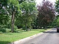
Typical street scene: a quiet and well-kept residential street


See also
- List of streets, squares and bridges in Hamburg-Marienthal
- List of cultural monuments in Hamburg-Marienthal
- List of stumbling blocks in Hamburg-Marienthal
Individual evidence
- ↑ Statistics Office North, Hamburg District Profiles, reporting year 2016, pages 138–139; Data status December 31, 2016 (accessed February 9, 2018)
swell
- Franklin Kopitzsch , Daniel Tilgner (Ed.): Hamburg Lexikon. 2nd, revised edition. Zeiseverlag, Hamburg 2000, ISBN 3-9805687-9-2 .
- Daniel Tilgner (Ed.): Hamburg from Altona to Zollenspieker. The Haspa manual for all districts of the Hanseatic city. Hoffmann and Campe, Hamburg 2002, ISBN 3-455-11333-8 .
- Michael Pommerening, Joachim R. Frank: The Wandsbeker Castle. Mühlenbek publishing house. Hamburg 2004, ISBN 3-9807460-3-8 .
- Michael Pommerening: Wandsbek. A historical tour. Mühlenbek-Verlag, Hamburg 2011, ISBN 978-3-9807460-6-9 .
Web links
- Statistics Office North, Hamburg District Profiles 2016 (as of December 31, 2015)
- [1] Wandsbek (and Marienthal) history workshop
Bergstedt | Bramfeld | Duvenstedt | Eilbek | Farmsen-Berne | Hummelsbüttel | Jenfeld | Lemsahl-Mellingstedt | Marienthal | Poppenbüttel | Rahlstedt | Sasel | Steilshoop | Tonndorf | Volksdorf | Wandsbek | Wellingsbüttel | Wohldorf-Ohlstedt