
Districts in Hamburg
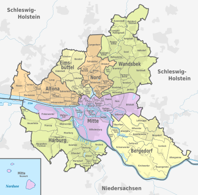
The Free and Hanseatic City of Hamburg , as a state and unified municipality, has been divided into seven districts since 1951, in which district offices are responsible for the independent handling of assigned tasks. The district offices are responsible for a number of decentralized administrative tasks, in particular in the social, health, construction, registration, housing and real estate sectors as well as in the area of economic surveillance. Each district has a district assembly to advise and involve the citizens in administration and district political issues .
The seven districts of Hamburg are subdivided into a total of 104 districts (since January 1, 2011), which consist of one or more districts. City and districts are geographical and statistical, but not political units. The layout of the districts was chosen in such a way that each district includes both urban districts that are densely populated as well as areas farther out on the border.
The districts at a glance
| No. | district | Area in km² |
Population (December 31, 2019) |
Population density (inhabitants per km²) |
Districts | District Office Manager |
|---|---|---|---|---|---|---|
| 1 |
|
142.2 | 301,543 | 2121 | 19th | Falko Droßmann (SPD) |
| 2 |
|
77.9 | 275.264 | 3534 | 14th | Stefanie von Berg (Greens) |
| 3 |
|
49.8 | 267.051 | 5362 | 9 | Kay Gätgens (SPD) |
| 4th |
|
57.8 | 314,593 | 5443 | 13 | Michael Werner-Boelz (Greens) |
| 5 |
|
147.5 | 441.012 | 2990 | 18th | Thomas Ritzenhoff (SPD) |
| 6th |
|
154.8 | 130,260 | 841 | 14th | Arne Dornquast (SPD) |
| 7th |
|
125.2 | 169.426 | 1353 | 17th | Sophie Fredenhagen (independent) |
|
|
755.2 | 1,899,160 | 2515 | 104 |
The districts and their individual subdivisions
City and districts
The districts each consist of several districts , the names and boundaries of which have often evolved over time, some of which are more recent. For statistical purposes, many districts are divided into several districts . The 181 districts of Hamburg (since January 1, 2011) are designated with a three-digit number, the first digit of which stands for the district (example: the Neustadt district in the Hamburg-Mitte district consists of the four districts 105 to 108. The relatively small one The Cranz district in the Harburg district consists of only one district 718, with identical city and district boundaries).
The district with the largest area is Wilhelmsburg (35.3 km²), the smallest is the Sternschanze district, newly formed in 2008 (0.47 km²; previously Hoheluft-Ost with 0.581 km²). The most populous district is Rahlstedt with 86,962 inhabitants (as of 2011), while Altenwerder only has three inhabitants.
In addition to these official subdivisions, there are other historical or more recent names for districts, quarters, quarters, or for larger scenic areas and other geographical units (for example field and island names).
Hamburg-Mitte district


The district of Hamburg-Mitte has 19 districts:
Hamburg-Altstadt ,
Billbrook ,
Billstedt ,
Borgfelde ,
Finkenwerder ,
HafenCity ,
Hamm ,
Hammerbrook ,
Horn ,
Kleiner Grasbrook ,
Neustadt ,
Neuwerk ( exclave ),
Rothenburgsort ,
St. Georg ,
St. Pauli ,
Steinwerder ,
Veddel ,
Waltershof ,
Wilhelmsburg .
Altona district


The Altona district has 14 districts:
Altona-Altstadt ,
Altona-Nord ,
Bahrenfeld ,
Blankenese ,
Groß Flottbek ,
Iserbrook ,
Lurup ,
Nienstedten ,
Osdorf ,
Othmarschen ,
Ottensen ,
Rissen ,
Sternschanze ,
Sülldorf .
Eimsbüttel district


The Eimsbüttel district has 9 districts:
Eidelstedt ,
Eimsbüttel ,
Harvestehude ,
Hoheluft-West ,
Lokstedt ,
Niendorf ,
Rotherbaum ,
Schnelsen ,
Stellingen .
Hamburg-North district


The Hamburg-Nord district has 13 districts:
Alsterdorf ,
Barmbek-Nord ,
Barmbek-Süd ,
Dulsberg ,
Eppendorf ,
Fuhlsbüttel ,
Groß Borstel ,
Hohenfelde ,
Hoheluft-Ost ,
Langenhorn ,
Ohlsdorf ,
Uhlenhorst ,
Winterhude .
Wandsbek district


The Wandsbek district has 18 districts:
Bergstedt ,
Bramfeld ,
Duvenstedt ,
Eilbek ,
Farmsen-Berne ,
Hummelsbüttel ,
Jenfeld ,
Lemsahl-Mellingstedt ,
Marienthal ,
Poppenbüttel ,
Rahlstedt ,
Sasel ,
Steilshoop ,
Tonndorf ,
Volksdorf ,
Wandsbek ,
Wellingsbüttel ,
Wohldorf-Ohlstedt .
Bergedorf district
The three maps do not yet show the new (from January 1, 2011) district of Neuallermöhe.


The Bergedorf district has 14 districts:
Allermöhe ,
Altengamme ,
Bergedorf ,
Billwerder ,
Curslack ,
Kirchwerder ,
Lohbrügge ,
Moorfleet ,
Neuallermöhe ,
Neuengamme ,
Ochsenwerder ,
Reitbrook ,
Spadenland ,
Tatenberg .
Harburg district


The Harburg district has 17 districts:
Altenwerder ,
Cranz ,
Eißendorf ,
Francop ,
Gut Moor ,
Harburg ,
Hausbruch ,
Heimfeld ,
Langenbek ,
Marmstorf ,
Moorburg ,
Neuenfelde ,
Neugraben-Fischbek ,
Neuland ,
Rönneburg ,
Sinstorf ,
Wilstorf .
history

Landlords
Like other free imperial cities , Hamburg was able to win over numerous surrounding villages and cities over the course of history and place them under its sovereignty or manage them jointly with other states. The state territory of the Free Imperial City of Hamburg therefore consisted of the actual urban area (within the city walls and ramparts ) and the so-called land area, i.e. a large number of rural communities, including the outer districts of today's districts Hamburg-Mitte, Hamburg-Nord and Eimsbüttel as well as the so-called forest villages . Most of these rural communities formed a closed state area with the city of Hamburg, but some were also completely outside of the country as exclaves (e.g. the Ritzebüttel office at the mouth of the Elbe). There were also small enclaves , like in the Vierlanden , which, like the city of Bergedorf, were administered jointly with the Free and Hanseatic City of Lübeck before the sovereign rights fell entirely to Hamburg in 1868.
The land area has been divided into land lords since the 15th century , the layout of which has changed several times over the years. When the empire was founded in 1871, the state territory of Hamburg was divided into the following areas:
- the city of Hamburg (old town, new town and - since 1868 - St. Georg)
- the suburb of St. Pauli and 15 suburbs (Rotherbaum, Harvestehude, Eimsbüttel, Eppendorf, Winterhude, Uhlenhorst, Barmbek, Eilbek, Hohenfelde, Borgfelde, Hamm, Horn, Billwerder-Ausschlag, Steinwerder and Kleiner Grasbrook) - these were incorporated into Hamburg in 1894
- the land area , divided into the territorial dominions of the Geestlande , the Marschlande , Bergedorf and Ritzebüttel
With the introduction of the Hamburg city code on January 2, 1924, Bergedorf, Cuxhaven and Geesthacht became independent cities in the Hamburg state and withdrew from the rulers.
At that time, the independent cities of Altona , Wandsbek (both belonging to the Prussian province of Schleswig-Holstein since 1866 ) and Harburg and Wilhelmsburg ( province of Hanover ) did not belong to the Hamburg state territory . These four only came to Hamburg through the Greater Hamburg Act of 1937.
Territorial reforms of the National Socialists

After the Greater Hamburg Act came into force on April 1, 1937, the now significantly enlarged national territory temporarily consisted of five cities (Hamburg, Altona, Harburg-Wilhelmsburg , Wandsbek and Bergedorf), the previous Hamburg rural area and the new Hamburg district , which consisted of 27 formerly Prussian communities was formed.
It was not until the introduction of the German municipal code on April 1, 1938 that Hamburg was formally merged into one municipality and at the same time the administration was separated into a state and a municipal level. At the state level, the urban areas were combined to form a city district and the rural suburbs to form a rural district based on the model of the previous country rule . The latter was subordinate to Police Senator Alfred Richter as "Land Mayor" and included 20 decentralized offices in addition to the main administration.
In addition, the Hamburg urban area was again divided into ten districts a year later, on April 1, 1939, closely following the party structure of the NSDAP , to which 110 "districts" (roughly equivalent to today's districts) and 178 districts were subordinate. This district division anticipated the later district structure in many ways:
| circle | Districts | annotation |
|---|---|---|
| 1 | Lokstedt, Schnelsen, Niendorf, Langenhorn, Fuhlsbüttel, Ohlsdorf, Alsterdorf, Groß Borstel, Winterhude, Eppendorf, Hoheluft (East + West!) | = outer districts of today's districts Eimsbüttel and Hamburg-Nord |
| 2 | Eimsbüttel, Harvestehude, Rotherbaum | = "Core area" of the later Eimsbüttel district |
| 3 | St. Pauli, Neustadt, Old Town, Steinwerder, Waltershof, Finkenwerder | = western area of Hamburg-Mitte |
| 4th | St. Georg, Borgfelde, Hammerbrook, Klostertor, Kleiner Grasbrook, Veddel, Rothenburgsort, Billwerder Ausschlag , Billbrook | = middle area of Hamburg-Mitte |
| 5 | Hohenfelde, Eilbek, Hamm, Horn, Billstedt | = eastern area of Hamburg-Mitte |
| 6th | Barmbek, Dulsberg, Uhlenhorst | = southern area of Hamburg-Nord without Hohenfelde |
| 7th | Altona, Ottensen, Bahrenfeld, Eidelstedt, Stellingen, Groß Flottbek, Othmarschen, Nienstedten, Blankenese, Sülldorf, Rissen, Osdorf, Lurup | = today's Altona district plus Eidelstedt and Stellingen |
| 8th | Wilhelmsburg, Georgswerder, Moorwerder, Harburg, Heimfeld, Eißendorf, Wilstorf, Marmstorf, Rönneburg, Langenbeck, Sinstorf, Neuland, Gut Moor, Moorburg, Francop, Altenwerder, Fischbeck, Neugraben, Cranz, Neuenfelde | = Harburg district within the boundaries from 1951–2006 |
| 9 | Lohbrügge, Bergedorf, Altengamme, Curslack, Kirchwerder, Neuengamme, Allermöhe, Billwerder, Moorfleet, Ochsenwerder, Reitbrook, Spadenland, Tatenberg | = Bergedorf district |
| 10 | Wandsbek, Marienthal, Hinschenfelde, Gartenstadt, Tonndorf, Jenfeld, Bramfeld, Steilshoop, Farmsen, Wohldorf-Ohlstedt, Duvenstedt, Bergstedt, Lemsahl-Mellingstedt, Poppenbüttel, Hummelsbüttel, Wellingsbüttel, Sasel, Volksdorf, Rahlstedt | = Wandsbek district without Eilbek |
After the devastating air raids in July 1943 and the subsequent evacuation of large parts of the population, the worst affected districts 2, 3, 5 and 6 were divided among their neighboring districts. Since local public transport had largely collapsed, 23 decentralized local offices were set up from November 15, 1943 , which were assigned to the respective districts and continued to exist after the end of the war:
- District 1 = Lokstedt, Winterhude, Eppendorf, Eimsbüttel, city center
- District 4 = St. Georg, Billstedt, Barmbek-Nord, Uhlenhorst
- District 7 = Altona, Flottbek-Othmarschen, Stellingen, Blankenese
- District 8 = Wilhelmsburg, Harburg, Süderelbe, Finkenwerder
- District 9 = Bergedorf, Vier- und Marschlande
- District 10 = Wandsbek, Walddörfer, Alstertal, Rahlstedt
District reform 1949

After 1945 the separation into state and municipal administration was abolished again, as were the district administrations with the exception of Harburg and Bergedorf.
On September 21, 1949, the Hamburg citizenship passed the law on district administration in the Free and Hanseatic City of Hamburg , which came into force on May 11, 1951 and created today's seven districts (15 local offices, 106 districts and 179 districts). The basis for the deliberations was an expert opinion submitted to the Senate in 1948, The Reorganization of the Municipal Administration of the Hanseatic City of Hamburg by Oskar Mulert , the former executive president of the German Association of Cities . This envisaged a "sectoral" structure, according to which each district should have areas of the dense inner city as well as less dense outer areas.
The existing local offices and local offices were also subordinated to the newly created district offices . District committees were created in all districts to advise on local political issues and to enable citizens to participate in administration . In 1961 they were renamed district assemblies .
District administration reform 2008
Until February 29, 2008, each district was divided into a core area and one to four local office areas. In the course of the district administration reform, the local offices and local committees were dissolved. As early as February 1, 2007, the district offices were reorganized and the local offices (with the above local office heads) and local offices dissolved. The tasks of the former local offices are now performed by the district offices and regional customer centers, and the former local committees are replaced by regional committees. The law on the spatial structure of the Free and Hanseatic City of Hamburg passed by the Hamburg Citizenship on July 18, 2006 , also brought the following territorial changes into force on March 1, 2008:
- the Wilhelmsburg district moved from the Harburg district to the Hamburg-Mitte district
- The new Sternschanze district was formed from parts of the Hamburg-Mitte, Altona and Eimsbüttel districts and assigned to the Altona district
- In the Hamburg-Mitte district, the new HafenCity district was formed from sub-areas of the Hamburg-Altstadt, Klostertor and Rothenburgsort districts
- the district Klostertor was lifted and the non new port City area associated part was the district Hammerbrookstraße assigned
Further area and district changes since 1949
The Hamburg islands Neuwerk and Scharhörn with part of the Wadden Sea until 1937 (and the later island Nigehörn ) went back to Hamburg in 1969 because of a planned but never built deep water port from the state of Lower Saxony . The area in the mouth of the Elbe was assigned to the district of Hamburg-Mitte as the Neuwerk district. In the mid-1970s there were also minor changes in the Bergedorf district (in the Altengamme district) due to corrections to the state borders of Hamburg, Lower Saxony and Schleswig-Holstein in the area of the Geesthacht barrage .
Apart from the changes made to the districts at the same time as the district administration reform in 2008, the Farmsen district was renamed Farmsen-Berne in 1961 and the Billwerder Ausschlag district in the Hamburg-Mitte district was repealed and assigned to the Rothenburgsort area in 1970 . On January 1, 2011, the districts of Hamm-Nord, Hamm-Mitte and Hamm-Süd in the Hamburg-Mitte district were merged to form the Hamm district (district structure 121-127 remained) and the Neuallermöhe district was created in the Bergedorf district . This is made up of the residential areas Neuallermöhe-Ost (previously part of the Bergedorf district) and Neuallermöhe-West (previously part of Allermöhe). At the same time, the Alt- Nettelnburg settlement from the Allermöhe district was now assigned to the Bergedorf district and a small area on the railway line from the Billwerder district was also transferred to Bergedorf.
Organs of the district administration
In each of the districts there is a district office which, with its various departments, specialist offices and service centers, performs decentralized and local administrative tasks. In the course of the district administration reform, customer centers were set up for citizens at the district offices (or instead of the former local offices) for the duties of the residents' registration office. Some of the social service centers for state transfer and support services and the centers for economic development, construction and the environment are still under construction .
In addition, the specialist authorities (ministries in territorial states) and offices that are subordinate to the Senate also perform municipal tasks in the entire area of the Free and Hanseatic City of Hamburg. The official supervision (district supervisory authority) has been an office of the science authority since 2020 . Before that, until 2020 Office 6 of the tax authority , which was also responsible for other matters of the district administration and which had emerged from the Senate Office for District Affairs, exercised district supervision .
The districts each have a district assembly , which has been directly elected every five years parallel to the European elections since 2014 . The members of the district assemblies are sometimes referred to as “district representatives”, even though they are not members. The head of the administration (the district office ) is the district office manager , who is elected by the district assembly, but requires confirmation from the senate in order to take office.
However, the self-government rights of the districts do not correspond to those of municipalities in other federal states. This is expressed, among other things, in the fact that the district manager needs confirmation from the Senate to take office and that decisions of the district authorities can be overridden by the Senate by evoking the matter in question or by issuing binding individual instructions to the relevant senators .
Web links
- The districts and districts on hamburg.de and map as PDF
- District map and district profiles
- Hamburg's districts in sign language
Individual evidence
- ^ Constitution of the Free and Hanseatic City of Hamburg of June 6, 1952, Article 4 . HmbBL I 100-a ( landesrecht-hamburg.de [accessed on March 18, 2018]).
- ^ Note on the constitution of the Free and Hanseatic City of Hamburg
- ↑ Second implementing ordinance for the law on Greater Hamburg and other territorial consolidations, Section 6
- ^ Michael Rademacher: German administrative history from the unification of the empire in 1871 to the reunification in 1990. Hamburg 1.4.1937–31.3.1938. (Online material for the dissertation, Osnabrück 2006).
- ^ Holger Martens : Hamburg's way to the metropolis. From the Greater Hamburg Question on the District Administration Act , Hamburg 2004, ISBN 3-935413-08-4 , p. 133.
- ^ Holger Martens : Hamburg's way to the metropolis. From the Greater Hamburg Question on the District Administration Act , Hamburg 2004, ISBN 3-935413-08-4 , pp. 130-132.
- ^ Holger Martens : Hamburg's way to the metropolis. From the Greater Hamburg Question on the District Administration Act , Hamburg 2004, ISBN 3-935413-08-4 , p. 136 f.
- ↑ Holger Martens , Hamburgs Weg zur Metropole, p. 143.
- ^ Franklin Kopitzsch , Daniel Tilgner (ed.): Hamburg Lexikon. 2nd, revised edition. Zeiseverlag, Hamburg 2000, ISBN 3-9805687-9-2 , pp. 67-68.
- ^ Daniel Tilgner (ed.): Hamburg from Altona to Zollenspieker. The Haspa manual for all districts of the Hanseatic city. Hoffmann and Campe, Hamburg 2002, ISBN 3-455-11333-8 , p. 44.
- ↑ Senate of the Free and Hanseatic City of Hamburg constituted , Senate Chancellery Hamburg , accessed on June 10, 2020