
Hamburg-Hummelsbüttel
|
district of Hamburg |
|
|---|---|
  |
|
| Coordinates | 53 ° 38 '52 " N , 10 ° 2' 29" E |
| surface | 9.2 km² |
| Residents | 18,394 (Dec. 31, 2019) |
| Population density | 1999 inhabitants / km² |
| Post Code | 22339 |
| prefix | 040 |
| district | Wandsbek |
| Source: Statistical Office for Hamburg and Schleswig-Holstein | |
Hummelsbüttel is a district of Hamburg in the Wandsbek district . Until 2008, Hummelsbüttel belonged together with Poppenbüttel , Sasel and Wellingsbüttel to the Alstertal local authority area .
geography
Hummelsbüttel borders Langenhorn and Fuhlsbüttel in the west, Norderstedt in the north and Poppenbüttel in the east . The southern border is formed by the Alster .
history
The village of Hummelsbüttel was first mentioned in a document in 1319 as the Humersbotle . The place name indicates an earlier existence, as the suffix -büttel refers to a Saxon foundation. A certain Hunmar resident here - a name first mentioned in the 8th century - is accepted as the namesake. For the middle of the 13th century, trading in grain is documented. A Lambertus de Hummersbutle is mentioned in 1253 and 1266. The family of the Knights of Hummelsbüttel were among the most powerful knights in Holstein in the 14th century. From his castle in Stegen , Johann von Hummersbuttel controlled the traffic on the Alster and attacked Hamburg merchants. In 1346 he was one of the knights who rose up against the Counts of Schauenburg and Holstein . In 1349 he lost Hummelsbüttel to the counts, who left the village to the Harvestehude monastery from the 14th to the 16th century .
With the Reformation and the dissolution of the monastery, Hummelsbüttel came to the County of Holstein-Pinneberg in 1528 . When the counts died out in 1640, the village with the Pinneberger rule fell to Denmark, but was part of the Hamburg parish of Eppendorf until the Gottorp settlement of 1768 . Since the 17th century, Hummelsbüttel has moved away from a pure farming village with the establishment of brickworks , which satisfied the increased demand of nearby Hamburg.
.jpg)
.jpg)
In 1841 a Grütz mill was built (on today's Grützmühlenweg) , which ceased operations in 1862. The building was demolished in 1962 and rebuilt in the Volksdorf museum village . With the annexation of Schleswig-Holstein by Prussia in 1867, Hummelsbüttel was incorporated into the newly formed Stormarn district. The introduction of the Prussian municipal constitution in 1889 assigned it to the Poppenbüttel district . In 1937 it was attached to Hamburg due to the Greater Hamburg Act .
Since the 1950s, Hummelsbüttel has experienced a complete change in its previously village structure, especially due to the construction of the large settlements of Lentersweg and Tegelsbarg in the 1970s (partly documented in the Poppenbüttel district ). The last steam brick ceased operations in 1968. Since the construction of the high-rise buildings in the former town center, which is now called Hummelsbüttler Markt, although there has never been a market in Hummelsbüttel, it is hardly recognizable that it was a real farming village. The destruction of two prominent, althummelsbüttler buildings by fires contributed to this. One building was a very elongated thatched-roof house, located on the old village square where the village inn had been. The other was Hummelsbüttel's oldest house from 1672, also with a thatched roof. Today there is only one thatched roof house in Hummelsbüttel, the former shoemaker's cottage in Grützmühlenweg.
The boundary stones that have been preserved from the Danish era are still very striking today. In the streets Gnadenbergweg, Kurzer Kamp, Hummelsbütteler Kirchenweg, Heisterkamp, Ohkamp and along the Raakmoorgraben, the granite steles with the Danish royal coat of arms can be seen, up to 1.20 meters high. A total of 30 stones from the period between 1783 and 1862 have been preserved ( → list ). They mark the former border between the rule of Pinneberg, ruled by the Danish king in personal union as Duke of Holstein, to which Hummelsbüttel belonged, and the Hanseatic City of Hamburg with its rural communities Fuhlsbüttel and Langenhorn.
Picture gallery

View from the garbage dump to the Hummelsbütteler Feldmark and the Hummelsee
Flat roof bungalows as part of the “Parkstadt Hummelsbüttel” ensemble (monument)

Christophorus-Kirche Poppenbüttler Stieg 25, on the left the pastorate (monument)

Grützmühle, stood in Hummelsbüttel until 1962, today in the museum village of Hamburg-Volksdorf
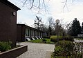
School Poppenbüttler Stieg, formerly Hauptschule and Realschule, now as the third location of the Poppenbüttel district school (background of the tower of the Christophoruskirche)

View from Hummelsbütteler Weg to the west of the Hummelsbütteler Markt shopping center

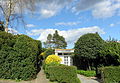
Former school building (now daycare center) Hummelsbüttler Hauptstrasse 105 (monument)
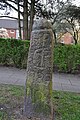
Boundary stone No. 3 of the village of Hummelsbüttel, which formerly belonged to the Pinneberg lordship, today on the border of the districts of Hummelsbüttel and Fuhlsbüttel, inscription: HP / C7 / 1786 / No 3

The Susebek , tributary of the Alster, rises from the Feldmark

Orchard meadow in the Hummelsbüttler Moore nature reserve near Müllberg

Poppenbütteler Weg courtyard (architectural monument)

Abrupt edge in the Sievert clay pit natural monument
.jpg)


.ajb.jpg)

.jpg)

.ajb.jpg)


population
- 1937: 1,900
- 2002: 17,454
- 2004: 17,081
- 2005: 17.057
- 2011: 17,284
- 2012: 17,032
- 2013: 17.051
- 2014: 17,180
- 2015: 17,437
- 2016: 17,655
The population in Hummelsbüttel is made up as follows (data from the North Statistics Office, as of December 2016):
- Minority rate: 17.4%, slightly above the Hamburg average of 16.2%.
- Share of households with children: 21.0%, above the Hamburg average of 17.8%.
- Old age quota: 25.0%, is well above the Hamburg average of 18.3%.
- Proportion of foreigners: 14.3%, is below the Hamburg average of 16.7%.
- Share of benefit recipients according to SGBII (Hartz IV): 10.6%, corresponds approximately to the Hamburg average of 10.3%
- Unemployment rate: 5.1%, roughly equivalent to the Hamburg average of 5.3%.
The average annual income per taxpayer in Hummelsbüttel was around 38,135 euros in 2013, roughly in line with the Hamburg average (39,054 euros).
politics
For the election to Hamburg citizenship , Hummelsbüttel belongs to the Alstertal-Walddörfer constituency . The 2015 state election led to the following result:
- SPD 50.5% (-0.2)
- CDU 18.6% (−6.4)
- FDP 8.3% (+0.1)
- Green 7.1% (+0.4)
- AfD 6.7% (+6.7)
- Left 6.2% (+1.1)
- Remaining 2.6% (-1.7)
Economy and Infrastructure
education
At school Hummelsbuettel at the Hummelsbütteler main road a high school can be stored. The former secondary and secondary school on Poppenbüttler Stieg is now a location of the Poppenbüttel district school . The only elementary school is located on Grützmühlenweg next to the grammar school.
traffic
Hummelsbüttel has no connection to the supra-regional motorway or federal road network . There is also no direct connection to the underground or S-Bahn network. Several stops of the U1, S1 and S11 lines are nearby, but not directly in the district, so the following bus lines cover the district:
- 24 ( Rahlstedt station → U Niendorf Markt ) (Metrobus line)
- 172 ( Mundsburger Brücke → Lentersweg, Hummelsbüttel )
- 174 ( U / S Ohlsdorf → U Volksdorf )
- 178 ( U Garstedt → S Poppenbüttel )
- 179 ( U Borgweg → S Poppenbüttel )
- 193 ( U Garstedt → Lademannbogen (east) / (west) )
- 607 ( S Reeperbahn → S Poppenbüttel ) (night bus)
Culture and sights
In the large housing estate Lentersweg, the IGL interest group around Lentersweg e. V. formed after the settlement was established. The task is to promote urban culture and youth work. After initial problems, IGL has had its own house on Flughafenstrasse since 2010.
On an area of over 8 hectares on the edge of the Hummelsbüttler Feldmark, the non-profit HSN e. V. (Hamburger Sport und Naturismus eV) a natural area where you can relax from everyday stress and do a variety of sports. Club and association members (DFK and INF) have 2 swimming lakes, sports and playgrounds, sunbathing lawns, around 80 parking spaces for caravans, a club house, sanitary facilities (one for the disabled), sauna and youth hut. Non-members can also enjoy a day stay on the premises or use a trial membership for 3 months.
nature

A large part of the Hummelsbüttel area is under protection. These protected areas include:
- The Sievert clay pit natural monument : In the former clay pit in Hummelsbüttel, marine and limnic deposits from the Holstein warm period have been preserved.
- The nature reserves Raakmoor and Hummelsbüttler Moore : Both are connected via the landscape protection area with the NSG Wittmoor in the neighboring district of Lemsahl-Mellingstedt .

- The extensive landscape protection area with the Hummelsbüttler Feldmark: Hummelsbüttel still has a Feldmark that is cultivated by three farmers. It is bordered by the street of Ring 3 in the south, the Raakmoor nature reserve in the west, the large housing estate Tegelsbarg in the east and the border with the Norderstedt district of Glashütte in the north. The Feldmark, the Raakmoor and the former garbage dump in the northernmost tip with the former excavation pond called Hummelsee are landscape protection areas and popular local recreation areas. For the city of Hamburg, the Feldmark is an important cold air channel = flow corridor and biotope connection area. From the 76 meter high mountain you have a view of the skyline from Hamburg to the Harburg mountains and far into the Schleswig-Holstein districts of Segeberg and Stormarn. The coalition agreement between the SPD and the Greens 2015–2020 also expresses the importance of the Feldmark on page 64. In 2016 the Senate decided to lift the landscape protection for part of the Feldmark and to create 364 apartments in 4-storey buildings there.
- The goal of the “Green Future for the Hummelsbüttler Garbage Mountains” initiative, founded in 2013, is to preserve the Feldmark.
- The “Association for the Preservation of Hummelsbütteler Feldmark e. V. ”has set itself the goal of protecting the landscape and the environment, especially in relation to the preservation of the Hummelsbütteler Feldmark. This should be ensured through measures for landscape conservation, through the diversity, individual character and sustainable use of natural resources.
In November 2016, various citizens and associations came together to form the “Hamburg Landscape and Climate Protection Association (HLKV)”. The HLKV is a non-partisan association that campaigns for landscape, environmental, climate and nature conservation - also in Hummelsbüttel. The legal position as an association opens up more possibilities in the dialogue with the Senate and the authorities.

church
The Evangelical Lutheran Christophorus Church was built on the site of Poppenbüttler Stieg 25/29 by the Hamburg architects Hopp and Jäger : first in 1952–1953 the basilica-like nave, 1954 the pastorate opposite, 1954–1955 the solitary tower with a connecting structure and finally in 1966 behind the Church building the free-standing parish hall. The entire complex is listed according to the list of cultural monuments in Hamburg-Hummelsbüttel . Inside the church there is a crucifix and a meditation tablet relief by the sculptor Fritz Fleer (1953), the pulpit and baptismal pedestal as wood inlay by the sculptor Maria Pirwitz (1960), and “Easter candlestick” by Fritz Fleer (1969). Next to the church entrance door on the outer wall is the figure of Christophorus based on the design by Otto Wulk, executed by Neumann, Hamburg (1962). In the community center in the foyer a sculpture by Maria Pirwitz (1973) and in the middle club room a woven tapestry by Max Olderock (1973).
In 1967 the neighboring Evangelical Lutheran retirement and nursing home "Christophorus Haus" was inaugurated.
Sports
In the 1980s, the Hummelsbütteler Sport-Verein played in the Oberliga-Nord, the third-highest German division at the time.
The Oberalster VfW is particularly successful in table tennis . The women's team played in the first Bundesliga (currently Hamburg League ) in the 1970s , the men's team last played in the second Bundesliga in the 2004/05 season (currently in the Oberliga Nord ). The venue is the club's own sports hall on Hermann-Ruge-Weg on the border with Fuhlsbüttel .
The sports fields of the UHC ( Uhlenhorster Hockey Club ) are located in the Alstertal on Alte Landstrasse . The hockey teams regularly play quite successfully for German championships, and tennis tournaments with international participation take place.
See also
- List of streets and squares in Hamburg-Hummelsbüttel
- List of cultural monuments in Hamburg-Hummelsbüttel
- List of stumbling blocks in Hamburg-Hummelsbüttel
literature
- Armin Clasen, Walter Rehders: Hummelsbüttel and Poppenbüttel. Christians, Hamburg 1938.
- Armin Clasen: Hummelsbüttel's borders against Fuhlsbüttel and Langenhorn from the journal of the Association for Hamburg History Volume 52, 1966, pages 55-74 ( digitized version )
- Hans-Gerhard Müller: Dear old Hummelsbüttel. Pictures from days gone by. M + K Hansa Verlag, Hamburg 1980, ISBN 3-920610-36-9 .
- Heinrich Steinfath: Hummelsbüttel - Grützmühle and hall houses - life under the thatched roof. Verlag Otto Heinevetter, Hamburg 1986, ISBN 3-87474-965-7 .
- Festschrift 1953–2003, 50 years of Christophorus Church in Hamburg-Hummelsbüttel , published by the Ev.-luth. Christophorus parish in Hamburg-Hummelsbüttel , Poppenbüttler Stieg 25, 22339 Hamburg.
Web links
- District statistics (PDF file; 3.2 MB) of all Hamburg districts (as of 2013)
- 700 years of Hummelsbüttel on September 7, 2019 on ndr.de ( Hamburg Journal )
Individual evidence
- ↑ Hans Gerhard Risch: The Holstein nobility in the high Middle Ages: A quantitative investigation . Frankfurt am Main 2010, p. 439.
- ^ Statistics Office North, Hamburg District Profiles, reporting year 2016, pages 156–157; Data status December 31, 2016 (accessed February 8, 2018)
- ^ Result of the 2015 state election at www.wahlen-hamburg.de.
- ↑ Interest group Lentersweg e. V.
- ↑ HSN e. V. (Hamburger Sport and Naturism e.V.)
- ^ Ordinance on the Hummelsbütteler Feldmark / Alstertal landscape protection area
- ^ Coalition agreement 2015–2020 of the Hamburg citizenship, 21st legislative period
- ↑ Green future for the Hummelsbüttler garbage mountains
- ^ Association for the Preservation of the Hummelsbütteler Feldmark e. V.
- ↑ Hamburg Landscape and Climate Protection Association (HLKV)
- ↑ Description of the Christophorus House on the operator's homepage. Retrieved February 19, 2016.
Bergstedt | Bramfeld | Duvenstedt | Eilbek | Farmsen-Berne | Hummelsbüttel | Jenfeld | Lemsahl-Mellingstedt | Marienthal | Poppenbüttel | Rahlstedt | Sasel | Steilshoop | Tonndorf | Volksdorf | Wandsbek | Wellingsbüttel | Wohldorf-Ohlstedt