
Hamburg-Eilbek
|
district of Hamburg |
|
|---|---|
  |
|
| Coordinates | 53 ° 34 '4 " N , 10 ° 2' 44" E |
| surface | 1.7 km² |
| Residents | 22,276 (Dec. 31, 2019) |
| Population density | 13,104 inhabitants / km² |
| Post Code | 22087, 22089 |
| prefix | 040 |
| district | Wandsbek |
| Transport links | |
| Federal road |
|
| Regional traffic |
|
| Train |
|
| Subway |
|
| Source: Statistical Office for Hamburg and Schleswig-Holstein | |
Eilbek ( spelling until 1946 : Eilbeck; Low German : Ielbeek , also Eilbeek ) is a district of Hamburg . It is located in the extreme southwest of the Wandsbek district and lies on the Wandse , which bears the name Eilbek there - west of the Maxstraße Eilbek Canal - and flows further into the Outer Alster.
geography

Eilbek is about four kilometers east of Hamburg city center. In the west it borders on Hohenfelde (here the road Wartenau - Landwehr forms the border), in the northwest on the Uhlenhorst , in the north on Barmbek-Süd (along the Eilbek Canal ), in the northeast, at the Friedrichsberg S-Bahn station, on the Dulsberg district , in the east to Wandsbek (route of the Hamburg freight bypass ) and to Marienthal , and in the south to Hamm (the route of the railway line to Lübeck ).
The quarter is mainly characterized by multi-storey residential developments in the post-war style. Only the Auenviertel located in the northwest of the district on the Eilbek Canal (here many street names end in -au such as Blumenau, Eilenau and Hagenau) has a smaller, mostly two-storey development with many old town houses and villas, gardens and lush greenery. There are a few scattered commercial operations, old converted factories and some larger administrative buildings near Hasselbrook train station .
history
-ausschnitt-eilbek-hamm.jpg)


Eilbeck was first mentioned in a document in 1247 as Ylenbeke , which means something like Egelbach . Until the end of the 19th century, leeches were caught here for medicinal use. Eilbek initially belonged to the Hamburg Hospital of the Holy Spirit for around 600 years before the Geestlande ruled in 1830 as part of the reorganization of the Hamburg rural area . The southern border of the Eilbeker Flur originally formed the Heerweg from Hamburg to Lübeck (today's Wandsbeker Chaussee ); the southern part ( Hasselbrook ) belonged to Hamm . In 1856 the area was extended to the south along the Peterskamp to today's Papenstrasse / Pappelallee, and in 1865 finally to the newly built railway line to Lübeck .
After the Great Hamburg Fire in 1842, many of the citizens who had become homeless settled in Eilbek. In 1864 the Friedrichsberg State Hospital , today Schön Klinik Hamburg-Eilbek , was founded. After the construction of the Lübeck railway, the influx of people to Eilbek increased, which was initially elevated to a suburb in 1874 and finally incorporated into Hamburg as a district in 1894.
In 1923 Eilbek was one of the centers of the communist Hamburg uprising .
During the Second World War , Eilbek outside the Auenviertel was almost completely destroyed by the heavy air raids of Operation Gomorrah in July 1943. The buildings that were destroyed included the Hospital of the Holy Spirit and the Maria Magdalenen Monastery in Richardstrasse, both of which were administered by the upper elders.
When Hamburg was reorganized in 1949, Eilbek became part of the Wandsbek district .
Personalities
- In 1928 Hans Fallada lived temporarily in Hasselbrookstrasse (No. 54)
- Vicky Leandros grew up in the Blumenau and attended the Richardstrasse school and what was then the grammar school on the Wartenau
- Otto Lüthje , folk actor at the Ohnsorg Theater , was a full-time teacher at the Roßberg school
- Max Schmeling grew up on Hasselbrookstrasse (No. 14)
- Helmut Schmidt spent part of his youth in Schellingstrasse (No. 9)
population
The Eilbeck population is made up as follows (data from the North Statistics Office, as of December 2016):
- Total population: 21,505 people
- Minor quota: 11.5%, well below the Hamburg average of 16.2%.
- Share of households with children: 11.3%, well below the Hamburg average of 17.8%.
- Old age quota (65-year-olds and older): 15.9%, below the Hamburg average of 18.3%.
- Proportion of foreigners: 14.6%, is below the Hamburg average of 16.7%.
- Share of benefit recipients according to SGBII (Hartz IV): 7.7%, below the Hamburg average of 10.3%
- Unemployment rate: 4.7%, below the Hamburg average of 5.3%.
Eilbek is one of the less affluent districts of Hamburg. The average annual income per taxpayer was around 32,559 euros in 2013 and is lower than the Hamburg average (39,054 euros).
Population development
- 1818: 90
- 1847: 290
- 1874: 5,000
- 1895: 24.611
- 1920: 59.130
- 2000: 19.996
- 2005: 20.011
- 2010: 20,309
- 2015: 21,287
politics
For the election to Hamburg citizenship , Eilbek belongs to the constituency of Wandsbek . The 2015 state election led to the following result:
- SPD 47.5% (-3.4)
- Greens 13.9% (+2.1)
- CDU 11.4% (−6.8)
- Left 8.9% (+2.3)
- FDP 6.2% (+0.4)
- AfD 6.2 (+0.4)
- Other 5.9% (-0.8)
Culture and sights

.3.24542.ajb.jpg)
Churches
Friedenskirche
The Evangelical Lutheran Peace Church was inaugurated in March 1885 as the first independent parish church for Eilbek. It was destroyed in July 1943 and renovated in 1954.
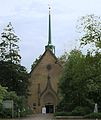
Easter Church
The former cemetery chapel of the Jacobi cemetery was built in 1863-64 according to plans by Alexis de Chateauneuf . After the cemetery was closed and significant war damage was repaired, it was used as a parish church from 1962. In January 2019, the Bulgarian Orthodox community took over the building.
Church of Reconciliation
The construction of the Evangelical Lutheran church took place in 1916-20 according to plans by Fernando Lorenzen , the tower was completed in 1925. Wilhelm Rex made the three reliefs above the entrance in 1921.
Archangel Michael Church
Parks
The Jacobi Park is a 1,954 of abandoned cemetery . It was laid out in 1848 by the main church St. Jacobi at the gates of Hamburg. In 1862 another burial place for the Hammer Dreifaltigkeitsgemeinde was added. Individual tombs are still there.
Two other parks are the Eilbeker Bürgerpark near the Friedenskirche and the Friedrichsberger Park along the Eilbek near the Eilbek hospital , both of which are already in the Barmbeck area.
traffic
Private transport
Eilbeck's main artery is the Wandsbeker Chaussee , which runs in an east-west direction (until 2015 part of federal highway 75 ). Further cross arteries are the Eilbeker Weg in the north, as well as the Papenstrasse and the Hasselbrookstrasse in the south. Important north-south connections are listed from the west: Wartenau / Landwehr , Hirschgraben , Ritterstraße, Kantstraße, Hammer Steindamm .
Public transport
In Eilbek are the S-Bahn stations Landwehr , Hasselbrook , Wandsbeker Chaussee and on the border with Dulsberg the S-Bahn station Friedrichsberg. The regional train line RB81 (Hamburg– Bad Oldesloe ) also stops in Hasselbrook . The underground line 1 also serves Eilbek at the Wartenau , Ritterstraße and Wandsbeker Chaussee stops . This express train service is supplemented by the following bus lines: Metrobus line 25 , which runs along the Landwehr / Wartenau road on the western edge of Eilbeck, express bus lines 35 and 36 , which cross the district on the east-west axis, and finally the city buses on routes 116, 213 and 261. In night traffic , Eilbek is served by night bus routes 606 in the north-south direction and 608 in the east-west direction.
Picture gallery

The Maria-Magdalenen-Kloster in Richardstrasse in a view from 1904

View over the Wandsbeker Chaussee towards St. Georg

Hasselbrook S and Regional Station , former entrance
Easter Church
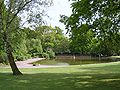
Jacobi-Park: meadow with pond

Jacobi-Park: Grave of Erich Martini (1843–1880) , senior surgeon at the St. Georg AK


Resident companies and authorities
-
AOK main office in Wandsbek
 Entrance to the Seca company at Hammer Steindamm
 - Employment Agency Hamburg-Wandsbek
- Professional association for health services and welfare
- seca gmbh & co. kg.

sports clubs
See also
- List of streets, squares and bridges in Hamburg-Eilbek
- List of cultural monuments in Hamburg-Eilbek
- List of stumbling blocks in Hamburg-Eilbek
literature
- Michael Pommerening, Karl-Heinz Meier: Eilbek in words and pictures . Mühlenbek-Verlag, Hamburg 2008, ISBN 978-3-9807460-4-5 .
- Franklin Kopitzsch , Daniel Tilgner (Ed.): Hamburg-Lexikon. Ellert & Richter, Hamburg 2010, ISBN 978-3-8319-0373-3 , p. 191.
- Daniel Tilgner (Ed.): Hamburg from Altona to Zollenspieker. The Haspa manual for all districts of the Hanseatic city. Hoffmann and Campe, Hamburg 2002, ISBN 3-455-11333-8 , pp. 292-299.
Individual evidence
- ↑ The border used to run along Brauhausstrasse and Hammer Strasse to the so-called "Grenzknick"; Until the 1980s, the border between Hamburg and Prussia was marked here in the pavement .
- ^ Horst Beckershaus: The names of the Hamburg districts. Where do they come from and what they mean . Hamburg 1998, p. 35.
- ^ Daniel Tilgner (ed.): Hamburg from Altona to Zollenspieker. The Haspa manual for all districts of the Hanseatic city. Hoffmann and Campe, Hamburg 2002, ISBN 3-455-11333-8 , p. 293.
- ↑ Hamburg's oldest foundation , hzhg.de, accessed on February 19, 2016.
- ^ Memorial plaque to Hans Fallada at the Hasselbrookstrasse house. 54.
- ↑ Eilbek in Wort und Bild, Hamburg 2008, p. 155.
- ↑ Eilbek in Wort und Bild, Hamburg 2008, p. 153.
- ↑ Memorial plaque to Max Schmeling at the Hasselbrookstr. 14th
- ↑ Helmut Schmidt u. a .: Childhood and youth under Hitler. Berlin 1992, p. 193.
- ↑ Statistics Office North, Hamburg District Profiles, reporting year 2016, pages 134–135; Data status December 31, 2016 (accessed February 9, 2018)
- ↑ a b c Hamburg Lexicon . Ellert & Richter, Hamburg 2010, ISBN 978-3-8319-0373-3 , pp. 191 .
- ^ A b Hermann Hinrichsen: The past from Eilbek and Hohenfelde. M + K Hansa-Verlag, Hamburg approx. 1981, ISBN 3-920610-49 , p. 25.
- ↑ Data from 2000-2015 from the North Statistics Office, databases population Hamburg / districts
- ↑ www.wahlen-hamburg.de
- ↑ The Easter Church is handed over to the Bulgarian Orthodox community. In: kirche-hamburg.de. Retrieved January 27, 2019 .
- ↑ Adolf Diersen: From the history of the hammer Dreifaltigkeitskirche. Holzminden 1957, p. 31.
Web links
- District statistics (PDF; 3.4 MB) of all Hamburg districts (as of 2010)
Bergstedt | Bramfeld | Duvenstedt | Eilbek | Farmsen-Berne | Hummelsbüttel | Jenfeld | Lemsahl-Mellingstedt | Marienthal | Poppenbüttel | Rahlstedt | Sasel | Steilshoop | Tonndorf | Volksdorf | Wandsbek | Wellingsbüttel | Wohldorf-Ohlstedt