
Hammer stone dam

The Hammer Steindamm is an approximately 2 km long inner-city street in the Hamburg districts of Eilbek and Hamm . It is part of the main road network of Hamburg , has the official key number H084 and runs in the postcode areas 22089 (Eilbek) and 20535 (Hamm).
Name and story
-ausschnitt-eilbek-hamm.jpg)
Hammer Steindamm owes its name (like Steinstraße and other stone dams and paths in Hamburg) to the fact that it was the first street in the area to be paved as early as 1835 . This in turn points to the early economic importance of this connection for: On historical maps it is at least since the 18th century as "Möhlenweg " reported that on the eastern edge of the marshy Hasselbrook went and on Geesthang situated village Hamm with the mills in Eilbek (Windmill on the Roßberg) and Wandsbek ( Rantzausche watermill on the Wandse ).

The street got its current name and course in 1856, when Eilbek, north of the newly built railway line to Lübeck , was developed and built up to the then city limits to Wandsbek. On the Hammer side, on the other hand, the Steindamm formed the outer development boundary until the First World War, while the eastern field mark on the other side of the street was not built on until the 1920s and 1930s.
During the Second World War , Eilbek and Hamm were badly destroyed in Allied air raids , so that today the street is characterized by a mixed development with residential and commercial buildings from different eras.
Course and development


Hammer Steindamm begins in the north on Wandsbeker Chaussee ( Lage ) and initially runs south to Hasselbrook station , where it crosses the tracks of the Lübeck Railway and the S-Bahn to Ohlsdorf and Poppenbüttel . On the west side, this section is mainly built up with four-story residential buildings from the 1950s, while on the east side there is an industrial park in which, among other things, the traditional scales and medical technology manufacturer seca is located.

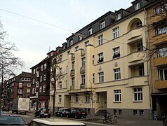
To the south of the railway line, the Steindamm bends slightly to the southwest, while the Caspar-Voght-Strasse branches off here in a southeastern direction. This area is dominated on the east side by four- to six-storey brick apartment blocks from the 1920s, while on the west side there is a comparatively low post-war development with shops and small businesses. In the further course, residential and commercial buildings from the pre-war and post-war period alternate with some new buildings from recent years. The end of this middle section is the elongated three-wing building of the former Kirchenpauer grammar school, which was built in 1928–30 based on a design by Heinrich Bomhoff and Hermann Schöne and today houses the North German Academy for Finance and Tax Law .

At the financial school, the Hammer Steindamm crosses the Sievekingsallee running out of town and from here runs along the western border of the Hammer Park . On the opposite (western) side of the street a few houses have received from the period before the First World War, but also the " Henry-Everling -Hof", a striking brick apartment block of the previous consumer, construction and savings association "production" of the year 1925 (today owned by the building cooperative of free trade unionists ). To the south there are tennis courts of the sports clubs HT 16 and SV St. Georg on both sides of the street . A stumbling stone in front of the SV St. Georg clubhouse reminds of the former soccer goalkeeper Hermann Kath, who was sentenced to death by a military court for desertion shortly before the end of the Second World War and on April 20, 1945 - a few days before the liberation of Hamburg by British soldiers Troops - Holtigbaum was shot at the firing range.
At the southern end of the tennis courts, the intersection with Carl-Petersen-Strasse and Bei der Hammer Kirche has been developed as a roundabout ; The Hirtenstrasse, which used to flow here, now ends as a dead end. Before the construction of the subway to Billstedt in the 1960s, the Hammer Steindamm ended here on the Geesthang, and the traffic to the Hammer Landstraße , which runs below the slope, was then routed via the Hirtenstraße or the street Bei der Hammer Kirche. But because this had to be shortened for the new Hammer Kirche underground station , the Hammer Steindamm has since then run behind the roundabout in a wide arc around the underground station down the Geesthang and joins Hammer Landstrasse below the Dreifaltigkeitskirche ( location ). In this section, the Hammer Steindamm is also used by the HVV bus routes 116 and 530; In addition , the Veloroute 8 to Billstedt and Bergedorf, which runs in a green corridor on the Geest slope, crosses here .
Local public transport

The Hammer Steindamm is - apart from the Steintorwall at the main station - the only street in Hamburg that is touched by three different S- and U-Bahn lines: In the far north is the U-Bahn station Wandsbeker Chaussee ( U1 ) with its western exit at Hammer Steindamm , in the middle the Hasselbrook train station (S1 / S11 and RB81), in the south the Hammer Kirche underground station ( U2 / U4 ). The Hammer Steindamm stop of bus line 261 is at the Sievekingsallee intersection , and line 116 also runs on the northern and southern sections of Hammer Steindamm.
Individual buildings

New building no. 72–74

" Hamburger Burg ", No. 76–84

New building No. 102
1920s apartment buildings, No. 115–117

Former grammar school, No. 129

"Henry-Everling-Hof", No. 118–120 (here view from the end of the moor)


.JPG)
.6.29219.ajb.jpg)


Web links
swell
- ^ Statistics Office North: Street and area index of the Free and Hanseatic City of Hamburg
- ↑ G. Herman Sieveking , according to the "Mölenendung" is actually "probably the oldest path in the area", cf. The history of the Hammerhof, Part 1, Hamburg 1899, p. 35.
- ↑ Horst Beckershaus: The Hamburg street names. Where do they come from and what they mean. European Publishing House, Hamburg 2011, ISBN 978-3-86393-009-7 , p. 145 .
- ↑ Entry on stumbling blocks in Hamburg. Retrieved May 15, 2020 .