
Bike routes in Hamburg

The Hamburg cycle route network has been planned since the 1990s and has been gradually expanded since then. It consists of twelve star-shaped routes that connect downtown Hamburg ( Rathausmarkt ) with the outer districts, as well as two ring routes . The bike routes are used for fast work and everyday traffic and should therefore be easy to use in all weather conditions and even in the dark. As a rule, they run away from the main roads, through 30 km / h zones , cycle streets or on specially developed cycle paths . By 2020 the network is to be expanded to a total length of 280 km and uniformly signposted.
The cycle route network is supplemented by 15 so-called leisure routes with a total length of 400 km. These are mainly used for excursion and recreational traffic and therefore mostly follow green areas and rivers and connect them with allotment gardens, cemeteries, parks and other recreational areas. They are also linked to national long - distance cycle routes such as the Elbe Cycle Route or the North Sea Cycle Route.
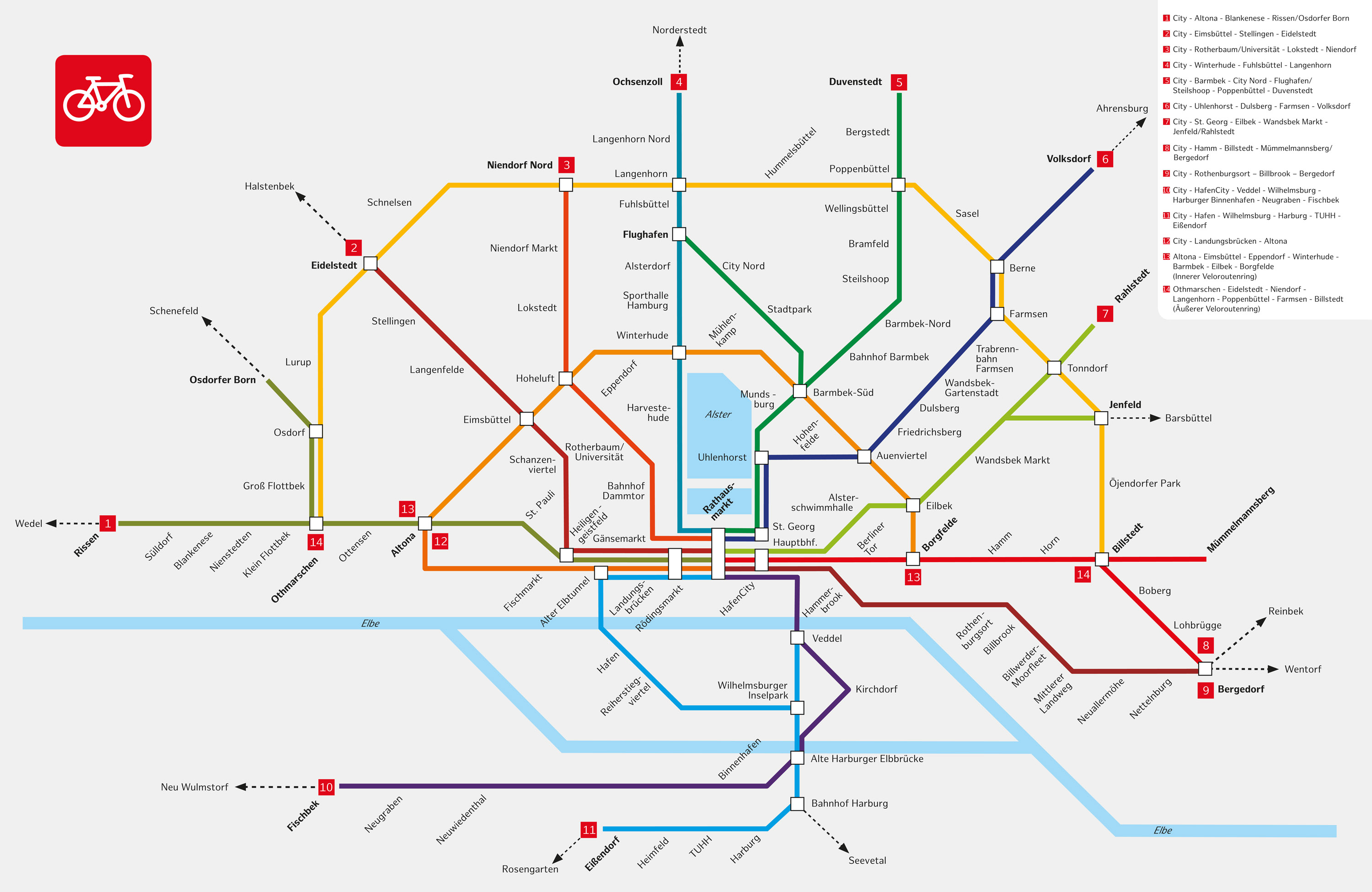
Bike routes (red marking)

The course of the bike routes is marked by signposts with destination and distance information as well as route numbers.
- Route 1: City - Altona - Othmarschen - Blankenese - Rissen
- Route 2: City - Eimsbüttel - Stellingen - Eidelstedt (11 km)
- Route 3: City - Rotherbaum / Uni - Niendorf (13 km)
- Route 4 : City - Harvestehude - Winterhude - Alsterdorf - Fuhlsbüttel - Langenhorn (18.5 km)
- Route 5 : City - Uhlenhorst - Barmbek - Bramfeld - Poppenbüttel - Duvenstedt (23 km)
- Route 6 : City - Hohenfelde - Dulsberg - Farmsen - Berne - Volksdorf (20 km)
- Route 7: City - St. Georg - Eilbek - Wandsbek-Markt - Jenfeld - Rahlstedt
- Route 8: City - Borgfelde - Hamm - Billstedt - Bergedorf (with a branch to Mümmelmannsberg )
- Route 9: City - Hammerbrook - Rothenburgsort - Moorfleet - Allermöhe - Bergedorf (19 km)
- Route 10: City - HafenCity - Veddel - Wilhelmsburg - Harburg - Neugraben (25 km)
- Route 11: City - Alter Elbtunnel - Wilhelmsburg - Harburg - TU Hamburg
- Route 12: City - St. Pauli Landungsbrücken - Altona (5 km)
- Route 13 (Inner Ring Route): Altona - Eimsbüttel - Winterhude - Barmbek - Eilbek - Hamm (14 km)
- Route 14 (outer ring route): Othmarschen - Schnelsen - Niendorf - Poppenbüttel - Billstedt (42 km)
Source: overview map of cycle routes
Leisure routes (green marking)
- FR0: "1. Grüner Ring "(= Wallring , approx. 7 km)
- FR1: Alster (33 km)
- FR2: Osterbek (24 km)
- FR3: Wandse (19 km)
- FR4: Bille (37 km)
- FR5: Vier- und Marschlande (36 km)
- FR6: Elbbrücken (23 km)
- FR7: Harburg Mountains (13 km)
- FR8: banks of the Elbe (17 km)
- FR9: Klövensteen (25 km)
- FR10: Kollau (17 km)
- FR11: "2. Green Ring "(100 km)
- FR12: Tarpenbek (17 km)
- FR13: " Third Mile " (20 km)
- FR14: Old Elbe Tunnel (18 km)
Source: overview plan of leisure routes
See also
- Loop (Hamburg) - leisure round course in Wilhelmsburg
Web links
- Overview of bike routes on hamburg.de
- Overview of leisure routes on hamburg.de
- Background information on the cycling strategy of the Free and Hanseatic City of Hamburg
Individual evidence
- ↑ Elisabeth Jessen: Cycle paths - what is ready and what is still missing. In: Hamburger Abendblatt , August 29, 2019, p. 10 ( abendblatt.de ).
- ↑ Overview map of bike routes (JPG). In: hamburg.de. Retrieved November 18, 2019.
- ↑ Hamburg's leisure routes: By bike through the Hamburg green (PDF) In: hamburg.de . Retrieved November 17, 2019.