
Tarpenbek


|
Tributaries and hydraulic structures
|
|||||||||||||||||||||||||||||||||||||||||||||||||||||||||||||||||||||||||||||||||||||||||||||||||||||||||||||||||||||||||||||||||||||||||||||||||||
The Tarpenbek is a brook in South Holstein and Hamburg . It has its origin in Norderstedt , where the streams Tarpenbek-Ost and Tarpenbek-West flow together. At Ochsenzoll , the Tarpenbek reaches Hamburg-Langenhorn and flows in the direction of Hamburg Airport , the runways of which it both crosses. Then it receives a flow of the Kollau in Groß Borstel . Shortly before it flows into the Alster at Hayns Park , the Tarpenbek in Hamburg-Eppendorf is dammed up to form the Eppendorfer mill pond.
It is 10 km long, the two source rivers are 5 and 6 km long, making the total length of 21 km.
Origin and sources
The Tarpenbek has two source rivers: the Tarpenbek-Ost and the Tarpenbek-West. These flow together in the Tarpenbek Park in Norderstedt. There is an information board at the confluence. You can cross the confluence over a bridge. In addition, a suspension bridge called Tampenbrücke , which is intended for children, leads over the confluence. In the Tarpenbek-Park there is also a “circular route in the Tarpenbek-Niederung”. The Tarpenbek-Ost rises west of Glasmoorstraße on private property next to the Hoheneichen stable. It mainly flows through agricultural areas, which is why you can rarely walk along it. It only crosses under a single public pedestrian bridge near the Jägerlauf. It crosses under Poppenbütteler Strasse, the Kreuzweg and Schleswig-Holstein-Strasse. In a document published by the City of Hamburg in 1996 it is also stated that the Tarpenbek-Ost has the tributary “Ossenmoorgraben”, but it can be clearly seen on site that this ditch flows into the Tarpenbek as a whole.
According to a document from the City of Hamburg from 1996, the Tarpenbek-West, which is usually simply called Tarpenbek, rises in the wild moor north of the street “Alter Kirchweg”. In fact, a bog is not recognizable on site, rather the area resembles a pond. In addition, the Tarpenbek-West has dried out completely about 100 meters before the "moor". The river bed can still be seen here. The park north of the street “Alter Kirchenweg” is freely accessible. In some places a small amount of water can still be seen. According to Wikimedia Cloud Services and Google Maps, where the Tarpenbek-West is not named, the Tarpenbek-West comes from a lot further away, namely from a retention basin south of the Moorweg, near the Norderstedter Stadtpark. Otherwise the Tarpenbek-West has some offshoots shortly before the confluence with the Tarpenbek-Ost. It crosses under the forest path, the Deckerweg and finally the street “Alter Kirchenweg”, where it is almost completely dry. In contrast to Tarpenbek-Ost, you can walk along large parts of the Tarpenbek-West.
Expansion measures
- 1263 damming of the Eppendorfer mill pond
- 1930–1932 Artificial straightening of Hayns Park up to the area of today's airport
- 1955 Pipework to cross under the runway of the airport
- 1990s renaturation of the section to the west of the airport as a compensatory measure for the construction of the area around Fuhlsbüttler
Origin of name
The oldest documented mentions of the water are Terueke (1245 and 1263), Terveke (1266) and Terweke (1325), which developed via Tarwe to Tarpe ; the secondary basic word nd. bek for "Bach" was added late. The meaning of the original name is not clear.
As namesake
The following streets were named after the Tarpenbek:
- On the banks of the Tarpen (runs parallel to the Tarpenbek)
- Tarpen (crosses the Tarpenbek)
- In de Tarpen (continuation of the Tarpen road )
- Tarpenring (ring road on the Tarpen road )
- Tarpenstieg (near the Tarpenbek on the Tarpen road )
- Tarpenbekstraße (Norderstedt, ends at the Tarpenbek)
- Tarpenbekstraße (Hamburg, B433 , runs near the Eppendorfer mill pond )
In addition, some other places near the Tarpenbek bear the name Tarpenbeker Ufer or other names related to the Tarpenbek.
gallery

The Kollau flows into the Tarpenbek
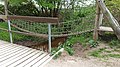
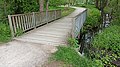
Rope bridge over the confluence / origin of the Tarpenbek

The Tarpenbek as a border river between Hamburg and Norderstedt.
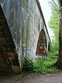
Freight bypass bridge

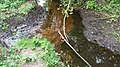
Dried up river bed of the Tarpenbek-West
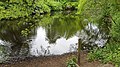
"Wildes Moor" at the original source of the Tarpenbek-West
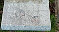
Information sign at the confluence of Tarpenbek-Ost and Tarpenbek-West

Dried up river bed of the Tarpenbek-West
Foothills of the Tarpenbek-West at a bridge just before the confluence

Mouth of the Ossenmoorgraben in the Tarpenbek

Tarpenbek Ost shortly before its source on private property
Confluence of the Tarpenbek Ost (left) and Tarpenbek-West (right) into the Tarpenbek as a whole (above)
Remains of water from the Tarpenbek-West shortly before the "Wild Moor"


Individual evidence
- ^ German Hydrological Yearbook Elbe Region, Part III 2014. (PDF) ISSN 0949-3654. Free and Hanseatic City of Hamburg, Hamburg Port Authority, p. 154 , accessed on October 4, 2017 (German, at: dgj.de).
- ↑ Ute Grezuweit: The Tarpenbek - A flowing water in Hamburg. 1996, accessed August 9, 2020 .
- ↑ Wikimedia Cloud Services, signs on site
- ^ Franklin Kopitzsch, Daniel Tilgner (ed.): Hamburg Lexikon . 2nd, revised edition. Zeise Verlag, Hamburg 2000, ISBN 3-9805687-9-2 , p. 482 , col. 2 .
- ↑ Wolfgang Laur : The names of places and waters of the Free and Hanseatic City of Hamburg , Neumünster 2012, p. 232.