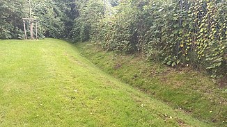
Bornweggraben
| Bornweggraben | ||
|
Second section of the Bornweg ditch |
||
| Data | ||
| location | Hamburg-Niendorf | |
| River system | Elbe | |
| Drain over | Tarpenbek → Alster → Elbe → North Sea | |
| source | At Vogt-Cordes-Damm 53 ° 36 '52 " N , 9 ° 57' 21" E |
|
| muzzle | on the street Bekstück in an R-Siel
|
|
| length | 640 m | |
| Big cities | Hamburg | |
| Navigable | No | |
| Runoff over the Tarpenbek | ||
|
First section of the Bornweggraben |
||
The Bornweggraben is a (total) approx. 650 meter long ditch in Hamburg-Niendorf .
It is divided into two sections, both of which flow into the rainwater channel (R-channel). The ditch belongs to the Tarpenbek catchment area .
course
The first part begins at Vogt-Cordes-Damm, then runs openly towards the south to Papenreye and there flows into an R-Siel.
The second part begins at the Mechthildeweg, runs through a retention basin and flows into an R-Siel at the street Bekstück.
Individual evidence
- ↑ a b Complete list of rivers in the Elbe catchment area. Retrieved June 30, 2020 .
- ↑ card Bornweggraben north Papenraye. Retrieved August 5, 2020 .
- ↑ Bornweggraben on Google Maps. Retrieved August 5, 2020 .

