Brookkampgraben
|
Brookkampgraben Broockkampgraben, Brookkampsgraben |
||
|
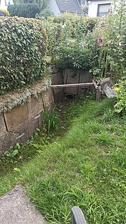
Brookkampgraben as a road ditch on Broockkampsweg |
||
| Data | ||
| location | Hamburg-Niendorf | |
| River system | Elbe | |
| Drain over | Tarpenbek → Alster → Elbe → North Sea | |
| source | On Broockkampsweg near Fuhlsbütteler Weg 53 ° 37 ′ 37 ″ N , 9 ° 57 ′ 51 ″ E |
|
| muzzle | on Siebensternweg on the border with Hamburg-Fuhlsbüttel in the Tarpenbek coordinates: 53 ° 37 '24 " N , 9 ° 58' 11" E 53 ° 37 '24 " N , 9 ° 58' 11" E
|
|
| length | 620 m | |
| Big cities | Hamburg | |
| Navigable | No | |
The Brookkampgraben is a 620 meter long trench in Hamburg-Niendorf . It flows into the Tarpenbek at the airport fence .
course
It runs along Broockkampsweg as an open ditch to house number 26 to the east. From there it continues piped to the southeast, from the height of Karl-Gustav-Weg 17b largely open to Tarpenbek.
According to Google Maps, there is a side ditch which is also connected to the Tarpenbek.
Individual evidence
- ↑ Complete list of rivers in the Elbe catchment area. Retrieved June 30, 2020 .
- ↑ Brookkampsgraben map. Retrieved August 5, 2020 .
- ↑ see Google Maps
