Bille
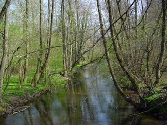
The Bille ( Slavic biely = "white", compare the river name Biela ) is a tributary of the Elbe in northern Germany. It rises north of the Hahnheide near Trittau in the southeast of Schleswig-Holstein and flows into the Lower Elbe in Hamburg .
The Bille is 65 kilometers long, 42 kilometers of which run through Schleswig-Holstein, the rest through Hamburg.
course


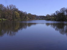
The official source of the Bille is near Linau , south of Sirksfelde and is fed from the Koberger and Linauer Moor. In its upper reaches, the Bille absorbs many streams and small bodies of water. From Grande , Kuddewörde it forms the western border of the Sachsenwald . At Witzhave the Bille takes up the Corbek , at Aumühle the Schwarze Au , which drains large parts of the Sachsenwald. Then it flows through villa areas in Wohltorf . In Reinbek , the Bille zum Mühlenteich is dammed, on the banks of which the Reinbek Castle is located.
The Obere Bille to Bergedorf forms the border between the Stormarn and Lauenburg districts in many places , which in turn corresponds to the historical border between the settlement areas of Saxony and Wenden ( Limes Saxoniae ). In some places this has led to the formation of twin communities, for example there is a Lauenburg and a Stormarn part of Hamfelde and Köthel , just as Grande and Kuddewörde are only separated from the Bille, and the Grander Mühle is actually in Kuddewörde.
In the border area between Aumühle and Krabbenkamp , the river was moved around 100 meters to the south over a length of several 100 meters when the Hamburg – Berlin railway line was built . The old course of the river can still be seen today in some fish ponds to the north of the route.
The Bille has been dammed in Bergedorf since 1208. The dam is at the level of Alte Holstenstrasse. The stately grain water mill was operated here until 1939. At the same time, the dammed water was used for the castle moat. The water level of the upper Bille is regulated here by a weir and drained through the Bergedorf harbor, which is named Serrahn.
Since 1443, the water of the Bille has been flowing through the canalized lock ditch at the Krapphof lock into the Dove Elbe . The original course of the river was built over with the Bergedorf or Lohbrügger city center. The Brookwetterung flows into the lock trench from the east and drains the northern part of the Vierlande .
Parts of the water in the lock trench are channeled over the creek- like, partially cased Kampbille to the Mittleren Bille , which from Heckkaten follows the original course of the river through the Billwerder Marsch to Tiefstack , taking in some of the surrounding waters, such as the Ladenbek and Glinder Au . From the inflow of the Ladenbek to the crossing under the Federal Motorway 1 , the Bille forms the southeast, southern and southwestern edge of the Boberger Niederung nature reserve .
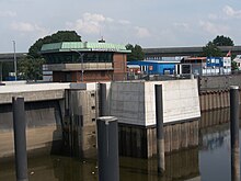
The course of the river, known as Untere Bille from the A1 motorway , branches into various canals in the Hamburg districts of Billbrook , Hammerbrook and Rothenburgsort , which are very much characterized by trade and industry, and ultimately flows into the Elbe at the Brandshofer Schleuse .
Buildings
- Grander mill
- Reinbek Castle
- Bergedorf Castle
- The Serrahn in Bergedorf
- Brandshofer lock
Between Bergedorf and Brandshofer Schleuse, the Bille is crossed by several bridges, the railing color of which was supposedly chosen to make it easier for the mostly illiterate rural population to find their way around. These are (downstream) the - Red Bridge - Yellow Bridge - Blue Bridge - Brown Bridge - Green Bridge - Black Bridge. Old maps show that some of the bridge names date back to at least the 18th century.
Nature reserves
Billetal
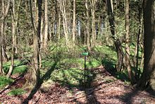
The Billetal between Grander Mühle and its confluence with the Reinbeker Mühlenteich has been a nature reserve since 1987 . Endangered fish species such as grayling , brook lamprey , minnow and brook loach have now resettled there. Brown trout and rainbow trout are relatively common. Rare birds such as the kingfisher nest in the bank area . The Corbek estuary is also part of the nature reserve .
Boberger valley
The Boberger Niederung nature reserve is located north of the Bille in Hamburg between Bergedorf and Kirchsteinbek . It received its protection status in 1991 with a total area of 350 hectares.
Geologically, the area is an ice age meltwater channel system that was created on the southern edge of the icing limit of the last ice age.
literature
- Hartwig Fiege: Castles and palaces on the Bille . In: Lichtwark booklet No. 57. Ed. Lichtwark Committee, 1992. See now: Verlag HB-Werbung, Hamburg-Bergedorf, 2003. ISSN 1862-3549 .
- Berndt Fischbeck: Meine Bille - From the source to the Elbe . artbefi Selbstverlag, Reinbek, 2016. ISBN 978-3-00-052285-7 .
- Hermann Hinrichsen: The Bille with its Hamburg neighborhoods. Changes in an old river idyll , Hamburg 1982.
Web links
- Die Bille, report from the Voluntary Ecological Year 1999/2000, Hamburg Environment Agency (PDF 2.65 MB)
- Geotouristic information about the Bille valley ( Memento from February 11, 2013 in the web archive archive.today )
Individual evidence
- ↑ a b The Elbe from the Geesthacht weir to the confluence with the North Sea ( Memento from March 7, 2016 in the Internet Archive ) (PDF; 6.4 MB); Retrieved April 22, 2011
- ^ German Hydrological Yearbook Elbe Region, Part III 2014. (PDF) ISSN 0949-3654. Free and Hanseatic City of Hamburg, Hamburg Port Authority, p. 149 , accessed on October 4, 2017 (German, at: dgj.de).
- ↑ Umweltdaten.landsh.de (PDF; 935 kB); Retrieved April 22, 2011


