
Linau
| coat of arms | Germany map | |
|---|---|---|

|
Coordinates: 53 ° 39 ' N , 10 ° 28' E |
|
| Basic data | ||
| State : | Schleswig-Holstein | |
| Circle : | Duchy of Lauenburg | |
| Office : | Secondary sand nuts | |
| Height : | 66 m above sea level NHN | |
| Area : | 9.66 km 2 | |
| Residents: | 1252 (Dec. 31, 2019) | |
| Population density : | 130 inhabitants per km 2 | |
| Postal code : | 22959 | |
| Area code : | 04154 | |
| License plate : | RZ | |
| Community key : | 01 0 53 085 | |
| LOCODE : | DE 55U | |
| Office administration address: | Am Amtsgraben 4 23898 Sandesneben |
|
| Website : | ||
| Mayor : | Jürgen Griese ( CDU ) | |
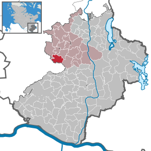
| Location of the municipality of Linau in the Duchy of Lauenburg | ||
  |
||

Linau is a municipality in the Duchy of Lauenburg in Schleswig-Holstein .
geography
Linau lies on the edge of the Hahnheide nature reserve .
The community consists of the villages of Bollweg, Diekkaten, Feilberg, Flachsröte, Linau, Linaubusch and Vogelfängerkaten.
history
1230, the Slavic place was founded in Ratzeburg tithe register the first time as Linowe mentioned. The place name goes back to Old Polish * Linov and is a formation of * lin "tench" and the possessive suffix - ov and means settlement with the tench. Accordingly, Linau is an old fishing village. In 1291 and 1349 the once important Linau castle was destroyed by the robber baron Scarpenbergh , remains can still be seen today. In 1471, Volrad von Scharpenberg finally sold the castle and village to Duke Johann IV of Saxony-Lauenburg . When the districts were formed in 1889, the community and what was then the estate belonged to the Koberg district . After the Second World War, the community first came to the Wentorf Office and after its dissolution to the Sandesneben Office .
politics
Community representation
Of the eleven seats in the municipal council, the CDU has had all eleven since the 2018 local elections
Mayor is Jürgen Griese (CDU).
coat of arms
Blazon : "A silver wavy strip in red, accompanied at the top by two superimposed silver tench, at the bottom by an arrowhead (beam) placed obliquely to the left and divided four times by silver and black."
photos

Remains of Linau Castle

Billequelle near Linau


Web links
Individual evidence
- ↑ North Statistics Office - Population of the municipalities in Schleswig-Holstein 4th quarter 2019 (XLSX file) (update based on the 2011 census) ( help on this ).
- ↑ H. Haefs: Place names and place stories in Schleswig-Holstein: in addition to the rich Slavic place name material and the Danish influences on Fehmarn and Lauenburg, Helgoland and North Friesland: from which comments on the state history result. Norderstedt 2004, p. 155.
- ↑ Schleswig-Holstein's municipal coat of arms
Albsfelde | Alt-Mölln | Aumühle | Bäk | Blue | Basedow | Basthorst | Behlendorf | Berkenthin | Besenthal | Bliestorf | Exchanges | Borstorf | Breitenfelde | Bröthen | Brunsmark | Brunstorf | Books | Buchholz | Buchhorst | Dahmker | Dalldorf | Dassendorf | Düchelsdorf | Duvensee | Single house | Elmenhorst | Escheburg | Fitzen | Fredeburg | Fuhlenhagen | Geesthacht | Giesensdorf | Göldenitz | Goddess | Grabau | Grambek | Grinau | Big floor | Great Disnack | Groß Grönau | Great Pampau | Great Sarau | Groß Schenkenberg | Grove | Gudow | Gülzow | Bream | Hamfelde | Hamwarde | Harmsdorf | Havekost | Hohenhorn | Hollenbek | Hornbek | Horst | Juliusburg | Kankelau | Kasseburg | Kastorf | Kittlitz | Klein Pampau | Klein reveler | Plumbing | Klinkrade | Koberg | Kollow | Koethel | Kröppelshagen-Fahrendorf | Krukow | Curved mass | Krüzen | Kuddewörde | Killing | Kulpin | Labenz | Langenlehsten | Lankau | Lance | Lauenburg / Elbe | Clay wheel | Linau | Lüchow | Lütau | Mechow | Möhnsen | Mölln | Mill wheel | Must | Mustin | Niendorf ad St. | Niendorf near Berkenthin | Nuts | Panting | Pogeez | Poggensee | Ratzeburg | Ritzerau | Römnitz | Rondeshagen | Roseburg | Sahms | Salem | Sandesneben | Schiphorst | Schmilau | Schnakenbek | Schoenberg | Schretstaken | Schulendorf | Poking soles | Schwarzenbek | Seedorf | Seven trees | Seven oaks | Sierksrade | Sirksfelde | Steinhorst | Sterley | Stump | Talkau | Tramm | Walksfelde | Wangelau | Wentorf (Amt Sandesneben) | Wentorf near Hamburg | Wiershop | Witzeeze | Wohltorf | Woltersdorf | Worth | Ziethen
Community-free area in the Duchy of Lauenburg
Sachsenwald district