
Hamfelde (Lauenburg)
| coat of arms | Germany map | |
|---|---|---|
_Wappen.png)
|
Coordinates: 53 ° 36 ' N , 10 ° 27' E |
|
| Basic data | ||
| State : | Schleswig-Holstein | |
| Circle : | Duchy of Lauenburg | |
| Office : | Schwarzenbek country | |
| Height : | 40 m above sea level NHN | |
| Area : | 3.47 km 2 | |
| Residents: | 500 (Dec. 31, 2019) | |
| Population density : | 144 inhabitants per km 2 | |
| Postal code : | 22929 | |
| Area code : | 04154 | |
| License plate : | RZ | |
| Community key : | 01 0 53 049 | |
| Office administration address: | Gülzower Strasse 1 21493 Schwarzenbek |
|
| Website : | ||
| Mayor : | Jürgen Spriestersbach (AWH) | |
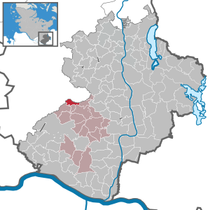
| Location of the municipality of Hamfelde in the Duchy of Lauenburg district | ||
  |
||


Hamfelde is a municipality in the Duchy of Lauenburg in Schleswig-Holstein . Hamfelde has no other districts.
Geography and traffic
The place is on the Bille opposite Hamfelde in the Stormarn district , about 14 km northwest of Schwarzenbek . From 1887 to 1976 Hamfelde was a station on the Schwarzenbek – Bad Oldesloe railway line .
history
The village was mentioned for the first time in 1230 in the Ratzeburg tithe register . From 1612 to 1801 there was a water mill in the center of the parish. Since 1962 the community has belonged to the Schwarzenbek-Land office.
politics
Community representation
Of the nine seats in the municipal council has Wählergemeinschaft WGH since the local elections in 2018 five seats and the voter community AWH four.
coat of arms
Blazon : "In green a lowered slanting silver wave bar, above a golden mill in frontal view, below a golden post horn with silver cords."
Attractions
In Hamfelde there is a gallery Dutch from 1875, which was in operation until 1954. In the following years the mill fell into disrepair until it was renovated as a restaurant in 1976.
leisure
The Hamfelde / Dahmker football club has existed since 1982 . There is also a fishing club that pursues its sport in the local mill pond and a savings club.
Web links
Individual evidence
- ↑ North Statistics Office - Population of the municipalities in Schleswig-Holstein 4th quarter 2019 (XLSX file) (update based on the 2011 census) ( help on this ).
- ↑ Schleswig-Holstein topography. Vol. 4: Groß Sarau - Holstenniendorf . 1st edition Flying-Kiwi-Verl. Junge, Flensburg 2004, ISBN 978-3-926055-75-0 , p. 97 ( dnb.de [accessed on May 1, 2020]).
- ↑ Schleswig-Holstein's municipal coat of arms
Albsfelde | Alt-Mölln | Aumühle | Bäk | Blue | Basedow | Basthorst | Behlendorf | Berkenthin | Besenthal | Bliestorf | Exchanges | Borstorf | Breitenfelde | Bröthen | Brunsmark | Brunstorf | Books | Buchholz | Buchhorst | Dahmker | Dalldorf | Dassendorf | Düchelsdorf | Duvensee | Single house | Elmenhorst | Escheburg | Fitzen | Fredeburg | Fuhlenhagen | Geesthacht | Giesensdorf | Göldenitz | Goddess | Grabau | Grambek | Grinau | Big floor | Great Disnack | Groß Grönau | Great Pampau | Great Sarau | Groß Schenkenberg | Grove | Gudow | Gülzow | Bream | Hamfelde | Hamwarde | Harmsdorf | Havekost | Hohenhorn | Hollenbek | Hornbek | Horst | Juliusburg | Kankelau | Kasseburg | Kastorf | Kittlitz | Klein Pampau | Klein reveler | Plumbing | Klinkrade | Koberg | Kollow | Koethel | Kröppelshagen-Fahrendorf | Krukow | Curved mass | Krüzen | Kuddewörde | Killing | Kulpin | Labenz | Langenlehsten | Lankau | Lance | Lauenburg / Elbe | Clay wheel | Linau | Lüchow | Lütau | Mechow | Möhnsen | Mölln | Mill wheel | Must | Mustin | Niendorf ad St. | Niendorf near Berkenthin | Nuts | Panting | Pogeez | Poggensee | Ratzeburg | Ritzerau | Römnitz | Rondeshagen | Roseburg | Sahms | Salem | Sandesneben | Schiphorst | Schmilau | Schnakenbek | Schoenberg | Schretstaken | Schulendorf | Poking soles | Schwarzenbek | Seedorf | Seven trees | Seven oaks | Sierksrade | Sirksfelde | Steinhorst | Sterley | Stump | Talkau | Tramm | Walksfelde | Wangelau | Wentorf (Amt Sandesneben) | Wentorf near Hamburg | Wiershop | Witzeeze | Wohltorf | Woltersdorf | Worth | Ziethen
Community-free area in the Duchy of Lauenburg
Sachsenwald district