Dassendorf
| coat of arms | Germany map | |
|---|---|---|

|
Coordinates: 53 ° 30 ' N , 10 ° 23' E |
|
| Basic data | ||
| State : | Schleswig-Holstein | |
| Circle : | Duchy of Lauenburg | |
| Office : | High Elbgeest | |
| Height : | 55 m above sea level NHN | |
| Area : | 7.95 km 2 | |
| Residents: | 3405 (Dec. 31, 2019) | |
| Population density : | 428 inhabitants per km 2 | |
| Postal code : | 21521 | |
| Area code : | 04104 | |
| License plate : | RZ | |
| Community key : | 01 0 53 023 | |
| LOCODE : | DE 54C | |
| Office administration address: | Christa-Höppner-Platz 1 21521 Dassendorf |
|
| Website : | ||
| Mayoress : | Martina Falkenberg (WE (We for Dassendorf)) | |
| Location of the community Dassendorf in the Duchy of Lauenburg district | ||
Dassendorf is a municipality in the Duchy of Lauenburg in Schleswig-Holstein . The community is located south of the Sachsenwald, east of Hamburg . It is the administrative seat of the Hohe Elbgeest office .
history
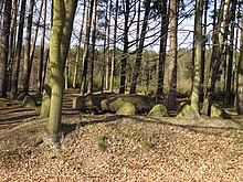
Two "giant beds" ( megalithic tombs ) on the northern edge of the village testify to the early historical settlement of the area around Dassendorf , the street "Am Riesenbett" still indicates this today. These are two more heavily damaged long beds that are registered under the numbers 772 and 773. Grave 772 is approximately 38.0 m long and 6.0 m wide. The hill, which is still 60 cm high, had a rectangular stone setting, which is still incomplete. In the western part the remains of a burial chamber can be seen. The grave 773 further south is about 35.0 m long, 7.0 m wide and 70 cm high. The stone setting of the hill is sketchy. There is a chamber in the eastern third. On the large capstone there are wedge traces of a stone hammer who broke off his attempt to split.
The place was first mentioned in a document in 1334 and was dominated by agriculture for a long time. The old village center in the east shows the typical circular structure of the area .
As early as the 1920s, residents of the neighboring cities, especially Hamburg, began building weekend houses in the so-called "Waldsiedlung" in the west of the municipality. Due to the damage caused by the Allied bombing raids in World War II , numerous bombed-out people moved permanently into their arbours, expanded them and built additional ones. As a result, the forest settlement expanded and is now the focus of the settlement.
It is not least due to the circumstances of the time when the forest settlement came into being that the water supply in the village came from private, mostly in-house wells. Numerous sources made this possible; Evidence can also be found here in some street names (Bornweg, Quellenweg, Schlangenkoppel). A central water supply was not built until the end of the 20th century.
In December 1960, the living and in that village by the name of Karl Neumann at the estate of Prince Otto von Bismarck working Richard Baer , the last commandant of the Auschwitz concentration camp , was arrested.
In 1994 the seat of the Geesthacht-Land office was relocated from Geesthacht to Dassendorf and the office was renamed Hohe Elbgeest .
politics
Community representation
The result of the local elections in May 2018 led to a new distribution of the 17 seats in the Dassendorf municipal council. The voter association "WIR für Dassendorf", founded on July 3, 2017, received 9 seats (52.8%). The SPD (17.4%) and the community of voters GUD "Association of Independent Dassendorfer" (16.8%) each have 3 seats and the CDU has two seats (12.9%).
coat of arms
Blazon : “Split between black and gold. In the front three oak leaves pointing outwards one above the other, in the back an inverted wolf tang in mixed up colors. "
The split in the coat of arms refers to the two districts of Dassendorf. The oak leaves stand for the district that emerged from the forest settlement and the wolf angel for the old village. The Uhrbrock family, who owned the farmer's office in Dassendorf from 1593 to 1876, used this coat of arms as a house and court brand.
traffic
The place is at the intersection between federal highways 207 and 404 .
There is a regular bus service. The HVV bus route 8810 runs between Lübeck-Mölln-Schwarzenbek-Bergedorf.
There is also a bus connection between Aumühle (Krabbenkamp) and Geesthacht. However, this is only used on weekdays. An expansion has taken place, as many commuters from Dassendorf drove to Aumühle by car and then took the S-Bahn to Hamburg from there.
The nearest motorways are the Federal Motorway 25 , which is approx. 7 km away, the Federal Motorway 24 (15 km) and the Federal Motorway 1 (17 km).
Personalities
- Richard Baer (1911–1963), SS-Sturmbannführer and camp commandant of the Auschwitz and Mittelbau-Dora concentration camps , lived in Dassendorf until his arrest on December 20, 1960, where he had hidden for 15 years
- Vera Cordes (* 1961), journalist and television presenter
- Frank Schwalba-Hoth (* 1952), politician (Die Grünen) ( Hessian Landtag , European Parliament ), grew up in Dassendorf
Web links
Individual evidence
- ↑ North Statistics Office - Population of the municipalities in Schleswig-Holstein 4th quarter 2019 (XLSX file) (update based on the 2011 census) ( help on this ).
- ↑ Devin O. Pendas (2006) The Frankfurt Auschwitz Trial, 1963–1965: Genocide, History and the Limits of the Law . Cambridge University Press, p. 48. ISBN 9780521127981
- ^ Geesthacht-Land Office. Archive of the Hohe-Elbgeest Office, July 24, 2006, accessed on September 6, 2018 .
- ↑ Schleswig-Holstein's municipal coat of arms


