
Langenlehsten
| coat of arms | Germany map | |
|---|---|---|

|
Coordinates: 53 ° 30 ' N , 10 ° 44' E |
|
| Basic data | ||
| State : | Schleswig-Holstein | |
| Circle : | Duchy of Lauenburg | |
| Office : | Books | |
| Height : | 26 m above sea level NHN | |
| Area : | 23.37 km 2 | |
| Residents: | 147 (Dec 31, 2019) | |
| Population density : | 6 inhabitants per km 2 | |
| Postal code : | 21514 | |
| Area code : | 04155 | |
| License plate : | RZ | |
| Community key : | 01 0 53 080 | |
| LOCODE : | DE 53T | |
| Office administration address: | Amtsplatz 1 21514 Büchen |
|
| Website : | ||
| Mayor : | Stefan Koring | |
| Location of the municipality of Langenlehsten in the Duchy of Lauenburg district | ||
  |
||

Langenlehsten is a municipality in the Duchy of Lauenburg in Schleswig-Holstein . The community consists of the districts Fortkrug, Bergholz, Neu Bergholz and Waldfrieden. Langenlehsten has a very low population density for a German municipality.
history
Langenlehsten was first mentioned in 1194 as Lesten in the Isfried partition contract . The original name Lesten is of Wendish origin. The village was on the oldest salt road from Lüneburg to Lübeck . Apparently because of the distance to the Gudow Church, a chapel was built in Langenlehsten, which was considered to have been preserved in 1590, but fell into disrepair in 1614. It was handed down from 1683 as no longer available.
The place has been called Langen Lehsten since around 1800. This place name merged with the time to the today's name of the place. An important step towards making Langenlehstens independent was achieved with the completion of the coupling in 1821. The farmers of Langenlehstens have been able to operate independently since 1821. However, the farms only became free property around 1876. During this time, the rural community of Langenlehsten was established, which in 1889 was assigned to the Gudow District, which was founded in that year.
In 1934 the Langenlehsten volunteer fire brigade was founded. Before that there was a fire brigade, to which all male persons between 21 and 56 years belonged. As the penultimate village in the Duchy of Lauenburg, Langenlehsten was provided with electricity in 1927. Electricity did not come to Bergholz until 1954. The first telephone connection was made in 1922. The school building was built in 1869 and extensively modernized in 1956. However, the Langenlehsten school was dissolved at the end of the 1970/71 school year and incorporated into the Büchen school association. With the money raised by selling the school building in 1999, a new village community center was built in 2001.
In 1971 Langenlehsten joined the Gudow-Sterley office (when this office was established) . This was combined from the offices of Gudow and Sterley. After its dissolution, the municipality joined the Büchen office on January 1, 2007 .
Fortkrug was founded in 1704 as a long lease at the ford over the Mühlenbach.
Bergholz was a preliminary work of the Gudow estate, which belonged to the von Bülow family. After the Gudow estate was dissolved in 1928, it was assigned to the Langenlehsten community, which doubled the area of the community.
Neu Bergholz (built 1864–1865) and Waldfrieden (built 1946) are foresters in the Bergholz forestry operation.
coat of arms
Blazon : "Under the pinned golden head of the shield in green an upright two-leafed golden hazelnut branch with three silver nuts."
Attractions
The list of cultural monuments in Langenlehsten includes the cultural monuments entered in the monuments list of Schleswig-Holstein.
photos

Bergholz Forest Estate

Manor house in Fortkrug
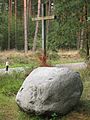
Michael Gartenschläger memorial stone with cross in the municipality of Langenlehsten


Web links
Individual evidence
- ↑ North Statistics Office - Population of the municipalities in Schleswig-Holstein 4th quarter 2019 (XLSX file) (update based on the 2011 census) ( help on this ).
- ↑ Schleswig-Holstein topography. Vol. 6: Kronprinzenkoog - Mühlenrade . 1st edition Flying-Kiwi-Verl. Junge, Flensburg 2006, ISBN 978-3-926055-85-9 , pp. 100 ( dnb.de [accessed June 26, 2020]).
- ↑ Schleswig-Holstein's municipal coat of arms
Albsfelde | Alt-Mölln | Aumühle | Bäk | Blue | Basedow | Basthorst | Behlendorf | Berkenthin | Besenthal | Bliestorf | Exchanges | Borstorf | Breitenfelde | Bröthen | Brunsmark | Brunstorf | Books | Buchholz | Buchhorst | Dahmker | Dalldorf | Dassendorf | Düchelsdorf | Duvensee | Single house | Elmenhorst | Escheburg | Fitzen | Fredeburg | Fuhlenhagen | Geesthacht | Giesensdorf | Göldenitz | Goddess | Grabau | Grambek | Grinau | Big floor | Great Disnack | Groß Grönau | Great Pampau | Great Sarau | Groß Schenkenberg | Grove | Gudow | Gülzow | Bream | Hamfelde | Hamwarde | Harmsdorf | Havekost | Hohenhorn | Hollenbek | Hornbek | Horst | Juliusburg | Kankelau | Kasseburg | Kastorf | Kittlitz | Klein Pampau | Klein reveler | Plumbing | Klinkrade | Koberg | Kollow | Koethel | Kröppelshagen-Fahrendorf | Krukow | Curved mass | Krüzen | Kuddewörde | Killing | Kulpin | Labenz | Langenlehsten | Lankau | Lance | Lauenburg / Elbe | Clay wheel | Linau | Lüchow | Lütau | Mechow | Möhnsen | Mölln | Mill wheel | Must | Mustin | Niendorf ad St. | Niendorf near Berkenthin | Nuts | Panting | Pogeez | Poggensee | Ratzeburg | Ritzerau | Römnitz | Rondeshagen | Roseburg | Sahms | Salem | Sandesneben | Schiphorst | Schmilau | Schnakenbek | Schoenberg | Schretstaken | Schulendorf | Poking soles | Schwarzenbek | Seedorf | Seven trees | Seven oaks | Sierksrade | Sirksfelde | Steinhorst | Sterley | Stump | Talkau | Tramm | Walksfelde | Wangelau | Wentorf (Amt Sandesneben) | Wentorf near Hamburg | Wiershop | Witzeeze | Wohltorf | Woltersdorf | Worth | Ziethen
Community-free area in the Duchy of Lauenburg
Sachsenwald district