
Brunstorf
| coat of arms | Germany map | |
|---|---|---|

|
Coordinates: 53 ° 30 ' N , 10 ° 26' E |
|
| Basic data | ||
| State : | Schleswig-Holstein | |
| Circle : | Duchy of Lauenburg | |
| Office : | Schwarzenbek country | |
| Height : | 47 m above sea level NHN | |
| Area : | 13.76 km 2 | |
| Residents: | 738 (Dec. 31, 2019) | |
| Population density : | 54 inhabitants per km 2 | |
| Postal code : | 21524 | |
| Area code : | 04151 | |
| License plate : | RZ | |
| Community key : | 01 0 53 017 | |
| Office administration address: | Gülzower Strasse 1 21493 Schwarzenbek |
|
| Website : | ||
| Mayor : | Claus Nesemann (AABB) | |
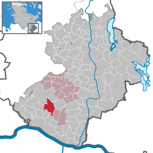
| Location of the municipality of Brunstorf in the Duchy of Lauenburg | ||
  |
||


Brunstorf is a municipality in the Duchy of Lauenburg in Schleswig-Holstein .
geography
Geographical location
The municipality of Brunstorf extends in the area of the Hohe Geest in the east of Hamburg, southeast of the municipality-free area Sachsenwald .
Community structure
In addition to the eponymous main town, the Forsthof and Pulverbau settlements are also located in the municipality.
Neighboring communities
Adjacent municipal areas of Brunstorf are:
| Sachsenwald (municipality-free area) |
||
| Dassendorf |
.svg)
|
Schwarzenbek |
| Hohenhorn | Worth , Hamwarde | Kollow |
geology
The community area deposits glacial sediments from the Saale complex . The soil largely corresponds to a till with grain sizes between silt and sand, which in the municipal area form a terminal moraine up to 57.4 m above sea level. NHN are postponed. The area belongs to the old moraine area in the south of the Duchy of Lauenburg and includes the area north of the high bank on the Elbe east of Hamburg near the Krümmel district of Geesthacht.
The Siekgraben flows through the municipality in an arc from southwest to east . It orbits while the village location west and north and ends shortly thereafter in the western exterior of the city Schwarzenbek in the Black Au , a left tributary of the Bille .
climate
Brunstorf is located in a moderately warm climate zone. There is a significant amount of rainfall throughout the year. Based on the Köppen-Geiger climate classification , Ahrenshöft is assigned to the "Cfb" class. The annual average temperature is 8.4 ° C. The average annual rainfall is 679 mm.
history
The village was first mentioned in a document in 1299.
Since 1948 the community has belonged to the Schwarzenbek office , which in 1962 was merged with the Basthorst office to form the Schwarzenbek-Land office.
politics
Community representation
Of the nine seats in the municipal council, the AABB community of voters has had five seats since the 2008 local elections and the AABDW and ABBW communities of voters have two seats each.
coat of arms
Blazon : “Divided diagonally to the left by red and gold, upright on it in confused colors a lowered ax turned downwards with the front and a raised scythe with the edge turned backwards. A golden leaf above, a red church tower below. "
Attractions
The list of cultural monuments in Brunstorf includes the cultural monuments entered in the list of monuments of Schleswig-Holstein.
Personalities
- Hermann da Fonseca-Wollheim (1851–1938), the German naval officer, most recently Rear Admiral of the Imperial German Navy, was born in Brunstorf
Web links
Individual evidence
- ↑ North Statistics Office - Population of the municipalities in Schleswig-Holstein 4th quarter 2019 (XLSX file) (update based on the 2011 census) ( help on this ).
- ↑ Schleswig-Holstein topography. Vol. 2: Boren - Ellerau . 1st edition Flying-Kiwi-Verl. Junge, Flensburg 2002, ISBN 978-3-926055-68-2 , p. 149 ( dnb.de [accessed June 11, 2020]).
- ↑ Relation: Brunstorf (331249) at OpenStreetMap. Retrieved August 20, 2020 .
- ^ Geological overview map of Schleswig-Holstein. (pdf) Geological Service of the State Office for Agriculture, Environment and Rural Areas, accessed on August 22, 2020 .
- ↑ cf. Digital Atlas North
- ^ Brunstorf climate. Retrieved August 22, 2020 .
- ↑ Schleswig-Holstein's municipal coat of arms
Albsfelde | Alt-Mölln | Aumühle | Bäk | Blue | Basedow | Basthorst | Behlendorf | Berkenthin | Besenthal | Bliestorf | Exchanges | Borstorf | Breitenfelde | Bröthen | Brunsmark | Brunstorf | Books | Buchholz | Buchhorst | Dahmker | Dalldorf | Dassendorf | Düchelsdorf | Duvensee | Single house | Elmenhorst | Escheburg | Fitzen | Fredeburg | Fuhlenhagen | Geesthacht | Giesensdorf | Göldenitz | Goddess | Grabau | Grambek | Grinau | Big floor | Great Disnack | Groß Grönau | Great Pampau | Great Sarau | Groß Schenkenberg | Grove | Gudow | Gülzow | Bream | Hamfelde | Hamwarde | Harmsdorf | Havekost | Hohenhorn | Hollenbek | Hornbek | Horst | Juliusburg | Kankelau | Kasseburg | Kastorf | Kittlitz | Klein Pampau | Klein reveler | Plumbing | Klinkrade | Koberg | Kollow | Koethel | Kröppelshagen-Fahrendorf | Krukow | Curved mass | Krüzen | Kuddewörde | Killing | Kulpin | Labenz | Langenlehsten | Lankau | Lance | Lauenburg / Elbe | Clay wheel | Linau | Lüchow | Lütau | Mechow | Möhnsen | Mölln | Mill wheel | Must | Mustin | Niendorf ad St. | Niendorf near Berkenthin | Nuts | Panting | Pogeez | Poggensee | Ratzeburg | Ritzerau | Römnitz | Rondeshagen | Roseburg | Sahms | Salem | Sandesneben | Schiphorst | Schmilau | Schnakenbek | Schoenberg | Schretstaken | Schulendorf | Poking soles | Schwarzenbek | Seedorf | Seven trees | Seven oaks | Sierksrade | Sirksfelde | Steinhorst | Sterley | Stump | Talkau | Tramm | Walksfelde | Wangelau | Wentorf (Amt Sandesneben) | Wentorf near Hamburg | Wiershop | Witzeeze | Wohltorf | Woltersdorf | Worth | Ziethen
Community-free area in the Duchy of Lauenburg
Sachsenwald district