
Big floor
| coat of arms | Germany map | |
|---|---|---|

|
Coordinates: 53 ° 45 ' N , 10 ° 27' E |
|
| Basic data | ||
| State : | Schleswig-Holstein | |
| Circle : | Duchy of Lauenburg | |
| Office : | Secondary sand nuts | |
| Height : | 43 m above sea level NHN | |
| Area : | 2.7 km 2 | |
| Residents: | 209 (Dec. 31, 2019) | |
| Population density : | 77 inhabitants per km 2 | |
| Postal code : | 23847 | |
| Area code : | 04539 | |
| License plate : | RZ | |
| Community key : | 01 0 53 039 | |
| Office administration address: | Am Amtsgraben 4 23898 Sandesneben |
|
| Website : | ||
| Mayor : | Manfred Fürstenberg | |
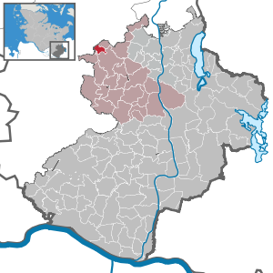
| Location of the community of Groß Boden in the Duchy of Lauenburg | ||
  |
||

Groß Boden is a municipality in the Duchy of Lauenburg district in Schleswig-Holstein, southwest of Lübeck . The community has no other districts.
history
A place on the site of today's Groß Boden was first mentioned in 1310 as Riekenhagen. Under the name Boden , it was created in the area of the desolate village and parish of Schönenborn. The name appears in 1649 after the first farmer bailiff "Boden Tim" (Tim Bubert). Boden belonged to the old sovereign office of Steinhorst . In 1672 Klein Boden came to the lordly office of Rethwisch , while Groß Boden remained with Steinhorst (today the Duchy of Lauenburg), so that from now on two places existed. On December 4, 1813, the battle at Boden between the French and Danes on the one hand and the Alliance on the other hand took place there. Battles also took place here in the German-Danish War of 1864.
coat of arms
Blazon : “Of gold and green, slightly offset to the right sloping head, divided diagonally to the left. On the right, along the split-shield, a floating green sloping beam with five clover leaves, above a red saber, on the left, under a silver frame house, a silver mill wheel, covered by a silver wave beam below. "
traffic
Landstrasse 87 runs through the community of Groß Boden when coming from Rethwisch in the direction of Labenz. In addition, Kreisstraße 58 begins in Groß Boden. There are two bus stops in Groß Boden that are served Monday to Saturday. The federal highway 1 is only about five minutes away from Groß Boden.
Web links
Individual evidence
- ↑ North Statistics Office - Population of the municipalities in Schleswig-Holstein 4th quarter 2019 (XLSX file) (update based on the 2011 census) ( help on this ).
- ↑ Schleswig-Holstein topography. Vol. 3: Ellerbek - Groß Rönnau . 1st edition Flying-Kiwi-Verl. Junge, Flensburg 2003, ISBN 978-3-926055-73-6 , p. 325 ( dnb.de [accessed April 26, 2020]).
- ^ Hans von Ahlefeld, Max Gottschalck: History of the 1st Thuringian Infantry Regiment No. 31; together with a list of all officers, doctors and paymasters who have served in it. Berlin 1894.
- ↑ Schleswig-Holstein's municipal coat of arms
Albsfelde | Alt-Mölln | Aumühle | Bäk | Blue | Basedow | Basthorst | Behlendorf | Berkenthin | Besenthal | Bliestorf | Exchanges | Borstorf | Breitenfelde | Bröthen | Brunsmark | Brunstorf | Books | Buchholz | Buchhorst | Dahmker | Dalldorf | Dassendorf | Düchelsdorf | Duvensee | Single house | Elmenhorst | Escheburg | Fitzen | Fredeburg | Fuhlenhagen | Geesthacht | Giesensdorf | Göldenitz | Goddess | Grabau | Grambek | Grinau | Big floor | Great Disnack | Groß Grönau | Great Pampau | Great Sarau | Groß Schenkenberg | Grove | Gudow | Gülzow | Bream | Hamfelde | Hamwarde | Harmsdorf | Havekost | Hohenhorn | Hollenbek | Hornbek | Horst | Juliusburg | Kankelau | Kasseburg | Kastorf | Kittlitz | Klein Pampau | Klein reveler | Plumbing | Klinkrade | Koberg | Kollow | Koethel | Kröppelshagen-Fahrendorf | Krukow | Curved mass | Krüzen | Kuddewörde | Killing | Kulpin | Labenz | Langenlehsten | Lankau | Lance | Lauenburg / Elbe | Clay wheel | Linau | Lüchow | Lütau | Mechow | Möhnsen | Mölln | Mill wheel | Must | Mustin | Niendorf ad St. | Niendorf near Berkenthin | Nuts | Panting | Pogeez | Poggensee | Ratzeburg | Ritzerau | Römnitz | Rondeshagen | Roseburg | Sahms | Salem | Sandesneben | Schiphorst | Schmilau | Schnakenbek | Schoenberg | Schretstaken | Schulendorf | Poking soles | Schwarzenbek | Seedorf | Seven trees | Seven oaks | Sierksrade | Sirksfelde | Steinhorst | Sterley | Stump | Talkau | Tramm | Walksfelde | Wangelau | Wentorf (Amt Sandesneben) | Wentorf near Hamburg | Wiershop | Witzeeze | Wohltorf | Woltersdorf | Worth | Ziethen
Community-free area in the Duchy of Lauenburg
Sachsenwald district