
Schnakenbek
| coat of arms | Germany map | |
|---|---|---|

|
Coordinates: 53 ° 23 ' N , 10 ° 30' E |
|
| Basic data | ||
| State : | Schleswig-Holstein | |
| Circle : | Duchy of Lauenburg | |
| Office : | Luetau | |
| Height : | 27 m above sea level NHN | |
| Area : | 13.02 km 2 | |
| Residents: | 874 (Dec. 31, 2019) | |
| Population density : | 67 inhabitants per km 2 | |
| Postal code : | 21481 | |
| Area code : | 04153 | |
| License plate : | RZ | |
| Community key : | 01 0 53 111 | |
| LOCODE : | DE 55K | |
| Office administration address: | Amtsplatz 6 21481 Lauenburg / Elbe |
|
| Website : | ||
| Mayor : | Christian Pehmöller | |
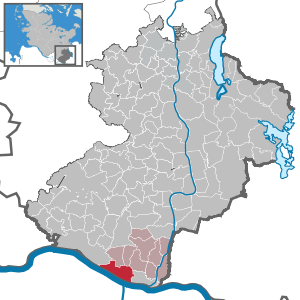
| Location of the community Schnakenbek in the Duchy of Lauenburg district | ||
  |
||

Schnakenbek is a municipality in the Duchy of Lauenburg in Schleswig-Holstein .
geography
The community is separated from the Elbe by an approximately 300 m wide strip of forest. The place is cut from west to east by the federal highway 5 and is thus directly connected to the city of Hamburg .
history
Beginnings
The first documented mention of Schnakenbek was in 1230 in the Ratzeburg tithe register as Snakenbeke . The place name goes back to Wolfgang Laur on a Low German water body name with the meaning "Schlangenbach". The place was at a ford of the old salt road from Lüneburg to Lübeck , for the protection of which the Ertheneburg was built, which Heinrich the Lion had burned down in 1181.
At the end of the Second World War
As a result of the Second World War , the population of the community rose sharply around 1945 due to numerous refugees and bombed-out Hamburgers. Germany lost the war in 1945 and it was gradually occupied. In the last days of the war, the Allied troops moved further and further north. Preparations for the expected fighting began in April in the Duchy of Lauenburg. Positions, foxholes, trenches and anti-tank traps equipped with mines were established. In addition, various bridges were prepared for blasting.
In the early morning of April 29, 1945, the British troops crossed from Artlenburg to the opposite bank of the Elbe at Glüsinger Grund and thus to the community of Schnakenbek with armored ferries and floating tanks . They set up a bridgehead on Glüsinger Grund . Lauenburg was taken in the morning. Pontoon bridges were erected by evening and the British troops continued to advance to Krüzen , Lütau and Basedow . On May 1st, Geesthacht and Büchen were occupied . Lübeck could already be occupied on May 2nd . On the same day, the executive government of the Reich fled from the Eutin - Plön area, 80 kilometers further north, from the approaching British troops to Flensburg - Mürwik . Only two days later the surrender of all German troops in northwest Germany, the Netherlands and Denmark took place .
Since the post-war period
The Elbe ferry Schnakenbek-Artlenburg ceased operations in 1964.
With a view to the historical events of 1945, the Elbe crossing and its consequences, in 1977, 1997 and 2017 the German 130th Panzer Pioneer Battalion and the British 28th Amphibious Engineer Regiment affirmed their partnership, which had been agreed in the 1970s, through an exercise in which they were temporarily set up an amphibious bridge at Artlenburg across the Elbe to Schnakenbek.
coat of arms
Blazon : “Divided by gold and blue. Above a growing red lion, below a golden ferry boat with a wavy waterline. "
Attractions
The list of cultural monuments in Schnakenbek includes the cultural monuments entered in the list of monuments of Schleswig-Holstein.
- Chapel from 1855
- Ruins of the Ertheneburg .
societies
In the community there is the Schnakenbek game and sports association from 1965 , which offers many sports and leisure opportunities. Among other things, there is football for all ages and genders as well as table tennis.
Schnakenbek is also jokingly referred to as the “carnival stronghold”. Every year there is a big carnival parade by the Schnakenbeker Carnevalsverein . The highlight is the proclamation of the prince couple who are driven through the village in a carriage during the parade. The well-known ceremonial meetings are also worth mentioning.
A half-day kindergarten to look after children aged three to six is available on site.
Web links
Individual evidence
- ↑ North Statistics Office - Population of the municipalities in Schleswig-Holstein 4th quarter 2019 (XLSX file) (update based on the 2011 census) ( help on this ).
- ↑ Wolfgang Laur : Historisches Ortname Lexikon von Schleswig-Holstein , 2nd edition, p. 580.
- ^ Lübecker Nachrichten : Last fighting in spring 1945 , from: April 14, 2015; accessed on: May 30, 2018
- ^ Lübecker Nachrichten : Last fighting in spring 1945 , from: April 14, 2015; accessed on: May 30, 2018
- ↑ Kröppelshagen-Fahrendorf village newspaper. End of the war 70 years ago , p. 10, from: Spring 2015; accessed on: May 30, 2018
- ^ Lübecker Nachrichten : Last fighting in spring 1945 , from: April 14, 2015; accessed on: May 30, 2018
- ^ Bergedorfer Zeitung : Series: 65 years ago. When the war came to Lauenburg on: April 28, 2010
- ↑ Kröppelshagen-Fahrendorf village newspaper. End of the war 70 years ago , p. 10, from: Spring 2015; accessed on: May 30, 2018
- ↑ British Army and Bundeswehr build a floating bridge over the Elbe , from: December 5, 2017; accessed on: May 30, 2018
- ↑ Schleswig-Holsteinischer Zeitungsverlag : Elbquerung in Schnakenbek: Military Spectacle: German and British soldiers build amphibious bridge , from: November 30, 2017 and Lübecker Nachrichten : Military Spectacle: Bridge over the Elbe , from: December 1, 2017; Accessed on: May 30, 2018
- ↑ Schleswig-Holstein's municipal coat of arms
Albsfelde | Alt-Mölln | Aumühle | Bäk | Blue | Basedow | Basthorst | Behlendorf | Berkenthin | Besenthal | Bliestorf | Exchanges | Borstorf | Breitenfelde | Bröthen | Brunsmark | Brunstorf | Books | Buchholz | Buchhorst | Dahmker | Dalldorf | Dassendorf | Düchelsdorf | Duvensee | Single house | Elmenhorst | Escheburg | Fitzen | Fredeburg | Fuhlenhagen | Geesthacht | Giesensdorf | Göldenitz | Goddess | Grabau | Grambek | Grinau | Big floor | Great Disnack | Groß Grönau | Great Pampau | Great Sarau | Groß Schenkenberg | Grove | Gudow | Gülzow | Bream | Hamfelde | Hamwarde | Harmsdorf | Havekost | Hohenhorn | Hollenbek | Hornbek | Horst | Juliusburg | Kankelau | Kasseburg | Kastorf | Kittlitz | Klein Pampau | Klein reveler | Plumbing | Klinkrade | Koberg | Kollow | Koethel | Kröppelshagen-Fahrendorf | Krukow | Curved mass | Krüzen | Kuddewörde | Killing | Kulpin | Labenz | Langenlehsten | Lankau | Lance | Lauenburg / Elbe | Clay wheel | Linau | Lüchow | Lütau | Mechow | Möhnsen | Mölln | Mill wheel | Must | Mustin | Niendorf ad St. | Niendorf near Berkenthin | Nuts | Panting | Pogeez | Poggensee | Ratzeburg | Ritzerau | Römnitz | Rondeshagen | Roseburg | Sahms | Salem | Sandesneben | Schiphorst | Schmilau | Schnakenbek | Schoenberg | Schretstaken | Schulendorf | Poking soles | Schwarzenbek | Seedorf | Seven trees | Seven oaks | Sierksrade | Sirksfelde | Steinhorst | Sterley | Stump | Talkau | Tramm | Walksfelde | Wangelau | Wentorf (Amt Sandesneben) | Wentorf near Hamburg | Wiershop | Witzeeze | Wohltorf | Woltersdorf | Worth | Ziethen
Community-free area in the Duchy of Lauenburg
Sachsenwald district