
Schulendorf
| coat of arms | Germany map | |
|---|---|---|

|
Coordinates: 53 ° 28 ' N , 10 ° 34' E |
|
| Basic data | ||
| State : | Schleswig-Holstein | |
| Circle : | Duchy of Lauenburg | |
| Office : | Books | |
| Height : | 31 m above sea level NHN | |
| Area : | 11.39 km 2 | |
| Residents: | 448 (Dec. 31, 2019) | |
| Population density : | 39 inhabitants per km 2 | |
| Postcodes : | 21516, 21514 | |
| Primaries : | 04151, 04155 | |
| License plate : | RZ | |
| Community key : | 01 0 53 115 | |
| LOCODE : | DE 53W | |
| Office administration address: | Amtsplatz 1 21514 Büchen |
|
| Website : | ||
| Mayor : | Jürgen Borchers (FWG) | |
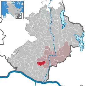
| Location of the community Schulendorf in the Duchy of Lauenburg | ||
  |
||

Schulendorf is a municipality in the Duchy of Lauenburg in Schleswig-Holstein . The community consists of the localities Bartelsdorf, Franzhagen and Schulendorf.
history
Schulendorf and Bartelsdorf were first mentioned in 1230 in the Ratzeburg tithe register, each with five hooves . They were called "Sculenthorp" and "Bertoldestorp" and are probably German names. “Schools” means something like “to hide”. "Bartels" is a nickname that means "shiny, governing (ruling)". Both villages were probably created at the end of the 12th century during the German colonization of eastern Elbe. Archaeological finds indicate an older, Slavic settlement layer. Schulendorf and Bartelsdorf were farming settlements. They paid their tithe to an unspecified nobleman Reinfried, who also owned Krüzen and Hasenthal.
Franzhagen is a younger settlement. It was first mentioned in 1605. The then ruling Duke Franz II had a manor house built in the Franzhof with an accompanying court chapel. Local history research assumes that it was built on the spot that is named "Lelecowe" in the tithe register. A legend has been passed down about this manor house.
In the 17th century, Duke Franz resided in Franzhof, who, like all princes of his time, wanted to rule according to the real French model. He had a large castle built and beautiful gardens set up around it. Like many other princes, he lacked the necessary money. But that didn't bother him. He once planned to surround his courtyard with a wall and a moat. In addition, he lacked water nearby. Because the bubble bush was now high up and rich in water, a collecting basin, named Baarsteich after a later owner, was built there and a deep ditch, still called the Hofgraben, was dug after the castle. A few meters it touched the Franzhagener Feldmark, then money and water ran out. The workers were finally rewarded with leather money. In revenge for this shameful deception, people are still talking about the "leather duke".
There was also a chapel in the courtyard, which Duchess Marie had built in 1608. The entire facility was demolished in 1716. During its demolition, the art treasures of the chapel were mainly brought to the Marienkirche in Büchen. Today the name Franzhof is a reminder of the ducal past of Schulendorf.
Schulendorf was linked in 1792 and Bartelsdorf in 1803. Until the Prussian administrative reforms at the end of the 19th century, Bartelsdorf, Franzhagen and Schulendorf belonged to the lordly office of Lauenburg. In 1889 they came to the new district of Pötrau.
In 1900 there were 331 inhabitants in the three villages: 122 in Bartelsdorf, 106 in Franzhagen and 103 in Schulendorf. These were merged into one political municipality in 1938 as part of the Greater Hamburg Act of 1937.
politics
Community representation
In the local elections in 2013, the newly founded voting community ABS, Active Citizens Schulendorf won two of the nine seats in the local council. The remaining seven seats were won by the FWG constituency, which was previously represented alone.
coat of arms
Blazon : "Three red houses 1: 2 in gold, divided by a blue corrugated goblet with a black mill wheel at the intersection."
The houses of the coat of arms awarded in 2002 symbolize the three districts of Bartelsdorf, Franzhagen and Schulendorf. For historical reasons there is also a black mill wheel in the coat of arms, which stands for the New Mill, which was built in 1690 as a replacement for the murder mill that was destroyed in the Thirty Years War .
economy
traffic
Each of the three districts has a connection to the public transport network of the HVV . The nearest motorway junction ( Bundesautobahn 24 Hamburg-Berlin) is eight kilometers away. There is also a connection to the federal road 209 towards Lauenburg / Schwarzenbek.
Companies
Various small companies are located in the Schulendorf community. The Marienhof riding stables are also located in the Franzhagen district. The district of Bartelsdorf also has two farm shops where you can buy rural specialties.
Web links
Individual evidence
- ↑ North Statistics Office - Population of the municipalities in Schleswig-Holstein 4th quarter 2019 (XLSX file) (update based on the 2011 census) ( help on this ).
- ↑ Schleswig-Holstein topography. Vol. 9: Schönberg - Tielenhemme . 1st edition Flying-Kiwi-Verl. Junge, Flensburg 2007, ISBN 978-3-926055-91-0 , p. 27 ( dnb.de [accessed July 30, 2020]).
- ^ Wolfgang Prange: Settlement history of the state of Lauenburg in the Middle Ages. Neumünster 1960, page 143
- ^ History of Schulendorf
- ↑ Schleswig-Holstein's municipal coat of arms
- ↑ http://www.gestuet-marienhof.de/
Albsfelde | Alt-Mölln | Aumühle | Bäk | Blue | Basedow | Basthorst | Behlendorf | Berkenthin | Besenthal | Bliestorf | Exchanges | Borstorf | Breitenfelde | Bröthen | Brunsmark | Brunstorf | Books | Buchholz | Buchhorst | Dahmker | Dalldorf | Dassendorf | Düchelsdorf | Duvensee | Single house | Elmenhorst | Escheburg | Fitzen | Fredeburg | Fuhlenhagen | Geesthacht | Giesensdorf | Göldenitz | Goddess | Grabau | Grambek | Grinau | Big floor | Great Disnack | Groß Grönau | Great Pampau | Great Sarau | Groß Schenkenberg | Grove | Gudow | Gülzow | Bream | Hamfelde | Hamwarde | Harmsdorf | Havekost | Hohenhorn | Hollenbek | Hornbek | Horst | Juliusburg | Kankelau | Kasseburg | Kastorf | Kittlitz | Klein Pampau | Klein reveler | Plumbing | Klinkrade | Koberg | Kollow | Koethel | Kröppelshagen-Fahrendorf | Krukow | Curved mass | Krüzen | Kuddewörde | Killing | Kulpin | Labenz | Langenlehsten | Lankau | Lance | Lauenburg / Elbe | Clay wheel | Linau | Lüchow | Lütau | Mechow | Möhnsen | Mölln | Mill wheel | Must | Mustin | Niendorf ad St. | Niendorf near Berkenthin | Nuts | Panting | Pogeez | Poggensee | Ratzeburg | Ritzerau | Römnitz | Rondeshagen | Roseburg | Sahms | Salem | Sandesneben | Schiphorst | Schmilau | Schnakenbek | Schoenberg | Schretstaken | Schulendorf | Poking soles | Schwarzenbek | Seedorf | Seven trees | Seven oaks | Sierksrade | Sirksfelde | Steinhorst | Sterley | Stump | Talkau | Tramm | Walksfelde | Wangelau | Wentorf (Amt Sandesneben) | Wentorf near Hamburg | Wiershop | Witzeeze | Wohltorf | Woltersdorf | Worth | Ziethen
Community-free area in the Duchy of Lauenburg
Sachsenwald district