Escheburg
| coat of arms | Germany map | |
|---|---|---|

|
Coordinates: 53 ° 28 ' N , 10 ° 19' E |
|
| Basic data | ||
| State : | Schleswig-Holstein | |
| Circle : | Duchy of Lauenburg | |
| Office : | High Elbgeest | |
| Height : | 50 m above sea level NHN | |
| Area : | 8.91 km 2 | |
| Residents: | 3461 (Dec. 31, 2019) | |
| Population density : | 388 inhabitants per km 2 | |
| Postal code : | 21039 | |
| Primaries : | 040, 04152 | |
| License plate : | RZ | |
| Community key : | 01 0 53 028 | |
| LOCODE : | DE HEB | |
| Office administration address: | Christa-Höppner-Platz 1 21521 Dassendorf |
|
| Website : | ||
| Mayor : | Rainer Bork (EEC) | |
| Location of the municipality of Escheburg in the Duchy of Lauenburg district | ||
Escheburg is a municipality in the Duchy of Lauenburg in Schleswig-Holstein . Vossmoor is located in the municipality.
geography
Geographical location
The municipality of Escheburg borders directly on Hamburg's southeastern border. The village itself is about three kilometers east of the state border and about four kilometers west of Geesthacht . Escheburg is thus located directly in the so-called Speckgürtel Hamburg , in the scenic area between the Sachsenwald in the north and the Elbe in the south. The extension of the place in all four directions is consistently less than two kilometers and thus makes it manageable.
geology
The place Escheburg is located directly on the wooded Geest slope. In prehistory, the steep slope represented the northern bank of the Elbe glacial valley . It was formed towards the end of the last ice age, the Vistula Ice Age, about 14,500 years ago, when the glaciers that had remained in the area of today's north and north-east Germany melted and the meltwater masses flowed over the Elbe glacial valley into the lower North Sea . In this respect, the geology of the region has remained unchanged over the millennia and extends from Hamburg-Bergedorf via Börnsen and Escheburg to Geesthacht.
The place Escheburg is essentially on the Geest , i.e. the upper, drier part, and extends seamlessly over the slope into the wetter marsh . The special thing about the geology of the place is, among other things, the height difference of around 50 meters within the village, which is considerable for this region due to the steep slope. This creates several roads with steep inclines or steep gradients (up to nine percent). The high location allows a wide view over the Vier- und Marschlande of the Hamburg district Hamburg-Bergedorf to the Harburg mountains in the north of Lower Saxony.
The Dalbek brook separates the municipality of Escheburg from its neighboring municipality of Börnsen. The forested nature reserve Dalbekschlucht lies between the villages , which borders directly on Escheburg to the west and which, like the forested Bistal in the east, has a major impact on its geology .
Local breakdown and residential structure
The village of Escheburg consists of the actual village and the much smaller district of Vossmoor. The district of Vossmoor is about three kilometers south of the actual town, surrounded by forests, directly adjacent to the Hamburg district of Altengamme ; a number of houses on Knollgraben can only be reached via Hamburg. The district of Vossmoor is only a few hundred meters away from the Elbe and the high Elbe dike.
Escheburg consists mostly of single-family houses (single, double and row houses). There are also isolated two-story houses with condominiums and rental apartments along the Stubbenberg .
The building fabric comes from several times. In addition to older farmhouses, there are also some villa-like houses from the Wilhelminian era . However, the main stock consists of new buildings (after 1945 until today).
In addition to the existing buildings, Escheburg also has smaller, contemplative new development areas, which mainly families from the surrounding area, and here in particular from Hamburg, moved and which have a major impact on the image today. This not only enriched the town with attractive residential areas, but also gave the community a higher number of high-income net payers from the 1990s and thus had a direct impact on the community coffers.
In 1990 the new development area Rehmenkoppel was built in the northern center of the village, followed in 1994 by Am Grüppental in the western part. In 2001 the new building area Am Soll was built and Hohenstein followed in 2004 , both marking the northern end of the town. In 2005 the small new construction area Ahornweg was built in the heart of Escheburg. The new buildings consist of modern single, double and terraced houses.
history
The place Escheburg originated during the German settlement period and was first mentioned in 1319. Escheburg was assigned to the parish of Bergedorf, even after the Reinbek monastery took over the manor in 1370. After the dissolution of the monastery in the course of the Reformation , Escheburg belonged to the ducal office in Schwarzenbek .
In 1598 the church conditions were reorganized and Hohenhorn was the new church location. Like many villages in Lauenburg, Escheburg suffered from the consequences of the Thirty Years' War , as it is located on an important road ( e.g. along the former B 5 ) that led to the former Elbfurts.
From 1650 to 1838 Escheburg was an important post station on the route from Lauenburg to Hamburg. After the last Duke of Sachsen-Lauenburg died in 1689, the place Escheburg also fell to Braunschweig - Lüneburg . In 1705 the land was inherited by the Elector of Hanover . The "Hanoverian" era began, the so-called Welfenbrücke from 1777 in the Vossmoor district bears witness to it. A new administration was introduced and the many parcels “linked” to form larger units. This is how the appearance of today's field corridor with the Knicks and Reddern came about .
During the French occupation at the beginning of the 19th century, Escheburg was Mairie for the surrounding villages. After the Congress of Vienna in 1815, Denmark became the new sovereign, then Prussia in 1866 , only to be incorporated into the province of Schleswig-Holstein in 1876 as the place of the Duchy of Lauenburg . After the Bergedorf-Geesthacht Railway was founded , Escheburg received a train station in 1906. This formed the core for new residential buildings along the Alte Landstrasse, which were largely built by craftsmen and workers. Income from the May flower cultivation helped many with the financing.
During the Second World War , many bombed-out Hamburgers and refugees from the east had to be taken in. The population doubled by leaps and bounds from 560 in 1939 to 968 in 1946. New housing estates were built.
Since the 1960s, many Hamburg residents have also moved to Escheburg. Agriculture shaped the community for centuries . Today, the place impressed particularly the proximity to Hamburg and agriculture no longer plays a role.
Population development
In the period from 1939 to 2003 the population had increased more than fivefold. This continuous increase in population has continued in the recent past. Because the number of immigrants significantly exceeded the number of departures. The population continued to rise, from 2884 to 3254 between 2003 and 2007 alone. On December 31, 2014, Escheburg had 3345 inhabitants.
politics
Community representation
Since the local elections in May 2018, the EEC (Escheburg Voting Association) has five, Bündnis90 / Die Grünen four, CDU four and the SPD four seats. Mayor is Rainer Bork from the EEC, who was elected with the votes of Bündnis90 / Die Grünen.
coat of arms
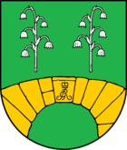
Blazon : "In green under two silver May flower stems, a golden bridge consisting of hewn cuboids, the keystone of which bears the intertwined letters G and R under a princely crown."
The two flowers refer to the may flower culture that has been practiced in the Escheburg district since the previous century. For the municipality part of Vossmoor, the bridge built there in 1777 is shown in the coat of arms.
Culture and sights
The list of cultural monuments in Escheburg includes the cultural monuments entered in the list of monuments of Schleswig-Holstein.
Natural monument
In the west of the municipality of Escheburg lies the 66 hectare nature reserve Dalbekschlucht . The nature reserve is a forested creek canyon system cut deep into the steep slopes, which is crossed by the Dalbek creek and which was formed around 18,000 to 14,500 years ago. At this time the glaciers in the Holstein area came to a standstill and their melted water dug their way to the Elbe glacial valley deep into the earth. The deep erosion made it possible to gain insights into the geological age of the Tertiary , which was at least 65 million years ago .
In the east of the municipality of Escheburg lies the equally wooded and similarly large Bistal .
Archaeological monument
In the northeastern part of the municipality of Escheburg there are 33 plowed prehistoric burial mounds . They probably come from the early Bronze Age and in some cases have a diameter of up to about 30 meters. They only have a low height. The area is now used as a golf course.
The burial mounds were created by first laying tree or plank coffins on the surface of the site, which were then mostly covered with pebbles the size of a head. Then these were covered with a mound of earth. A stone circle around the burial mound provided the outer support. In the late Bronze Age, in the subsequent Iron Age and into the Migration Period , the ashes of the deceased were collected in urns. In the region around Escheburg, the urns were buried in the mound of already existing burial mounds.
Economy and Infrastructure
The infrastructure of Escheburg is weak. Except for a bakery, there are no other shops. The nearest large supermarkets, shopping centers and pedestrian shopping areas are in Wentorf near Hamburg , Hamburg-Bergedorf and Geesthacht. However, there are three restaurants, one in the old train station, another on the golf course and the latter on the B5. Likewise, no doctors have settled in Escheburg. The nearest hospitals are in Hamburg, Reinbek and Geesthacht.
The place has a primary school (reliable all-day school) and two kindergartens ; In addition, there is a sports club with an artificial turf pitch built in 2016, the Escheburg volunteer fire department , a golf course and a church .
Escheburg is connected to the Hamburger Verkehrsverbund and is frequented by the bus with the identification number 8890. The former federal highway 5 crosses Escheburg and leads in the east to Geesthacht and in the west through Hamburg-Bergedorf on to Hamburg. The nearby federal highway 404 leads in the north to Kiel and in the south to Lüneburg. The Geesthacht motorway junction is three kilometers away, and the Hamburg-Curslack junction is six kilometers away. The federal highway 25 (marsh line) leads to the federal highway 1 to Lübeck and Bremen and via the federal highway 255 directly to the center of Hamburg.
The railway line from Hamburg-Bergedorf to Geesthacht is only used for occasional freight transport and by the museum railway of the Geesthacht Railway Working Group .
Web links
Individual evidence
- ↑ North Statistics Office - Population of the municipalities in Schleswig-Holstein 4th quarter 2019 (XLSX file) (update based on the 2011 census) ( help on this ).
- ↑ Schleswig-Holstein topography. Vol. 3: Ellerbek - Groß Rönnau . 1st edition Flying-Kiwi-Verl. Junge, Flensburg 2003, ISBN 978-3-926055-73-6 , p. 62 ( dnb.de [accessed on April 21, 2020]).
- ↑ Schleswig-Holstein's municipal coat of arms


