
Great Sarau
| coat of arms | Germany map | |
|---|---|---|

|
Coordinates: 53 ° 46 ' N , 10 ° 44' E |
|
| Basic data | ||
| State : | Schleswig-Holstein | |
| Circle : | Duchy of Lauenburg | |
| Office : | Lauenburg lakes | |
| Height : | 16 m above sea level NHN | |
| Area : | 17.08 km 2 | |
| Residents: | 1013 (Dec. 31, 2019) | |
| Population density : | 59 inhabitants per km 2 | |
| Postal code : | 23627 | |
| Primaries : | 04509, 04541 | |
| License plate : | RZ | |
| Community key : | 01 0 53 043 | |
| Office administration address: | Fünfhausen 1 23909 Ratzeburg |
|
| Website : | ||
| Mayor : | Hartmut Schwarz (ABG) | |
| Location of the community of Groß Sarau in the Duchy of Lauenburg | ||
  |
||

Groß Sarau is a municipality in the Duchy of Lauenburg in Schleswig-Holstein .
geography
Groß Sarau is located on the west bank of the Ratzeburg Lake in the Lauenburg Lakes Nature Park . In addition to Groß Sarau itself, districts include Gut Tüschenbek (formerly part of the independent Tüschenbek office), Nädlershorst , Ziegelhorst, Rothenhusen , Hornstorf, Klein Sarau and Holstendorf. The southern half of the Blankensee belongs to the municipality.
history
It was first mentioned in a document in 1230. The place name comes from Old Polish and means “place at the slash and burn”. On December 1, 1971, the former communities of Klein Sarau and Holstendorf were incorporated.
politics
Community representation
Since the local elections in 2008 , the ABG voter community has all eleven seats of the local council.
coat of arms
Blazon : “Divided by green and blue by a silver wave bar, slightly lowered. Above a golden thatched roof house and a silver horseshoe with upturned cleats, below a golden boat with two oars. "
Attractions
The list of cultural monuments in Groß Sarau includes the cultural monuments entered in the monuments list of Schleswig-Holstein.
traffic
The former federal highway 207 Alte Salzstrasse still runs through the town and crosses the federal highway 20 (junction Groß Sarau) at the northern municipal boundary . At Rothenhusen the only bridge between Lübeck and Ratzeburg led over the Wakenitz to Mecklenburg-Western Pomerania . It was demolished in 2008 and replaced by a new building in 2009.
At the end of 2006, considerations were voiced for the first time to rebuild the further bridge over the Wakenitz near Nädlershorst to better develop the hiking trails between the Mecklenburg neighboring community of Lüdersdorf with the northern edge of the Schaalsee biosphere reserve and the Lauenburg Lakes Nature Park . This had existed from the 1930s until the establishment of the inner-German border and was finally demolished in 1975. However, it was still recognizable with the former ramps and bridge bearings and was still accessible from the original network of paths. The bridge was built with funds from the Hamburg Metropolitan Region . The sculpture Overcoming Borders on the west side of the Wakenitz is a work by the sculptor Claus Görtz, who is based in Schattin on the east side . It was created using the barriers that were there until 2008 and secured the orphaned ramps of the previous bridge. From Lübeck to Rothenhusen, the Drägerweg runs as a hiking trail along the meadow landscape of the Wakenitz lowland.
leisure
The weekend settlement Schanzenberg is the sailing center on Ratzeburg Lake. The Schanzenberg sailing center houses the summer bases of the three Lübeck sailing clubs , the Lübeck Sailing Club , the Sailing Club Hansa and the Sailing Club Wakenitz . The bathing area of the community on the Großer Ratzeburger See is monitored by the DLRG in the summer months .
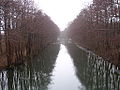
photos

View from the bridge at Nädlershorst to the Wakenitz

Construction of a new bridge between Groß Sarau and Schattin near Nädlershorst in 2008
View from Nädlershorst southwards to the Lange Jammer der Wakenitz

Former bridge from the "post-reunification period" near Rothenhusen, now demolished

Tüschenbek estate in the 16th century (reconstruction)
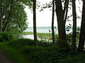
Ratzeburg Lake


Web links
Individual evidence
- ↑ North Statistics Office - Population of the municipalities in Schleswig-Holstein 4th quarter 2019 (XLSX file) (update based on the 2011 census) ( help on this ).
- ↑ a b Schleswig-Holstein topography. Vol. 4: Groß Sarau - Holstenniendorf . 1st edition Flying-Kiwi-Verl. Junge, Flensburg 2004, ISBN 978-3-926055-75-0 , p. 1 ( dnb.de [accessed April 30, 2020]).
- ^ Federal Statistical Office (ed.): Historical municipality directory for the Federal Republic of Germany. Name, border and key number changes in municipalities, counties and administrative districts from May 27, 1970 to December 31, 1982 . W. Kohlhammer GmbH, Stuttgart / Mainz 1983, ISBN 3-17-003263-1 , p. 182 .
- ↑ Schleswig-Holstein's municipal coat of arms
Albsfelde | Alt-Mölln | Aumühle | Bäk | Blue | Basedow | Basthorst | Behlendorf | Berkenthin | Besenthal | Bliestorf | Exchanges | Borstorf | Breitenfelde | Bröthen | Brunsmark | Brunstorf | Books | Buchholz | Buchhorst | Dahmker | Dalldorf | Dassendorf | Düchelsdorf | Duvensee | Single house | Elmenhorst | Escheburg | Fitzen | Fredeburg | Fuhlenhagen | Geesthacht | Giesensdorf | Göldenitz | Goddess | Grabau | Grambek | Grinau | Big floor | Great Disnack | Groß Grönau | Great Pampau | Great Sarau | Groß Schenkenberg | Grove | Gudow | Gülzow | Bream | Hamfelde | Hamwarde | Harmsdorf | Havekost | Hohenhorn | Hollenbek | Hornbek | Horst | Juliusburg | Kankelau | Kasseburg | Kastorf | Kittlitz | Klein Pampau | Klein reveler | Plumbing | Klinkrade | Koberg | Kollow | Koethel | Kröppelshagen-Fahrendorf | Krukow | Curved mass | Krüzen | Kuddewörde | Killing | Kulpin | Labenz | Langenlehsten | Lankau | Lance | Lauenburg / Elbe | Clay wheel | Linau | Lüchow | Lütau | Mechow | Möhnsen | Mölln | Mill wheel | Must | Mustin | Niendorf ad St. | Niendorf near Berkenthin | Nuts | Panting | Pogeez | Poggensee | Ratzeburg | Ritzerau | Römnitz | Rondeshagen | Roseburg | Sahms | Salem | Sandesneben | Schiphorst | Schmilau | Schnakenbek | Schoenberg | Schretstaken | Schulendorf | Poking soles | Schwarzenbek | Seedorf | Seven trees | Seven oaks | Sierksrade | Sirksfelde | Steinhorst | Sterley | Stump | Talkau | Tramm | Walksfelde | Wangelau | Wentorf (Amt Sandesneben) | Wentorf near Hamburg | Wiershop | Witzeeze | Wohltorf | Woltersdorf | Worth | Ziethen
Community-free area in the Duchy of Lauenburg
Sachsenwald district