
Luetau
| coat of arms | Germany map | |
|---|---|---|

|
Coordinates: 53 ° 26 ' N , 10 ° 33' E |
|
| Basic data | ||
| State : | Schleswig-Holstein | |
| Circle : | Duchy of Lauenburg | |
| Office : | Luetau | |
| Height : | 31 m above sea level NHN | |
| Area : | 11.24 km 2 | |
| Residents: | 710 (Dec. 31, 2019) | |
| Population density : | 63 inhabitants per km 2 | |
| Postal code : | 21483 | |
| Area code : | 04153 | |
| License plate : | RZ | |
| Community key : | 01 0 53 087 | |
| LOCODE : | DE 55Y | |
| Office administration address: | Amtsplatz 6 21481 Lauenburg / Elbe |
|
| Website : | ||
| Mayor : | Jürgen Awe (Lütau Citizens' Association LBV) | |
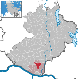
| Location of the municipality of Lütau in the Duchy of Lauenburg district | ||
  |
||

Lütau is a municipality in the Duchy of Lauenburg in Schleswig-Holstein .

geography
Lütau is located in the southeast of Schleswig-Holstein on the federal highway 209 between Schwarzenbek and Lauenburg.
history
The village of Lütau in the Sadelbande was first mentioned in a document in the Ratzeburg tithe register from 1230.
The entry in the tithe register of 1230 by Bishop Gottschalk von Ratzeburg (1229–1235) shows that the parish and the German village of Lütau existed before 1164. It is noted that Lütau was made titan by Count Reinhold. After this Count Reinhold was killed in the battle of Demmin in 1164 , the tithe of Lütau became free for the bishop.
Lütau was planned by German settlers when they occupied the Polabian territory during the colonization period of the 12th century . However, there are indications that Lütau is much older. The original name ( Lutowe ) suggests that it was founded by a Slavic farmer who gave the settlement his name (or nickname). Lutowe or Old Polish * L'utov can be freely translated as “place des L'ut” or “village of the wild man”.
Research considers it possible that the original Slavic village of Lütau, before the colonization period, was located at the point that is referred to in the Lütau land map from 1722 as "in front of the Wendfeld " and that is directly north of the Linau at the Wangelauer Scheide next to the hallway " Up dem olden Felde " is located. In addition, research is also considering the development of the Wendfeld as a separate settlement for the Slavs who were resettled from their old village only in German times.
After the formation of the offices in 1948, Lütau was the seat of the office of Lütau until an administrative community was formed with the city of Lauenburg / Elbe in 1969.
politics
Community representation
Of the nine seats in the municipal council, the WGL community of voters has five seats since the 2016 local elections and the Lütauer Bürgerervereinigung LBV four seats.
The mayor is provided by the LBV.
coat of arms
Blazon : “A square golden church tower in green, consisting of a wide, tapering stone substructure with a Gothic portal and pent roof and a half-timbered superstructure with a tented roof. An upright silver hoe is floating to the left of the superstructure. "
Economy and Infrastructure
The municipal utility of Lauenburg is responsible for supplying the community with drinking water and natural gas ; the wastewater is treated in a separate plant.
Lütau runs a kindergarten together with the Wangelau community .
Approx. 200 pupils from the communities belonging to the Lütau School Association attend the Lütau elementary school. Many students from the closed Gülzow primary and secondary school switched to Lütau primary school in 2009. In the course of the Schleswig-Holstein school reform, the secondary school in Lütau expired.
There are still a good ten full-time farms in Lütau. In addition, there are also small craft and commercial enterprises, as well as a food wholesaler, a manufacturer of household goods and a sweet cider, whose products are sold nationwide.
The local cultural life is mainly determined by the local associations (volunteer fire brigade, sports club SpVgg. Lütau and shooting club).
Attractions
The list of cultural monuments in Lütau includes the cultural monuments entered in the list of monuments of Schleswig-Holstein.
The draft horse museum, which has existed on the historic Annenhof since 2000, deals with the cultural history of the workhorse .
Web links
Individual evidence
- ↑ North Statistics Office - Population of the municipalities in Schleswig-Holstein 4th quarter 2019 (XLSX file) (update based on the 2011 census) ( help on this ).
- ^ W. Prange: Settlement history of the state of Lauenburg in the Middle Ages, sources and research on the history of Schleswig-Holstein. Society for Schleswig-Holstein History (Ed.), Vol. 41, Neumünster 1960, p. 63 f. and p. 352
- ^ W. Prange: Settlement history of the state of Lauenburg in the Middle Ages, sources and research on the history of Schleswig-Holstein. Society for Schleswig-Holstein History (Ed.), Vol. 41, Neumünster 1960, p. 358
- ^ W. Prange: Settlement history of the state of Lauenburg in the Middle Ages, sources and research on the history of Schleswig-Holstein. Society for Schleswig-Holstein History (Ed.), Vol. 41, Neumünster 1960, p. 126 f.
- ↑ Schleswig-Holstein's municipal coat of arms
Albsfelde | Alt-Mölln | Aumühle | Bäk | Blue | Basedow | Basthorst | Behlendorf | Berkenthin | Besenthal | Bliestorf | Exchanges | Borstorf | Breitenfelde | Bröthen | Brunsmark | Brunstorf | Books | Buchholz | Buchhorst | Dahmker | Dalldorf | Dassendorf | Düchelsdorf | Duvensee | Single house | Elmenhorst | Escheburg | Fitzen | Fredeburg | Fuhlenhagen | Geesthacht | Giesensdorf | Göldenitz | Goddess | Grabau | Grambek | Grinau | Big floor | Great Disnack | Groß Grönau | Great Pampau | Great Sarau | Groß Schenkenberg | Grove | Gudow | Gülzow | Bream | Hamfelde | Hamwarde | Harmsdorf | Havekost | Hohenhorn | Hollenbek | Hornbek | Horst | Juliusburg | Kankelau | Kasseburg | Kastorf | Kittlitz | Klein Pampau | Klein reveler | Plumbing | Klinkrade | Koberg | Kollow | Koethel | Kröppelshagen-Fahrendorf | Krukow | Curved mass | Krüzen | Kuddewörde | Killing | Kulpin | Labenz | Langenlehsten | Lankau | Lance | Lauenburg / Elbe | Clay wheel | Linau | Lüchow | Lütau | Mechow | Möhnsen | Mölln | Mill wheel | Must | Mustin | Niendorf ad St. | Niendorf near Berkenthin | Nuts | Panting | Pogeez | Poggensee | Ratzeburg | Ritzerau | Römnitz | Rondeshagen | Roseburg | Sahms | Salem | Sandesneben | Schiphorst | Schmilau | Schnakenbek | Schoenberg | Schretstaken | Schulendorf | Poking soles | Schwarzenbek | Seedorf | Seven trees | Seven oaks | Sierksrade | Sirksfelde | Steinhorst | Sterley | Stump | Talkau | Tramm | Walksfelde | Wangelau | Wentorf (Amt Sandesneben) | Wentorf near Hamburg | Wiershop | Witzeeze | Wohltorf | Woltersdorf | Worth | Ziethen
Community-free area in the Duchy of Lauenburg
Sachsenwald district