
Romnitz
| coat of arms | Germany map | |
|---|---|---|

|
Coordinates: 53 ° 43 ' N , 10 ° 46' E |
|
| Basic data | ||
| State : | Schleswig-Holstein | |
| Circle : | Duchy of Lauenburg | |
| Office : | Lauenburg lakes | |
| Height : | 27 m above sea level NHN | |
| Area : | 5.15 km 2 | |
| Residents: | 58 (Dec. 31, 2019) | |
| Population density : | 11 inhabitants per km 2 | |
| Postal code : | 23909 | |
| Area code : | 04541 | |
| License plate : | RZ | |
| Community key : | 01 0 53 102 | |
| LOCODE : | DE 54Y | |
| Office administration address: | Fünfhausen 1 23909 Ratzeburg |
|
| Website : | ||
| Mayor : | Karl Guse | |
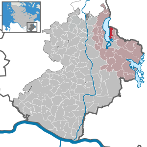
| Location of the municipality of Römnitz in the Duchy of Lauenburg | ||
  |
||

Römnitz is a municipality in the Duchy of Lauenburg in Schleswig-Holstein on the east bank of Lake Ratzeburg . Hohenlicht and Kalkhütte are in the municipality.
history
Römnitz was founded around 800 years ago in the Middle Ages and was formerly referred to as the "village of the funny people / village of the funny brothers". As early as 1194, Römnitz was first mentioned in a document as Rodemozle in the Isfried partition contract .
The former Mecklenburg community had belonged to the British zone of occupation since 1945 ( Barber-Lyaschtschenko Agreement ) and thus to the Federal Republic of Germany since 1949. The town center is still shaped today by the Römnitz domain, a Mecklenburg state domain of 231 hectares , which was administered by the Federal Republic of Germany until 1990. Before the Barber-Lyashchenko Agreement, the land reform had already been carried out on the domain in September 1945 , during which a total of 29 settlers were each allocated around 20 acres . However, the British occupying power saw the domain property as having been confiscated under Military Government Act No. 52 and, as in the following district and country, the land reform as void, at least with regard to the transfer of property, which led to lengthy negotiations with the settlers and legal disputes up to Federal Court of Justice led. From 1961 on, severance negotiations began with the settlers, which were successfully concluded in 1964.
politics
Since the community has fewer than 70 inhabitants, it has a community assembly instead of a community council; this includes all citizens of the community.
traffic
There is a direct road connection to the Hanseatic city of Lübeck and the district town of Ratzeburg . There is bus service to Mechow , Bäk and Ratzeburg.
In addition, Römnitz can be reached by boat traffic on the Ratzeburger See and numerous hiking trails lead directly around the Ratzeburger See.
Web links
- Literature about Römnitz in the state bibliography MV
- Römnitz community at the Lauenburg Lakes Office
Individual evidence
- ↑ North Statistics Office - Population of the municipalities in Schleswig-Holstein 4th quarter 2019 (XLSX file) (update based on the 2011 census) ( help on this ).
- ↑ Schleswig-Holstein topography. Vol. 8: Pölitz - Schönbek . 1st edition Flying-Kiwi-Verl. Junge, Flensburg 2007, ISBN 978-3-926055-89-7 , pp. 198 ( dnb.de [accessed on July 23, 2020]).
- ^ Sabine Bock : Stately houses on the estates and domains in Mecklenburg-Strelitz. Architecture and history. (= Contributions to the history of architecture and monument preservation, 7.1–3), Thomas Helms Verlag Schwerin 2008, ISBN 978-3-935749-05-3 , Volume 2, pp. 791–794.
- ↑ digitized version
- ↑ Klaus von der Groeben : The Mecklenburg property assets in the communities of Ziethen, Mechow, Bäk and Römnitz. History of the change of area and the trust management since 1945. Bonn-Bad Godesberg: Klassenausgleichsbank [1982], p. 39 ff.

Albsfelde | Alt-Mölln | Aumühle | Bäk | Blue | Basedow | Basthorst | Behlendorf | Berkenthin | Besenthal | Bliestorf | Exchanges | Borstorf | Breitenfelde | Bröthen | Brunsmark | Brunstorf | Books | Buchholz | Buchhorst | Dahmker | Dalldorf | Dassendorf | Düchelsdorf | Duvensee | Single house | Elmenhorst | Escheburg | Fitzen | Fredeburg | Fuhlenhagen | Geesthacht | Giesensdorf | Göldenitz | Goddess | Grabau | Grambek | Grinau | Big floor | Great Disnack | Groß Grönau | Great Pampau | Great Sarau | Groß Schenkenberg | Grove | Gudow | Gülzow | Bream | Hamfelde | Hamwarde | Harmsdorf | Havekost | Hohenhorn | Hollenbek | Hornbek | Horst | Juliusburg | Kankelau | Kasseburg | Kastorf | Kittlitz | Klein Pampau | Klein reveler | Plumbing | Klinkrade | Koberg | Kollow | Koethel | Kröppelshagen-Fahrendorf | Krukow | Curved mass | Krüzen | Kuddewörde | Killing | Kulpin | Labenz | Langenlehsten | Lankau | Lance | Lauenburg / Elbe | Clay wheel | Linau | Lüchow | Lütau | Mechow | Möhnsen | Mölln | Mill wheel | Must | Mustin | Niendorf ad St. | Niendorf near Berkenthin | Nuts | Panting | Pogeez | Poggensee | Ratzeburg | Ritzerau | Römnitz | Rondeshagen | Roseburg | Sahms | Salem | Sandesneben | Schiphorst | Schmilau | Schnakenbek | Schoenberg | Schretstaken | Schulendorf | Poking soles | Schwarzenbek | Seedorf | Seven trees | Seven oaks | Sierksrade | Sirksfelde | Steinhorst | Sterley | Stump | Talkau | Tramm | Walksfelde | Wangelau | Wentorf (Amt Sandesneben) | Wentorf near Hamburg | Wiershop | Witzeeze | Wohltorf | Woltersdorf | Worth | Ziethen
Community-free area in the Duchy of Lauenburg
Sachsenwald district