Güster (Lauenburg)
| coat of arms | Germany map | |
|---|---|---|

|
Coordinates: 53 ° 32 ' N , 10 ° 41' E |
|
| Basic data | ||
| State : | Schleswig-Holstein | |
| Circle : | Duchy of Lauenburg | |
| Office : | Books | |
| Height : | 23 m above sea level NHN | |
| Area : | 7.78 km 2 | |
| Residents: | 1300 (Dec. 31, 2019) | |
| Population density : | 167 inhabitants per km 2 | |
| Postal code : | 21514 | |
| Area code : | 04158 | |
| License plate : | RZ | |
| Community key : | 01 0 53 048 | |
| Office administration address: | Amtsplatz 1 21514 Büchen |
|
| Website : | ||
| Mayor : | Wilhelm Burmester (KWG) | |
| Location of the municipality of Güster in the Duchy of Lauenburg | ||
Güster is a municipality in the Duchy of Lauenburg in Schleswig-Holstein . Güster has no other districts.
geography
The community is located on the Elbe-Lübeck Canal, 10 km northeast of Büchen .
history
The name Güster or Guztrade comes from the Slavic word: Gostirady (Gost comes from the Slavic word for guest).
In 1230 Güster was first mentioned in the Ratzeburg tithe register as "Guztrade" with 14 hooves. However, urn finds from 1911 and 1930 indicate an older settlement. Güster was a typical round village with only one exit to the west and the closed side to the dolphin valley in the east. The second mention of the farming village took place in 1345, when a Möllner citizen donated ten talers from his income from Güster for the Marien Altar.
The taxes of the Güsteraner farmers were recorded in the bed registers of the early 16th century. Since then the village has belonged to the Dalldorfs in Wotersen . During the Thirty Years' War (after 1648) the Dalldorfs merged four devastated hooves into a sheep farm. When the male line of the Dalldorfs died out in 1714, Güster came into the possession of the Bernstorffs .
Güster was on the Delvenau-Stecknitz Canal, built between 1391 and 1398, the "wet salt road" to Lübeck. However, this did not bring the town any major economic gains. In 1880, Güster was a pure farming village with around 20 houses and 776 hectares.
During the construction of the Elbe-Lübeck Canal (1896–1900), significant deposits of gravel were discovered in the community. In addition to the cheap waterway, the proximity to the Lübeck-Büchen railway line also gained importance in terms of transport. At the turn of the century, the Hanseatic city of Hamburg began to expand and expand by leaps and bounds. A market with a high demand for gravel for construction projects was created in Hamburg, just 50 kilometers away. Gravel from Güster has been used throughout northern Germany. Major projects were: Spitalerstrasse and Mönckebergstrasse in Hamburg, the Walddörferbahn, the station building in Lübeck, the torpedo boat port in Cuxhaven, the fortification of Heligoland, the expansion of the Kiel Canal and the Hamburg-Lübeck motorway.
In 1911, 40 to 50 ships passed the canal every day. In 1912 the number of outgoing ships was already 1797 with a loading capacity of almost 750,000 tons. The actual cargo carried was around 650,000 tons. At that time, Güster was the third most popular port in Germany in inland waterway traffic and was only surpassed by Duisburg and Berlin.
In 1981 the last gravel extraction company was closed. The exploited gravel area has gradually been renatured, and around 1950 tourism began with Hamburg weekend and holiday guests looking for relaxation at the lakes.
With over 900 parking spaces for camping and over 350 weekend homes and other accommodations, Güster is one of the most popular recreational areas east of Hamburg today. Last but not least, the convenient connection to the Hamburg – Berlin autobahn, which opened in 1982, favored this development.
During the renaturation of the inland lakes exposed by gravel mining, the bank areas and the water body were almost completely privatized. The result was a living space with residential buildings directly on the lake and ecological quiet zones, in which a variety of plants and animals, some of which are rare, have now established themselves.
politics
Community representation
Of the eleven seats in the local council have the CDU and the voter community KWG since the local elections in 2008 four seats, the SPD two and the FDP has a seat.
coat of arms
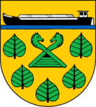
Blazon : “Five upright green linden leaves set in gold 2: 2: 1, which enclose a green gable end with a black owl hole ending in two turned horse heads; Above it a black barge with a silver driver's cab, silver oar and silver gravel load, the lower third of which is covered by a blue bar. "
The gable end gives an indication of the rural past of the place. The linden leaves stand for the linden trees in the center of the village and the barge refers to the Elbe-Lübeck Canal.
Web links
Individual evidence
- ↑ North Statistics Office - Population of the municipalities in Schleswig-Holstein 4th quarter 2019 (XLSX file) (update based on the 2011 census) ( help on this ).
- ↑ Schleswig-Holstein topography. Vol. 4: Groß Sarau - Holstenniendorf . 1st edition Flying-Kiwi-Verl. Junge, Flensburg 2004, ISBN 978-3-926055-75-0 , p. 69 ( dnb.de [accessed on May 1, 2020]).
- ↑ Schleswig-Holstein's municipal coat of arms


