Elbe-Lübeck Canal
| Elbe-Lübeck Canal | |
|---|---|
|
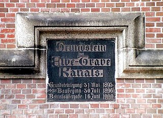
Foundation stone of the canal |
|
| abbreviation | ELK |
| location |
|
| length | 61.55 km |
| Built | 1895-1900 |
| class | Inland waterway class III |
| Beginning | Lauenburg / Elbe |
| Parting posture | Witzeeze |
| The End | Trave in Lübeck |
| Descent structures | Lauenburg, Witzeeze, Donnerschleuse, Behlendorf, Berkenthin, Krummesse, Büssau |
| Ports | Lauenburg, Mölln , Lübeck |
| Historical precursors | Stecknitz Canal |
| Kilometrage | From the Elbe to the Trave |
| Top speed. | 10 km / h |
| Ascent | Towards the Elbe |
| Competent authority | WSA Lauenburg |
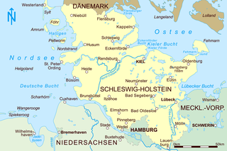
The Elbe-Lübeck Canal (ELK, 1900-1936: Elbe-Trave Canal ) is a 61.55 km long federal waterway of class III from Lauenburg / Elbe near Elbe-Km 569.23 to Lübeck in the state of Schleswig-Holstein . It represents a connection for inland shipping between the Elbe and the Baltic Sea . The Lauenburg Waterways and Shipping Office is responsible .
history

The forerunner of the Elbe-Lübeck Canal is the historic Stecknitz Canal , which was built between 1391 and 1398 by the Lübeckers along the Stecknitz and Delvenau rivers . Their old routes can still be seen in some places to the left and right of today's Elbe-Lübeck Canal. This canal had 17 locks (initially flood locks , later as chamber locks ) over a length of 97 kilometers and was the first real watershed canal in Europe. Of the locks, the palm lock in Lauenburg and the Dückerschleuse (water lock ) at Witzeeze are still preserved. This waterway remained in operation for almost 500 years until construction of the ELK began.
The foundation stone of the canal, seen by the Lübeckers as a competitor to the Kaiser Wilhelm Canal, was ceremoniously laid on May 31, 1895 and built according to the plans of the Lübeck building director Peter Rehder . Mayor Heinrich Klug put it into operation on June 16, 1900 in the presence of the Emperor in Lübeck. The Stecknitz and Delvenau have largely risen up in the Elbe-Lübeck Canal. The inland waterway, known as the Elbe-Trave Canal until 1936, shortened the distance to 62 kilometers, the number of locks fell to seven and the journey time to around eight hours. A technology that was very advanced for the time and has proven itself to the present day, with locks and generously dimensioned bridges designed by building inspector Ludwig Hotopp , operated purely hydrodynamically (only by water power), made the canal appear exemplary for a long time.
The building deputation of the Hanseatic City of Lübeck sent its city gardener, Metaphius Theodor August Langenbuch , to the International Horticultural Exhibition in Berlin in 1885 in order to expand his knowledge and gather ideas. The Friedrichshain gave him the suggestion how one could embellish the part at the old city moat near the observatory by partially filling the moat and creating a water surface up to the edges of the planted lake-like valley. Almost twenty years later he carried out this idea, albeit in a different way, when building the Elbe-Trave canal. The creation of new horticultural facilities for the canal construction in the years 1897 to 1900, a reed belt with its roots fortified the banks in a natural way, was one of his greatest works in addition to the creation of the Lübeck city park . Over time, the waterway was used by more and more motor ships, whose propulsion power and speed placed greater demands on the canal bed. Backflowing water tore loose bales of thatch and washed them away. With the loss of this valuable bank vegetation, erosions ( scour ) and bank breaks developed. The ground settled on the bottom and thereby reduced the depth of the fairway. Elevations of up to 30 cm were created and the risk of the ships hitting the ground. As a result, bed excavations had to be carried out more and more often. To secure the banks, the then water and shipping authority Lauenburg developed a structurally and ecologically sensible bank protection. It consists of a row of pine piles that were driven so deep that the pile heads end 20 cm below the surface of the water. In this way it was achieved that the vegetation in the water transition zone is hardly disturbed by the row of piles. The animal world, such as fish and frogs, can enter the bank belt without any obstacles. The broken bank behind the pile wall was refilled with soil. To prevent the soil from flowing out through the row of piles, a filter mat was attached to the back of the piles.
As the only German canal of this era besides the Kaiser Wilhelm Canal , the Elbe-Lübeck Canal was designed for 1000-ton ships from the start. The seven locks between the Elbe and the Baltic Sea across the apex stretch near Mölln , which is around twelve meters higher than the Trave, ensure a constant canal water level. They are each designed for two ships 8 meters wide and up to 80 meters long (or at that time for 65-meter-long barges in tug formation), only the Lauenburg lock, which was renovated in 2006 with 40 million euros, was expanded for 115 m long ships.
The construction and maintenance of the canal was near Lübeck from 1895 to 1921. In 1921 the canal from the Geniner Bridge in Lübeck to the Elbe became Reichswasserstraße. The Trave ( Canal Trave ), which was built beneath the Geniner Bridge when the canal was built , only became Reichswasserstraße in 1934.
Traffic to and from Lübeck increased rapidly in the canal's first years of operation. In 1902 it was 207,001 tons , in 1905 it was 360,204 tons, and in 1909 it was already 505,115 tons. Initially, the Elbe-Trave Canal was mainly used for the transport of bulk goods , in the direction of Lübeck these were mainly fertilizers , stones and earth, bricks , pipes, sand , gravel , chalk, oilseeds, sugar, molasses, syrup, salt and bark , Tanning agents, cut wood, stones and stone ware, petroleum and other oils, fruits and chemicals. In the opposite direction, primarily wood (cut and trunk wood), raw and broken iron, stone and stone goods, legumes, cellulose, coke , coke breeze, oils and fats as well as molasses and oats were transported. The gravel deposits found during the construction of the canal in the area of Güster in the Duchy of Lauenburg soon contributed significantly to the canal traffic.
On March 25, 1903, as the Lübeck newspapers of the time reported enthusiastically, the torpedo boat S 65 was the first warship to cross the canal. With the passage of the boat, it was proven that the canal would serve the Imperial Navy in an emergency, despite its seven locks and numerous bridges .
Today's meaning
The current importance of the canal is rather minor, as the lock and bridge dimensions, which are small for the present time, do not allow economical container transport and only smaller inland vessels up to a unloading of 1000 t can pass through the canal. In addition, the canal is also used by sports boats in traffic between the Baltic Sea and the Elbe (approx. 5000–6000 boats per year).
In the Federal Transport Infrastructure Plan 2030 presented by the Federal Minister for Transport and Digital Infrastructure , Alexander Dobrindt , on August 3, 2016 , the largest single project in Schleswig-Holstein was the Elbe-Lübeck Canal, which was funded by the federal government with investments of 800 million euros in its infrastructure . Since the Federal Transport Infrastructure Plan 2030 has determined a benefit-cost ratio of 0.5, further expansion is controversial. The expansion was stopped in 2020.
Channel levels
| Lock chamber | ||||||
|---|---|---|---|---|---|---|
| Channel level | Channel km | Water level | length | width | Height of fall | Length of the sewer line |
| Trave | 0.00 | Above sea level ± 0.00 m | ||||
| Büssau (with weir) | 3.43 | Above sea level +1.50 m | 80.5 m | 17.0 m * | 1.50 m | 5.12 km |
| Curved mass | 8.55 | Above sea level +4.25 m | 80.5 m | 17.0 m * | 2.75 m | 4.78 km |
| Berkenthin | 13.33 | Above sea level +6.00 m | 80.5 m | 17.0 m * | 1.75 m | 3.19 km |
| Behlendorf | 16.52 | Above sea level +7.65 m | 80.5 m | 17.0 m * | 1.65 m | 4.15 km |
| Thunder Lock | 20.67 | Above sea level +11.83 m | 80.5 m | 17.0 m * | 4.18 m | 29.78 km |
| Witzeeze | 50.45 | Above sea level +11.83 m | 80.5 m | 17.0 m * | 2.98 m | Parting posture |
| Lauenburg (with weir) | 59.91 | Above sea level +8.85 m | 115.0 m | 12.5 m | 4.85 m | 9.50 km |
| Elbe | 61.55 | Above sea level +4.00 m | * Door width 12.0 m |
|||

The combination of lock operating times and permissible maximum speed (4 km / h in the Lauenburg port and from the lock to the Elbe, otherwise between 6 and 10 km / h depending on the loading depth and vehicle width ) enables the route from the Elbe to Lübeck to be covered in one Day to cover.
The importance of the ELK for commercial shipping has been declining for years: in 1968 17,602 ships carried 2.524 million t of goods here, in 1998 there were 3,160 ships with 1.103 million t, in 2018 there were only 1,220 ships with 585,715 t of cargo. In 2016 a small river cruise ship ( Princess of the Dutch Cruise Line ) sailed from Lauenburg through the canal for the first time , whereby the upper deck had to be cleared for bridge crossings. The Lauenburg lock was also used by 3523 pleasure boats in 2018.
The bridge clearance height is 4.4 m with normal canal water level and is to be increased to 5.25 m in the next few years. The unloading depth is max. 2.0 m.
The six locks from 11 km before the end of the canal near Lauenburg, which can only accommodate ships up to 80 meters in length, are a limiting factor for shipping.
In addition, recreational use for local recreation and tourism has grown in recent years. The canal's riverside paths are suitable for (cycling) hikes between Lübeck ( Geniner Bridge ) and Lauenburg (alternating with the historic Old Salt Road, which runs parallel through the Lauenburg Lakes Nature Park ) and thus open up the cycle paths on the Elbe and in the Lüneburg Heath .
Cities and communities on the Elbe-Lübeck Canal
- Lübeck , 71 m north-east of the axis of the Genin road bridge, the ELK begins at km 0.00, shortly afterwards the Lübeck – Hamburg line crosses the canal , and a little further on the federal motorway 20
- Lübeck , district of Büssau with lock at km 3.43
- Krummesse with lock at km 8.55
- Berkenthin with lock at km 13.33 (this is also where federal road 208 crosses )
- Behlendorf with lock at km 16.52
- Neu Lankau with the Donnerschleuse at km 20.67
- Mölln (here the federal road 207 crosses the canal that runs through the Möllner Ziegelsee )
- Güster , this is where the federal highway 24 crosses . The canal is lined here by a number of quarry ponds, some of which are also accessible from the canal. The gravel extracted here was removed via the ELK. Today the lakes are mainly used for local recreation.
- Seven oaks with a ferry connection to Fitzen
- Books
- Witzeeze with lock at km 50.45
- Dalldorf with bridge to Zweedorf (Schwanheide)
- Basedow (Lauenburg) am Lanzer See at km 55 (the canal runs along Lanzer See)
- Lauenburg / Elbe with lock at km 59.91 (here the federal highway 5 crosses the canal), confluence with the Elbe at km 61.55
Geospatial data
- Start of kilometrage: 53 ° 50 ′ 37 ″ N , 10 ° 38 ′ 5 ″ E
- Confluence with the Elbe near Lauenburg: 53 ° 22 ′ 10 ″ N , 10 ° 33 ′ 27 ″ E
literature
- Karin Brundies, Harald Utecht: Elbe . Volume 3: ESK + ELK. From Magdeburg to Artlenburg, from MLK to Travemünde . DSV-Verlag, Hamburg 1999, ISBN 3-88412-306-8 ( inland waterways 6).
- Hans-Georg Braun, Hans Rohde, Burkart Rümelin, Walter Strähler, Hans-Joachim Ullmann: Rivers and canals . The history of the German waterways. Ed .: Martin Eckoldt. 1st edition. DSV-Verlag, Hamburg 1998, ISBN 3-88412-243-6 , chapter 8.6, p. 351/352 .
- Emil Hammermann: The Elbe-Trave Canal . Gustav Fischer Publishing House, Jena 1914 ( digital copy )
- Waterways and Shipping Directorate North: Elbe-Lübeck Canal, maintenance of a waterway . Self-published, Kiel 1990, ISBN 3-88412-243-6 .
Web links
- Arthur Oelwein: The Elbe-Trave-Canal. In: Weekly of the Austrian Association of Engineers and Architects , year 1891, No. 35/1891 (XVI. Year), p. 313 f. (Online at ANNO ). .
- Elbe-Lübeck Canal: From a trade route to a tourist oasis
- Elbe-Lübeck Canal on the website of the Waterways and Shipping Office Lauenburg
- The Elbe-Trave Canal. For the opening ceremony on June 16, 1900
- Photos from the Elbe-Lübeck Canal
- Inauguration of the new Lauenburg ship lock in 2006 with the passage of the paddle steamer "Kaiser Wilhelm"
Individual evidence
- ↑ a b Lengths (in km) of the main shipping lanes (main routes and certain secondary routes) of the federal inland waterways ( Memento of the original from January 21, 2016 in the Internet Archive ) Info: The archive link was automatically inserted and not yet checked. Please check the original and archive link according to the instructions and then remove this notice. , Federal Waterways and Shipping Administration
- ↑ Directory E, serial no. 11 der Chronik ( Memento of the original from July 22, 2016 in the Internet Archive ) Info: The archive link was inserted automatically and has not yet been checked. Please check the original and archive link according to the instructions and then remove this notice. , Federal Waterways and Shipping Administration
- ↑ Local and mixed notes. In: Lübeckische Blätter , Volume 27, No. 74, Edition of September 16, 1885, p. 424.
- ↑ The first warship on the Elbe-Trave Canal. In Vaterstädtische Blätter , issue of April 12, 1903
- ↑ Andreas Dohms: The Elbe-Lübeck Canal - a direct waterway connection between the open sea and the inland . In: Binnenschifffahrt Heft 12 (2009) pp. 68–72.
- ↑ BVWP overall plan (August 3, 2016) (PDF 11 MB) ( Memento of the original of August 3, 2016 in the Internet Archive ) Info: The archive link has been inserted automatically and has not yet been checked. Please check the original and archive link according to the instructions and then remove this notice.
- ^ Project W 33 Expansion of the Elbe-Lübeck Canal at www.bvwp-projekte.de, accessed on November 14, 2018
- ↑ Elbe-Lübeck Canal: Doubts about the billion- dollar project are growing on www.shz.de, article from October 19, 2017, accessed on November 14, 2018
- ↑ Federal government is slowing down the expansion of the Elbe-Lübeck Canal
- ↑ a b c Inland Waterways Regulations , Chapter 19: ELK and Trave
- ↑ A canal in deep slumber · The future of the Elbe-Lübeck Canal is completely open despite many ideas and perspectives. In: Daily port report of October 30, 2019, special supplement No. 12 Schleswig-Holstein Harbor Day , pp. 4–7
- ↑ Oliver Vogt: No future for the canal? In: Lübecker Nachrichten of November 24, 2010, p. 6
Coordinates: 53 ° 36 ' N , 10 ° 41' E


