
Schwanheide
| coat of arms | Germany map | |
|---|---|---|

|
Coordinates: 53 ° 26 ' N , 10 ° 41' E |
|
| Basic data | ||
| State : | Mecklenburg-Western Pomerania | |
| County : | Ludwigslust-Parchim | |
| Office : | Boizenburg country | |
| Height : | 18 m above sea level NHN | |
| Area : | 26.51 km 2 | |
| Residents: | 732 (Dec. 31, 2019) | |
| Population density : | 28 inhabitants per km 2 | |
| Postal code : | 19258 | |
| Area code : | 038842 | |
| License plate : | LUP, HGN, LBZ, LWL, PCH, STB | |
| Community key : | 13 0 76 122 | |
| LOCODE : | DE CWH | |
| Community structure: | 2 districts | |
| Office administration address: | Fritz-Reuter-Str. 3 19258 Boizenburg / Elbe |
|
| Website : | ||
| Mayor : | Stefanie Humpke | |
| Location of the municipality of Schwanheide in the Ludwigslust-Parchim district | ||
  |
||

Schwanheide is a municipality in the Ludwigslust-Parchim district in Mecklenburg-Western Pomerania (Germany). It is administered by the Boizenburg-Land Office , based in the non-official city of Boizenburg / Elbe . The municipality is divided into the districts of Schwanheide and Zweedorf. The Bauerende, Neuendamm and Zweedorfer Tannen settlements belong to the Schwanheide district.
Geography and transport links
_Zweedorf_(MV)_Stecknitz_(Delvenau)_ex_Grenzstreifen_2010-12-01_015.JPG)
Schwanheide is located in the west of Mecklenburg-Western Pomerania about six kilometers northwest of Boizenburg and borders on Schleswig-Holstein . The Mühlenbach runs through the municipality, and the Riedebeck on the northwestern municipal boundary . At the western boundary of the municipality, the Delvenau flows through the Stecknitz-Delvenau nature reserve south towards the Elbe. Gravel mining resulted in four lakes between Schwanheide and Zweedorf. The community has a stop on the Berlin – Hamburg railway line .
history
Schwanheide
Surname
The name is derived from the location on the western edge of the historic Schwanenheyde . This stretched from Leisterförde in the north to Gehrum in the south and in the west-east extension from Mühlenbach over the subsequent Boizenburger Heyde to Boize . The Boizenburg freight route ran along the eastern edge of the Schwanenheyde , on which the Lüneburg salt stacked in Boizenburg was transported by land via Fredeburg to Lübeck .
middle Ages
The Landesbederegister mentions a settlement of the Schwanenheyde with a Meierhof for the first time in 1560 . This was operated by the tenant as a sheep farm. A village did not yet exist. About 1 km further south was the Schwanheyder Mühl on the Mühlenbach , formerly a mill in the lost village of Kladrum .
17th-19th century
From 1704 to 1714 the Grand Ducal Mecklenburg Meierhof was owned by the Privy Council and Chamber President Friedrich von Graevenitz . Then it was leased to Hinrich Siemers until 1722, then to Valentin Kauffeldt until after 1751. In the middle of the 19th century, the northern areas of the Meierhof up to the Piperkaten with 6 hereditary lease hooves and a Büdnerei were settled, which were given the designation Bauernende. Only with this settlement did a village emerge, which then expanded rapidly in 1886 with the establishment of the stop on the Berlin – Hamburg railway line .
Modern times
In 1921 Schwanheide is spun off from the municipality of Zweedorf and becomes an independent municipality. One year later, Neuendamm, which had previously belonged to Boizenburg, was moved to Schwanheide.
On May 20, 1925, the Schwanheide volunteer fire brigade was founded.
The Schwanheide station was during the division of Germany border station at the time in transit used Berlin-Hamburg route .
The chapel in Schwanheide was built from wood in the 1960s based on the Swedish model. The wooden belfry was built in 1991. The bell, cast in 1651, comes from the demolished church in Zweedorf. Schwanheide was always parish in Zweedorf.
Zweedorf
Surname
Zweedorf was first mentioned in a document in 1252 as Twedorp . The name is said to have originated from the union of the two villages Borgstorf and Kladrum ("Zweidorf"). In contrast, Wieben has pointed out that the Boizenburg councilor Henricus de Thvedorp, documented for the year 1241, comes from Zweedorf, which is why a name based on an ancestor of this Heinrich von Zweedorf - as a ministerial locator from the entourage of Henry the Lion - is being considered got to.
middle Ages
Zweedorf is located in a former strip of wasteland immediately east of the Limes Saxoniae . In the Middle Ages, this strip of wasteland ran along the Delvenau and stretched east to the Boize . Whether the area was planned to be kept free from settlement or whether mainly geomorphological reasons were decisive has not yet been conclusively researched. In the absence of Slavic ceramic finds, it has so far been assumed that the sand area between Delvenau and Boize had at most a sparse Slavic settlement until 1143. Current excavation results, however, suggest continuous Slavic settlement since the 8th century.
The village was laid out as a cul-de-sac village on a headland of the Sanders that was pushed into the dolphin low as part of the high medieval development of the country . The only access route led to the east to the arable land, the cul-de-sac pointed to Delvenau. Zweedorf originally had a size of at least 16 hooves : In 1252 Gunzelin , Count von Schwerin, gave 9 hooves in Zweedorf to the Zarrentin monastery , which had previously bought it from the citizen Wichfried from Wittenburg . In 1279 the monastery already owned 14 Hufen and a large number of Kossatenstellen and in 1297 Nikolaus, Count von Schwerin, gave away 2 Hufen land in Zweedorf along with extensive privileges to the church in Boizenburg. In the same year he sold the rest of the village "with all living and dead inventory" to the Zarrentin monastery. A church in Zweedorf is mentioned for the first time in 1335. In 1496, Zweedorf was one of the largest villages in the Boizenburg Bailiwick with 64 adults and 38 children under the age of 15. After the dissolution of the Zarrentin monastery in 1552, Zweedorf came into sovereign possession and was from then on administered by the Boizenburg Domanialamt. Despite its hidden location on the edge of the Schwanenheyde and away from the Boizenburg freight route, Zweedorf was not spared the effects of the Thirty Years' War . Of 13 full farmers, 4 kossats and 4 cottagers in 1618, only 7 full farmers remained in 1640, 2 of them on the two hooves of the Boizenburg church. 9 homesteads were devastated. The human losses are not proven.
17th-19th century
Pledged to the Electorate of Hanover in 1734 as a result of the Imperial Execution , the office and village again belonged to Mecklenburg-Schwerin from 1768. After the separation in Mecklenburg - Schwerin was ordered in 1822, farms were gradually relocated to the Zweedorfer Feldmark until 1850. This resulted in the settlement of Neu-Zweedorf on the Bösdäne Weg, roughly at the level of the submerged village of Borgstorf. At the same time, Büdnereien were built on the vacated land in the local area of Zweedorf. In 1890 a Hamburg entrepreneur began mining gravel on the southern edge of the village, which permanently and fundamentally redesigned the Feldmark. Sand and gravel were transported with a lorry to the Berlin – Hamburg line, where they were reloaded onto freight trains and shipped to Hamburg as building materials for the expansion of the port, the main train station and the Tiefstack freight station, among other things. Urn finds made in the course of the gravel mining in the 1890s prove that the place was already settled in the younger Bronze Age.
Modern times
In 1919 a consortium of companies set up an ammunition dismantling plant northeast of the village, which temporarily employed up to 300 workers from Mölln and Lauenburg. From 1924 ammunition was manufactured there under the strictest of secrecy as part of the rearmament. The area is still closed to this day.
In May 1945 British troops first occupied Zweedorf, after their withdrawal in July the Soviet Army. From 1947 on, police were stationed alongside the Soviet soldiers to monitor the border in Zweedorf. With the withdrawal of the soldiers, the first company building for the German border police was erected on Bösdkörpers Weg . As part of the Vergeziefer campaign in June 1952, the residents of Neu-Zweedorf, a large number of the residents of the resettlers' farms established 100 years earlier and residents of the village were forcibly evacuated. A total of 9 farming and 5 working-class families were evacuated. Others escaped being abducted or arrested by fleeing to the West. The courtyards fell into disrepair and were leveled. The move to Zweedorf and the construction of new buildings was prohibited. Moving into vacant houses was not permitted; these were demolished. The Zweedorf fire brigade was dissolved and the Schwanheider volunteer fire brigade was incorporated as the second fire brigade. On February 25, 1965, Zweedorf lost its independence and was incorporated into Schwanheide. The Zweedorfer church was on 18./19. Demolished November 1978 because the GDR regime feared that the building could be used as a hiding place by potential refugees due to its proximity to the inner-German border. In 1982 the rectory was demolished. In 2009 the construction of a new Zweedorfer chapel started. The inauguration took place on September 4, 2011.
After the fall of the Wall, the remaining villagers tried to regain their old parish status, but failed because of the low population. Due to the influx from Schleswig-Holstein , the district now has a closed location with around 140 inhabitants.
politics
mayor
| Term of office | Surname | place of residence |
|---|---|---|
| until 1953 | Carl Scherner | Schwanheide |
| until 1994 | Helmut Smiatek | Schwanheide |
| 1994-1999 | Albert Simon | Zweedorf |
| 1999-2004 | Helmut Smiatek | Schwanheide |
| 2004-2014 | Gerd Altenburg | Schwanheide |
| 2014-present | Stefanie Humpke | Zweedorf |
coat of arms
|
|
Blazon : "In red over two diagonally crossed golden heather branches with silver flowers a ready-to-fly, gold-armored silver swan."
The coat of arms and the flag were designed by Schwanheiderin Heike Müller . It was approved together with the flag on October 6, 2011 by the Ministry of the Interior and registered under the number 338 of the coat of arms of the state of Mecklenburg-Western Pomerania. |
| Reasons for the coat of arms: Historical coat of arms description: The "talking coat of arms" shows a swan and two intersecting heather branches, which are symbolic of the districts of Schwanheide and Zweedorf. The name Schwanheide shows the typical features of the village with sheep breeding, consisting of a heather landscape that is still visible today and a pair of swans at a pond that has now dried up. |
flag

The flag is striped in red, white, red, white and red across the longitudinal axis of the flag. The outer red stripes each take up three twentieth, the white stripe one eighth and the red central stripe nine twentieth of the length of the flag. In the middle of the red central stripe are the figures of the municipality's coat of arms: above two diagonally crossed yellow heather branches with white flowers that take up four-fifteenth of the height of the flag, a ready-to-fly, yellow-armored white swan that takes up two-thirds of the height. The relation of the height of the flag cloth to the length is like 3: 5.
Official seal
The official seal shows the municipal coat of arms with the inscription "GEMEINDE SCHWANHEIDE • LANDKREIS LUDWIGSLUST-PARCHIM".
Attractions
→ See also the list of architectural monuments in Schwanheide .
- Manor house in Schwanheide; single-storey half-timbered building with a crooked hip roof
- Hall houses in Zweedorf
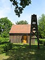
Chapel in Schwanheide (2008)

Schwanheide stop, former border station (2010)

Chapel under construction in Zweedorf (2010)

Manor house in Schwanheide


economy
In the district of Schwanheide there are a few small companies, including those for plant engineering and agricultural products.
Personalities
Gerhard Tolzien (1870–1946), assistant preacher in Zweedorf in 1899 and author of the Zweedorfer church chronicle, later regional bishop of Mecklenburg-Strelitz
Web links
Individual evidence
- ↑ Statistisches Amt MV - population status of the districts, offices and municipalities 2019 (XLS file) (official population figures in the update of the 2011 census) ( help ).
- ↑ § 1 Paragraph 1 of the main statute (PDF; 3.4 MB) of the municipality
- ↑ Sybille Oßwald-Bargende, The mistress, the prince and power. Christina Wilhelmina von Grävenitz and the court society , Campus Verlag, Frankfurt / Main 2000, page 310, fn. 324 weblink
- ↑ Dieter Greve: Field name atlas for southern West Mecklenburg , Volume I, pages 83 and 167, Thomas Helms Verlag, Schwerin 2011 ( ISBN 978-3-940207-25-8 )
- ↑ Website of the Schwanheide volunteer fire brigade
- ↑ Mecklenburgisches Urkundenbuch II, 704
- ↑ Ina Kahns: On the folklore of the state of Mecklenburg using the example of the old Boizenburg office at the beginning of the 20th century, publications by the Research Center for Central Europe at the University of Dortmund, Series B no. 32, editor: Johannes Hoffmann, 1983, page 8.
- ^ Franz Schildt: The submerged villages of Mecklenburg-Schwerins, in: Association for Mecklenburg history and antiquity: Yearbooks of the association for Mecklenburg history and antiquity. - Vol. 56 (1891), pp. 149 - 222 (152f.) Online version ( Memento from February 8, 2011 in the Internet Archive )
- ↑ Richard Hagen and Uwe Wieben: An overview of the history of the city of Boizenburg until 1917, page 8 f., In: Council of the city of Boizenburg (ed.): Boizenburg. Contributions to the history of the city. 1255-1280, Schwerin 1980
- ^ Mecklenburgisches Urkundenbuch Volume I, Certificate No. 529 online version
- ↑ The state of Boizenburg and thus also Zweedorf were directly subordinate to Heinrich the lion from 1143 to 1180: Heike Krause: Slavs and Germans in the states of Wittenburg and Boizenburg. On the German East Settlement in the Middle Ages in: Ground monument maintenance in Mecklenburg-Western Pomerania, Yearbook 1999, Volume 47, Lübstorf 2000, page 221
- ↑ Dmitri Nikolajewitsch Jegorow , The colonization of Mecklenburgs in the 13th century. Volume 2, Breslau 1930, page 406 refers with reference to MUB IV, no. 2448 to a knight Rotherus from the Braunschweig town of Zweidorf , mentioned in 1161 , whose descendants are the main owners of the village
- ↑ A strip of wasteland immediately adjoining the Delvenau lowlands assumes: Michael Schmauder, Reflections on the Eastern Frontier of the Carolingian Empire in: Walter Pohl / Helmut Reimitz (eds.): Grenz undifferenz im Early Mittelalter Wien 2000, page 60 ff. ISBN 3- 7001-2896-7
- ^ Heike Krause: Slavs and Germans in the countries of Wittenburg and Boizenburg. On the German East Settlement in the Middle Ages in: Ground monument maintenance in Mecklenburg-Western Pomerania , Yearbook 1999, Volume 47, Lübstorf 2000, page 218
- ^ Franz Engel Explanations of the historical settlement forms map of Mecklenburg and Pomerania , Zeitschrift für Ostforschung 2, 1953, page 208 ff.
- ↑ Mecklenburgisches Urkundenbuch II, No. 704 [1]
- ↑ Mecklenburgisches Urkundenbuch II, 1492 [2]
- ↑ Mecklenburgisches Urkundenbuch IV, No. 2452 [3]
- ↑ Mecklenburgisches Urkundenbuch IV, No. 2448 [4]
- ^ Mecklenburgisches Urkundenbuch, Volume VII, No. 5613 (The church tax from 1335)
- ^ Friedrich Stuhr : The population of Meklenburg at the end of the Middle Ages In: Yearbooks of the Association for Mecklenburg History and Antiquity, Volume 58 (1893), pp. 232-278 weblink
- ↑ State Main Archive Schwerin, holdings Domanialamt Boizenburg, No. 1, Fasc. 3, quoted from: Greve, Dieter: Effects of the Thirty Years War on the villages of the Domanialamt Boizenburg in: Boizenburger Museumsfreunde e. V. (Ed.): Damn who speaks to the devil! Boizenburg 2010
- ↑ Gustav Hempel: Geographisch - statistical - historical handbook of the Mecklenburg country, first part, p. 408, Güstrow 1837
- ^ Robert Beltz: The grave fields of the older Iron Age in Mecklenburg, in: Association for Mecklenburg History and Antiquity: Yearbooks of the Association for Mecklenburg History and Antiquity.-Vol. 71 (1906), pp. 1–152, there page 70 f. online version ( Memento from June 5, 2011 in the Internet Archive )
- ↑ Preuß et alii .: Model-based investigation of contaminated sites at selected locations of ammunition dismantling and destruction after the First World War, Federal Environment Agency Berlin, September 2002, page 6 ff. Online version (PDF; 17.2 MB)
- ↑ Kirchenbauverein Zweedorf - Geschichte ( Memento of the original from October 22, 2010 in the Internet Archive ) Info: The archive link has been inserted automatically and has not yet been checked. Please check the original and archive link according to the instructions and then remove this notice.
- ↑ Zweedorf has its dignity again. Mecklenburgische & Pommersche Kirchenzeitung , 32/2011
- ^ Resurrected from ruins in: Chrismon 06.2012, pp. 44–48
- ↑ a b c main statute § 2

Alt Krenzlin | Old Zachun | Balow | Bandenitz | Banzkow | Barkhagen | Barnin | Belsch | Bengerstorf | Possession | Blankenberg | Blievenstorf | Bobzin | Boizenburg / Elbe | Borkow | Brahlstorf | Brenz | Bresegard at Eldena | Bresegard near Picher | Bruel | Brunow | Bülow | Cambs | Crivitz | Dabel | Dambeck | Demes | Dersenow | Dobbertin | Dobin at the lake | Dömitz | Domsühl | Dumber | Eldena | Friedrichsruhe | Gallin | Gallin Cupcentess | Gammelin | Ganzlin | Gehlsbach | Gneven | Göhlen | Goldberg | Gorlose | Grabow | Granzin | Grebs-Niendorf | Greetings | Greven | Great Godems | Big stuff | Groß Laasch | Hagenow | Hohen Pritz | Holthusen | Hoort | Hülseburg | Parental leave | Karrenzin | Karstädt | Church of Jesar | Klein Rogahn | Tempzin Monastery | Kobrow | Kogel | Circling | Kremmin | Kritzow | Kuhlen-Wendorf | Cow peat | Langen Brütz | Leezen | Lewitzrand | Luebesse | Lueblow | Lübheen | Luebz | Ludwigslust | Lüttow-Valluhn | Malk Göhren | Malliss | Mestlin | Milow | Möllenbeck | Moraas | Muchow | Mustin | New Gülze | New Kaliss | New Poserin | Neustadt-Glewe | Nostorf | Upper Warnow | Pampow | Parchim | Passow | Pätow-Steegen | Picher | Pinnow | Plate | Plau am See | Prislich | Pritzier | Raben Steinfeld | Rastow | Redefin | Rome | Ruhner Mountains | Lap in | Schwanheide | Siggelkow | Spornitz | Sternberg | Stumble | Stralendorf | Straw churches | Sukow | Sülstorf | Techentin | Teldau | Ticino | Toddin | Tramm | Uelitz | Vellahn | Vielank | Warlitz | Warlow | Warsow | Weitendorf | Werder | Wittenburg | Wittendbod | Wittenförden | Witch | Wöbbelin | Zapel | Zarrentin am Schaalsee | Ziegendorf | Zierzow | Zölkow | Zulow