
Teldau
| coat of arms | Germany map | |
|---|---|---|

|
Coordinates: 53 ° 20 ' N , 10 ° 49' E |
|
| Basic data | ||
| State : | Mecklenburg-Western Pomerania | |
| County : | Ludwigslust-Parchim | |
| Office : | Boizenburg country | |
| Height : | 7 m above sea level NHN | |
| Area : | 27.34 km 2 | |
| Residents: | 1016 (Dec. 31, 2019) | |
| Population density : | 37 inhabitants per km 2 | |
| Postal code : | 19273 | |
| Area code : | 038844 | |
| License plate : | LUP, HGN, LBZ, LWL, PCH, STB | |
| Community key : | 13 0 76 136 | |
| Community structure: | 13 districts | |
| Office administration address: | Fritz-Reuter-Str. 3 19258 Boizenburg / Elbe |
|
| Website : | ||
| Mayor : | Angelika Voss | |
| Location of the municipality of Teldau in the Ludwigslust-Parchim district | ||
  |
||

Teldau is a municipality in the Ludwigslust-Parchim district in Mecklenburg-Western Pomerania (Germany). It is administered by the Boizenburg-Land office with its seat in the city of Boizenburg / Elbe, which is not an office.
geography
The municipality of Teldau is the southernmost and most populous municipality of the Boizenburg-Land office. It is located in the Elbe-Mecklenburg-Western Pomerania River Landscape Biosphere Reserve and borders Lower Saxony in the south . The Schaale flows into the Sude in the municipality . The federal highway 195 crosses the area from north to south.
Teldau is surrounded by the neighboring communities of Neu Gülze in the north, property in the north-east, Amt Neuhaus in the south, Bleckede in the south-west and Boizenburg / Elbe in the north-west.
The districts of Amholz, Bandekow, Grabenau, Groß Timkenberg, Gülze, Hinterhagen, Rietut, Schleusenow, Schwabendorf, Soltow, Sprengelshof, Teschenbrügge and Vorderhagen belong to Teldau.
history
In 1209 today's Teldau was named Teltowe .
The former districts of Neu Bleckede, Neu Wendischthun and Stiepelse (until the end of 1973 independent municipalities in what was then the district of Hagenow ) came to the Lower Saxony district of Lüneburg on June 30, 1993 through the State Treaty of Mecklenburg-Western Pomerania with Lower Saxony . Neu Bleckede and Neu Wendischthun have been districts of the city of Bleckede since then , and Stiepelse was incorporated into the municipality of Sumte . Sumte, in turn, went into the unified community Amt Neuhaus founded on October 1, 1993 .
politics
Coat of arms, flag, official seal
The municipality has no officially approved national emblem, neither a coat of arms nor a flag. The official seal is the small state seal with the coat of arms of the state of Mecklenburg. It shows a looking bull's head with a torn off neck fur and crown and the inscription “GEMEINDE TELDAU • LANDKREIS LUDWIGSLUST-PARCHIM”.
Attractions
- Village church in Bandekow
- Manor house in Amholz
→ See also the list of architectural monuments in Teldau
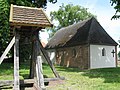
Bandekow village church

Bridge over the Sude near Bandekow


Web links
Individual evidence
- ↑ Statistisches Amt MV - population status of the districts, offices and municipalities 2019 (XLS file) (official population figures in the update of the 2011 census) ( help ).
- ↑ § 1 of the main statute (PDF; 3.4 MB) of the municipality
- ↑ Main Statute, Section 2, Paragraph 3

Alt Krenzlin | Old Zachun | Balow | Bandenitz | Banzkow | Barkhagen | Barnin | Belsch | Bengerstorf | Possession | Blankenberg | Blievenstorf | Bobzin | Boizenburg / Elbe | Borkow | Brahlstorf | Brenz | Bresegard at Eldena | Bresegard near Picher | Bruel | Brunow | Bülow | Cambs | Crivitz | Dabel | Dambeck | Demes | Dersenow | Dobbertin | Dobin at the lake | Dömitz | Domsühl | Dumber | Eldena | Friedrichsruhe | Gallin | Gallin Cupcentess | Gammelin | Ganzlin | Gehlsbach | Gneven | Göhlen | Goldberg | Gorlose | Grabow | Granzin | Grebs-Niendorf | Greetings | Greven | Great Godems | Big stuff | Groß Laasch | Hagenow | Hohen Pritz | Holthusen | Hoort | Hülseburg | Parental leave | Karrenzin | Karstädt | Church of Jesar | Klein Rogahn | Tempzin Monastery | Kobrow | Kogel | Circling | Kremmin | Kritzow | Kuhlen-Wendorf | Cow peat | Langen Brütz | Leezen | Lewitzrand | Luebesse | Lueblow | Lübheen | Luebz | Ludwigslust | Lüttow-Valluhn | Malk Göhren | Malliss | Mestlin | Milow | Möllenbeck | Moraas | Muchow | Mustin | New Gülze | New Kaliss | New Poserin | Neustadt-Glewe | Nostorf | Upper Warnow | Pampow | Parchim | Passow | Pätow-Steegen | Picher | Pinnow | Plate | Plau am See | Prislich | Pritzier | Raben Steinfeld | Rastow | Redefin | Rome | Ruhner Mountains | Lap in | Schwanheide | Siggelkow | Spornitz | Sternberg | Stumble | Stralendorf | Straw churches | Sukow | Sülstorf | Techentin | Teldau | Ticino | Toddin | Tramm | Uelitz | Vellahn | Vielank | Warlitz | Warlow | Warsow | Weitendorf | Werder | Wittenburg | Wittendbod | Wittenförden | Witch | Wöbbelin | Zapel | Zarrentin am Schaalsee | Ziegendorf | Zierzow | Zölkow | Zulow