
Zölkow
| coat of arms | Germany map | |
|---|---|---|

|
Coordinates: 53 ° 34 ' N , 11 ° 49' E |
|
| Basic data | ||
| State : | Mecklenburg-Western Pomerania | |
| County : | Ludwigslust-Parchim | |
| Office : | Parchimer area | |
| Height : | 57 m above sea level NHN | |
| Area : | 38.73 km 2 | |
| Residents: | 746 (Dec. 31, 2019) | |
| Population density : | 19 inhabitants per km 2 | |
| Postal code : | 19374 | |
| Area code : | 038723 | |
| License plate : | LUP, HGN, LBZ, LWL, PCH, STB | |
| Community key : | 13 0 76 162 | |
| Community structure: | 4 districts | |
| Office administration address: | Walter-Hase-Strasse 42 19370 Parchim |
|
| Website : | ||
| Mayor : | Jens-Uwe Springer | |
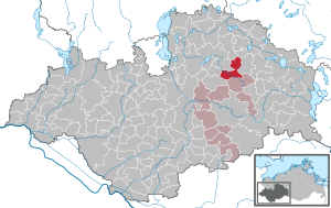
| Location of the municipality of Zölkow in the Ludwigslust-Parchim district | ||
  |
||

Zölkow is a municipality in the Ludwigslust-Parchim district in Mecklenburg-Western Pomerania (Germany). It is administered by the Parchimer Umland Office based in Parchim.
geography
Zölkow is located in a flat area without any outstanding heights. Most of the municipal area through which the Warnow flows is used for agriculture, only in the east there is a smaller forest area. There are no bigger lakes. The community is located 20 kilometers north of Parchim and 12 kilometers west of Crivitz .
Districts of the community are Hof Grabow , Kladrum , Groß Niendorf and Zölkow. The Hohenpritzer settlement and the Ruester settlement also belong to the community.
history
Zölkow was first mentioned in 1328 as Tzollekowe . The place name is derived from the name of the Slavic locator Solek , meaning the place of Solek .
In 1873, Kossebade bought part of the Tannenberg from the community of Zölkow.
On January 1, 1951, the previously independent municipality of Kladrum was incorporated.
On January 1, 2012, Groß Niendorf was incorporated with the districts of Groß Niendorf , Hohenpritzer Siedlung and Ruester Siedlung.
Coat of arms, flag, official seal
The municipality has no officially approved national emblem, neither a coat of arms nor a flag. The official seal is the small state seal with the coat of arms of the state of Mecklenburg. It shows a looking bull's head with a torn off neck fur and crown and the inscription “• GEMEINDE ZÖLKOW • LANDKREIS LUDWIGSLUST-PARCHIM”.
traffic
The federal highway 392 runs through the village . The federal motorway 14 can be reached via the Schwerin-Ost junction (24 km).
Attractions

- Forsthof with forester's house
- Petition
- Kladrum village church and rectory: Gothic stone church from the 13th or 14th century. In the Thirty Years' War destroyed, it was rebuilt in the 17th century and reworked the interior in the 19th century. The tower with its baroque dome , which is rare for Mecklenburg , was given a new roof in the 1990s. The interior of the church was repainted in 2009. The parish also includes the parish villages Bülow and Wessin.
Web links
Individual evidence
- ↑ Statistisches Amt MV - population status of the districts, offices and municipalities 2019 (XLS file) (official population figures in the update of the 2011 census) ( help ).
- ↑ § 1 of the main statute ( memento of January 8, 2016 in the Internet Archive ) (PDF; 2.2 MB) of the municipality
- ^ Paul Kühnel: The Slavic place names in Meklenburg. In: Yearbooks of the Association for Mecklenburg History and Archeology. Vol. 46, 1881, ISSN 0259-7772 , pp. 3-168, here p. 168.
- ↑ § 2 of the territorial change agreement for the merger of the communities of Zölkow and Groß Niendorf (PDF; 22 kB)
- ↑ Main Statute, Section 1, Paragraph 2

Alt Krenzlin | Old Zachun | Balow | Bandenitz | Banzkow | Barkhagen | Barnin | Belsch | Bengerstorf | Possession | Blankenberg | Blievenstorf | Bobzin | Boizenburg / Elbe | Borkow | Brahlstorf | Brenz | Bresegard at Eldena | Bresegard near Picher | Bruel | Brunow | Bülow | Cambs | Crivitz | Dabel | Dambeck | Demes | Dersenow | Dobbertin | Dobin at the lake | Dömitz | Domsühl | Dumber | Eldena | Friedrichsruhe | Gallin | Gallin Cupcentess | Gammelin | Ganzlin | Gehlsbach | Gneven | Göhlen | Goldberg | Gorlose | Grabow | Granzin | Grebs-Niendorf | Greetings | Greven | Great Godems | Big stuff | Groß Laasch | Hagenow | Hohen Pritz | Holthusen | Hoort | Hülseburg | Parental leave | Karrenzin | Karstädt | Church of Jesar | Klein Rogahn | Tempzin Monastery | Kobrow | Kogel | Circling | Kremmin | Kritzow | Kuhlen-Wendorf | Cow peat | Langen Brütz | Leezen | Lewitzrand | Luebesse | Lueblow | Lübheen | Luebz | Ludwigslust | Lüttow-Valluhn | Malk Göhren | Malliss | Mestlin | Milow | Möllenbeck | Moraas | Muchow | Mustin | New Gülze | New Kaliss | New Poserin | Neustadt-Glewe | Nostorf | Upper Warnow | Pampow | Parchim | Passow | Pätow-Steegen | Picher | Pinnow | Plate | Plau am See | Prislich | Pritzier | Raben Steinfeld | Rastow | Redefin | Rome | Ruhner Mountains | Lap in | Schwanheide | Siggelkow | Spornitz | Sternberg | Stumble | Stralendorf | Straw churches | Sukow | Sülstorf | Techentin | Teldau | Ticino | Toddin | Tramm | Uelitz | Vellahn | Vielank | Warlitz | Warlow | Warsow | Weitendorf | Werder | Wittenburg | Wittendbod | Wittenförden | Witch | Wöbbelin | Zapel | Zarrentin am Schaalsee | Ziegendorf | Zierzow | Zölkow | Zulow