
Kogel
| coat of arms | Germany map | |
|---|---|---|

|
Coordinates: 53 ° 30 ' N , 10 ° 57' E |
|
| Basic data | ||
| State : | Mecklenburg-Western Pomerania | |
| County : | Ludwigslust-Parchim | |
| Office : | Zarrentin | |
| Height : | 34 m above sea level NHN | |
| Area : | 29.9 km 2 | |
| Residents: | 676 (Dec. 31, 2019) | |
| Population density : | 23 inhabitants per km 2 | |
| Postal code : | 19246 | |
| Primaries : | 038843, 038851 | |
| License plate : | LUP, HGN, LBZ, LWL, PCH, STB | |
| Community key : | 13 0 76 073 | |
| Community structure: | 7 districts | |
| Office administration address: | Amtsstr. 4-5 19246 Zarrentin |
|
| Website : | ||
| Mayor : | André Brosch | |
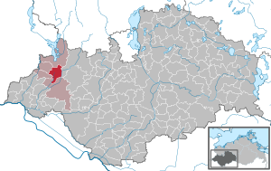
| Location of the municipality of Kogel in the Ludwigslust-Parchim district | ||
  |
||

Kogel is a municipality in the Ludwigslust-Parchim district in Mecklenburg-Western Pomerania (Germany). The community is administered by the Zarrentin Office , based in the town of Zarrentin am Schaalsee . It includes the districts of Kogel, Flugzeughof, Holzkrug and Vietow, the independent communities of Kölzin, Krohnshof and Pamprin, which were independent until the end of 1972, as well as the Schaalmühle settlement.
geography
Kogel is located about 6.5 kilometers southeast of Zarrentin am Schaalsee and the Schaalsee biosphere reserve . The federal motorway 24 crosses the municipality and is accessible via the Zarrentin junction. The Schaale flows south to the Sude .
history
Kogel was first mentioned in a document in the Ratzeburg tithe register in 1230 under his then name Cowale . The place belonged to the parish Camin in the country Wittenburg. The Schaale river , which was made navigable in the 16th century, was one of the livelihoods of the residents . The place is still dominated by agriculture and forestry today.
The first documentary mention of the district of Kölzin can be found in Isfried's partition contract from 1194. Under the name Culsin at the time , it was a donation of the Ratzeburg cathedral chapter and belonged to the parish of Zarrentin since 1230. In the 15th century there was a fulling mill in the place , which was used to process cloth. However, when the shell was made navigable, it was converted into a customs house.
The Pamprin district appears under the name Pampurine for the first time in 1230 in the Ratzeburg tithe register .
politics
Coat of arms, flag, official seal
The municipality has no officially approved national emblem, neither a coat of arms nor a flag. The official seal is the small state seal with the coat of arms of the state of Mecklenburg. It shows a looking bull's head with torn off neck fur and crown and the inscription GEMEINDE KOGEL .
Attractions

Personalities associated with Kogel
- Karl Löwith (1897–1973), worked in 1923 as private tutor for August Freiherr von Flotow in Kogel
- Jörn-Ulrich Bachmann (1925–1989), senior district director in the Soltau district, born on Gut Kronshof
Web links
Individual evidence
- ↑ Statistisches Amt MV - population status of the districts, offices and municipalities 2019 (XLS file) (official population figures in the update of the 2011 census) ( help ).
- ↑ § 1 of the main statute (PDF; 38 kB) of the municipality
- ↑ Main Statute, Section 1, Paragraph 3

Alt Krenzlin | Old Zachun | Balow | Bandenitz | Banzkow | Barkhagen | Barnin | Belsch | Bengerstorf | Possession | Blankenberg | Blievenstorf | Bobzin | Boizenburg / Elbe | Borkow | Brahlstorf | Brenz | Bresegard at Eldena | Bresegard near Picher | Bruel | Brunow | Bülow | Cambs | Crivitz | Dabel | Dambeck | Demes | Dersenow | Dobbertin | Dobin at the lake | Dömitz | Domsühl | Dumber | Eldena | Friedrichsruhe | Gallin | Gallin Cupcentess | Gammelin | Ganzlin | Gehlsbach | Gneven | Göhlen | Goldberg | Gorlose | Grabow | Granzin | Grebs-Niendorf | Greetings | Greven | Great Godems | Big stuff | Groß Laasch | Hagenow | Hohen Pritz | Holthusen | Hoort | Hülseburg | Parental leave | Karrenzin | Karstädt | Church of Jesar | Klein Rogahn | Tempzin Monastery | Kobrow | Kogel | Circling | Kremmin | Kritzow | Kuhlen-Wendorf | Cow peat | Langen Brütz | Leezen | Lewitzrand | Luebesse | Lueblow | Lübheen | Luebz | Ludwigslust | Lüttow-Valluhn | Malk Göhren | Malliss | Mestlin | Milow | Möllenbeck | Moraas | Muchow | Mustin | New Gülze | New Kaliss | New Poserin | Neustadt-Glewe | Nostorf | Upper Warnow | Pampow | Parchim | Passow | Pätow-Steegen | Picher | Pinnow | Plate | Plau am See | Prislich | Pritzier | Raben Steinfeld | Rastow | Redefin | Rome | Ruhner Mountains | Lap in | Schwanheide | Siggelkow | Spornitz | Sternberg | Stumble | Stralendorf | Straw churches | Sukow | Sülstorf | Techentin | Teldau | Ticino | Toddin | Tramm | Uelitz | Vellahn | Vielank | Warlitz | Warlow | Warsow | Weitendorf | Werder | Wittenburg | Wittendbod | Wittenförden | Witch | Wöbbelin | Zapel | Zarrentin am Schaalsee | Ziegendorf | Zierzow | Zölkow | Zulow