
Zarrentin at the Schaalsee
| coat of arms | Germany map | |
|---|---|---|

|
Coordinates: 53 ° 33 ' N , 10 ° 55' E |
|
| Basic data | ||
| State : | Mecklenburg-Western Pomerania | |
| County : | Ludwigslust-Parchim | |
| Office : | Zarrentin | |
| Height : | 40 m above sea level NHN | |
| Area : | 91.88 km 2 | |
| Residents: | 5228 (Dec. 31, 2019) | |
| Population density : | 57 inhabitants per km 2 | |
| Postal code : | 19246 | |
| Area code : | 038851 | |
| License plate : | LUP, HGN, LBZ, LWL, PCH, STB | |
| Community key : | 13 0 76 159 | |
| City structure: | 7 districts | |
City administration address : |
Kirchplatz 8 in 19246 Zarrentin am Schaalsee |
|
| Website : | ||
| Mayor : | Klaus Draeger | |
| Location of the town of Zarrentin am Schaalsee in the Ludwigslust-Parchim district | ||
  |
||

Zarrentin am Schaalsee (until 2004: Zarrentin ) is a town in the Ludwigslust-Parchim district in Mecklenburg-Western Pomerania (Germany). It is the seat of the Zarrentin Office , to which four other municipalities belong. The city is part of the Hamburg metropolitan region and is also a basic center for its surroundings .
geography
Geographical location
The city is located in the west of Mecklenburg-Western Pomerania on the border with Schleswig-Holstein, about 50 kilometers east of Hamburg and 30 kilometers west of Schwerin. The core city is located on the south bank of the heavily structured Schaalsee , which is part of the biosphere reserve of the same name . The shell that flows through the urban area forms the natural drainage of the lake. Other bodies of water in the area include the Hammerbach, the Boize , the Kleine Schaale , the Neuenkirchener See and the Boissower See . Several stretches of land and bodies of water are designated as nature reserves.
Zarrentin is located directly south of the maximum ice advance of the Vistula Ice Age (Frankfurt Stadium) in a sand area , the northern districts are in the terminal moraine ranges . The majority of the land is farmed. Occasionally, especially on the banks of the Schaalsee, there are forests.
City structure
The following districts belong to the city of Zarrentin am Schaalsee:
|
||
history
Surname
The place was first mentioned in 1194 as "Zarnethin". The name is derived from the Old Slavic word "črŭnŭ" and means something like "place of the black".
middle Ages


After the subjugation of the Slavs, Zarrentin came under the rule of Count Heinrich von Badewide around 1139/1143 . German farmers - mostly from neighboring areas to the west - settled here. The place was first mentioned in 1194 as a German parish village, with a Romanesque stone church in the diocese of Ratzeburg . The place and church of Zarrentin are also mentioned in 1230 in the Ratzeburg tithe register , which lists the localities that belonged to the diocese of Ratzeburg at that time, sorted according to parishes . After the Battle of Bornhöved (1227) the place came to the County of Schwerin and in 1359 to the Duchy of Mecklenburg .


The Cistercian convent was founded around 1250 and was first named in a document in 1251. On May 19, 1252, Bishop Friedrich von Ratzeburg confirmed the foundation of the monastery. The parish church became a monastery church. In 1460, the current Gothic nave was built using parts of the old church with drainage means . 1552 was on the orders of the Duke Johann Albrecht I. The nuns monastery secularized . After 1576 the dilapidated south and west wings were torn down; the east wing from the 14th century was preserved. Now the office of Zarrentin, to which twelve other places belonged, was administered by officials of the duchy. Due to financial difficulties, the office was pledged to Hanover by the Duke from 1569 to 1766, and then again from 1734 to 1766 .
From 1600
During the Thirty Years War , Zarrentin was also looted, pillaged and murdered by imperial or Swedish troops. Few residents survived in poverty. In 1672 the church was renovated and the west tower completed. In 1695, 1729 and 1775 the place burned down almost completely.
During the war of liberation on September 18, 1813, there was a heavy battle in the city between French-Danish troops and the Lützow Freikorps .
In 1834 the offices of Zarrentin and Wittenburg were merged . In 1875 the first elected council met.
The original street village expanded in the 19th century. In the sexton school next to the rectory was taught. In 1896 it was connected to the Hagenow Land – Bad Oldesloe railway line . Now a barrel factory, a potato flake factory, a lime distillery, building contractors, grain and cattle dealers have settled here. The gas works was built and Zarrentin grew considerably. On April 1, 1938 - with a population of 2,000 - Zarrentin received town charter . Since then it has also developed into an excursion and vacation spot.
After the Second World War , Zarrentin became an isolated border town in a controlled border district of the GDR . Even access to the neighboring Schaalsee was denied. During this time, the central water supply was installed, a new school was built, the kindergarten was built and the road conditions improved. However, the monastery building continued to deteriorate.
From 1952 to 1994 Zarrentin belonged to the Hagenow district (until 1990 in the GDR district of Schwerin , 1990–1994 in the state of Mecklenburg-Western Pomerania ). In 1994 the city was incorporated into the Ludwigslust district. Since June 13, 2004, the city has had the official name Zarrentin am Schaalsee . Since the district reform in 2011 , it has been in the Ludwigslust-Parchim district .
In November 1982 the Hamburg - Berlin transit highway was completed. A large border crossing was built at the gates of Zarrentin . After the reunification, the facilities were dismantled. Since then there has been a motorway service station and a large commercial area on the site. After the fall of the Wall , the city was thoroughly redeveloped from 1991 with the help of urban development funding. The dilapidated monastery building could be saved and is now used by the city administration and as a library, as well as for concerts, exhibitions and other cultural uses.
A 260-hectare industrial park on the A 24 has created more than 1,500 jobs. The city was connected to a long-distance gas network and a central waste water supply. “Soft” tourism also experienced a significant upswing. In 2000 the Schaalsee biosphere reserve on the border with Schleswig-Holstein was designated as a biosphere reserve.
History of the districts
Lassahn was first mentioned in a document in 1230 in the Ratzeburg tithe register. The Wendish name Lassahn refers to forest dwellers . The St. Abundus Church already exists around 1230. For more see Lassahn # history .
Stintenburginsel was owned by the County of Schwerin in the 13th century . Landowners were then u. a. the families Herzog von Lauenburg (1642–1680), von Lützow , von Bülow , von Hammerstein (until 1740) and von Bernstorff (until 1944 and from 1993). The manor house dates from 1817. For more see Stintenburginsel # history .
Incorporations
Boize has been part of Zarrentin since January 1st, 1957. Testorf was added on January 1, 1974. On June 13, 2004, the communities of Bantin, Lassahn and Neuhof were incorporated into the city of Zarrentin. At the same time the city name was changed to Zarrentin am Schaalsee .
Population development
|
|
Status: December 31 of the respective year
The strong population increase in 2005 is due to the incorporation of three places in 2004.
politics
City council
The city council of the city of Zarrentin am Schaalsee has consisted of 16 members since the local elections on May 26, 2019.
| Party / list | Seats |
|---|---|
| Close to the citizen for close to the citizen | 9 |
| CDU | 3 |
| SPD | 2 |
| The left | 1 |
| Individual applicant Dietlinde Böpple | 1 |
mayor
- 1972-2014: Greta Glass
- since 2014: Klaus Draeger (voter group close to the citizens for closeness to the citizen)
Draeger was elected in the mayoral election on May 26, 2019 with 87.0 percent of the valid votes for a further term of five years.
coat of arms
|
|
Blazon : “Divided; above in blue two silver fish one above the other; below in red a straight golden abbess's staff. "
The coat of arms was designed by Otto Menzel from Schwerin according to a proposal submitted by the Schwerin Secret and Main Archives . It was approved by the Mecklenburg-Schwerin State Ministry on May 13, 1922 and registered under the number 51 of the coat of arms of the state of Mecklenburg-Western Pomerania. |
| Reasons for the coat of arms: In the coat of arms, the two fish on a blue background are supposed to refer to the location of the place on the Schaalsee on the one hand and to the vendace occurring in this lake on the other, a species of fish that can only be found in a few particularly deep waters. There is a legend about the presence of vendace in the Schaalsee. According to this, an abbess of the Zarrentin monastery is said to have once promised the devil her soul if he would bring her a few whitefish by midnight. Tormented by remorse, she finally confessed. A nun assured her of help and put the church clock forward an hour. Just as the devil was over the Schaalsee, the hour struck midnight. Full of horror at his delay and anger at the lost soul, he let the whitefish he had brought with him fall into the water. They have been populating the lake ever since. The abbess's staff should remind of the former nunnery. The colors blue, gold and red reflect the Mecklenburg colors. |
flag
The city does not have an officially approved flag .
Official seal
The official seal shows the city coat of arms with the inscription “STADT ZARRENTIN AM SCHAALSEE”.
Sights and culture


Buildings
The small town of Zarrentin - one of the oldest places in the region - is worth seeing as a whole because of its small-town, almost village-like character and its idyllic location on the Schaalsee with its promenade.
- Zarrentin Monastery , founded in 1248 and dissolved in 1552. The preserved east wing was extensively renovated and is now used for cultural exhibitions, concerts and events. The building houses a permanent exhibition on the monastery and its history in the cloister.
- Church Zarrentin ( field stone and brick church ), village church in the first half of the 13th century, then parish and monastery church from around 1250 to 1552 and then again only parish church. Today's Gothic nave was built in 1460 . The west tower was completed in 1672. The Romanesque stone masonry of the choir dates from the 1230s / 40s. Around 1300/10 the choir was raised with brickwork. The nave and the tower contain parts from the 13th and 14th centuries. The pulpit from 1533/34 from the workshop of the carver Benedikt Dreyer was acquired in 1699 from the Marienkirche in Lübeck .
- Local history museum, founded in 1988 by a citizens' initiative, since 2000 in the restored former official barn, today's monastery barn on the church square. The documentation and collections contain a variety of information on the city and regional history.
- Town hall (listed) with its half-timbered part ( brick building with neo-Gothic gables)
- Pahlhuus, information center of the Schaalsee biosphere reserve
- St. Abundus Church in Lassahn with field stone sacristy from the 13th century, received in the 17th / 18th century. Century half-timbered buildings and a tower. The interior decoration includes an altarpiece from 1898. On the top of the tower there is a golden cock from 1980, in the tower a bell from 1993. Two disused bells are displayed in front of the church.
nature
- Schaalsee biosphere reserve, 309 km², recognized by UNESCO as an international UNESCO biosphere reserve in 2000 . The west side of the Schaalsee was placed under protection as the Lauenburg Lakes Nature Park as early as 1960 .
Impressions

Zarrentin city coat of arms at the town hall

Monastery church, west view

Monastery church, church interior
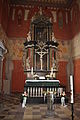
Monastery church, altar

Monastery church, organ loft

Zarrentin Monastery, cloister
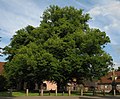
Linden tree at the monastery (natural monument)

Boissow, old forge

Boissower See nature reserve


Regular events
- Theater im Pahlhuus (puppet theater for children; every 1st Wednesday between February and December)
- Biosphere Schaalsee Market (every 1st Sunday from April to November)
- Station Festival (2nd weekend in May)
- Neptune Festival (1st weekend in July)
- Schützenfest (2nd weekend in August)
- Apple Day (October)
- Monastery / Christmas market (2nd Advent)
Economy and Infrastructure

traffic
The federal highway 195 begins in Zarrentin and leads south via Boizenburg / Elbe and Dömitz to Wittenberge . You can use it to get to the Zarrentin junction on the Autobahn 24 Berlin – Hamburg.
Zarrentin has no rail connection. The city had been on the Hagenow Land – Bad Oldesloe railway line since 1896 , the so-called Kaiserbahn , which connected Hagenow with Bad Oldesloe until the end of World War II . With the division of Germany and the dismantling of the cross-border tracks, Zarrentin became a terminus on the GDR side. In 2000 the regular passenger traffic was discontinued. Between 2008 and 2010, the West Mecklenburg Railway Company (WEMEG) once again ran two pairs of trains with rail buses under the Schaalsee-Express brand between Hagenow Land and Zarrentin every first Sunday of the month .
Public facilities
- Elementary school in Zarrentin (sponsor: Zarrentin-Lassahn School Association)
- Children's and youth facilities
- Library
Personalities
sons and daughters of the town
- Marianne von Rantzau (1811–1855), deaconess , born in Testorf
- Otto Mantzel (1882–1968), sculptor
- Joachim Seeländer (* 1924), politician (LDPD)
- Günter Warnecke (* 1937), professor of production engineering and machine tools
Personalities associated with Zarrentin
- Otto Karsten (1899–1967), politician (CDU), city councilor in Zarrentin
- Ferdinand Schmidt (1909–1981), 1945 to 1975 pharmacist and 1946 founder of a pharmaceutical-historical library in Zarrentin
Individual evidence
- ↑ Statistisches Amt MV - population status of the districts, offices and municipalities 2019 (XLS file) (official population figures in the update of the 2011 census) ( help ).
- ^ Regional Spatial Development Program West Mecklenburg (2011) , Regional Planning Association, accessed on July 12, 2015
- ↑ Main statute of the city of Zarrentin am Schaalsee, § 9
- ^ Paul Kühnel: The Slavic place names in Meklenburg . In: Yearbooks of the Association for Meklenburg History and Antiquity . Yearbooks of history. tape 46 , 1881, ISSN 0259-7772 , p. 165 ( online [accessed June 14, 2019]).
- ^ Friedrich Schlie: Art and historical monuments of the Grand Duchy of Mecklenburg. P. 98, Schwerin 1899
- ↑ a b Municipalities 1994 and their changes since January 1st, 1948 in the new federal states , Metzler-Poeschel publishing house, Stuttgart, 1995, ISBN 3-8246-0321-7 , publisher: Federal Statistical Office
- ^ StBA: Changes in the municipalities in Germany, see 2004
- ↑ Population development of the districts and municipalities in Mecklenburg-Western Pomerania (Statistical Report AI of the Statistical Office Mecklenburg-Western Pomerania)
- ↑ Local elections on May 26, 2019
- ^ Petra Burghardt: Stories from over there. P. 37/38.
- ↑ Zarrentin: Kiss to win the election. In: Schweriner Volkszeitung , May 26, 2014
- ↑ Mayoral election on May 26, 2019
- ↑ Hans-Heinz Schütt: On shield and flag - the coats of arms and flags of the state of Mecklenburg-Western Pomerania and its municipalities . Ed .: production office TINUS; Schwerin. 2011, ISBN 978-3-9814380-0-0 , pp. 152 .
- ↑ a b main statute § 1 (PDF).
- ↑ News in brief. WEMEG gives up trips on the Schaalsee-Express. lokrundschau.de, February 15, 2011, accessed on January 4, 2015 .
Web links
- ( Page no longer available , search in web archives: Zarrentiner web portal for history )
- Picture gallery of the former Zarrentin border crossing

Alt Krenzlin | Old Zachun | Balow | Bandenitz | Banzkow | Barkhagen | Barnin | Belsch | Bengerstorf | Possession | Blankenberg | Blievenstorf | Bobzin | Boizenburg / Elbe | Borkow | Brahlstorf | Brenz | Bresegard at Eldena | Bresegard near Picher | Bruel | Brunow | Bülow | Cambs | Crivitz | Dabel | Dambeck | Demes | Dersenow | Dobbertin | Dobin at the lake | Dömitz | Domsühl | Dumber | Eldena | Friedrichsruhe | Gallin | Gallin Cupcentess | Gammelin | Ganzlin | Gehlsbach | Gneven | Göhlen | Goldberg | Gorlose | Grabow | Granzin | Grebs-Niendorf | Greetings | Greven | Great Godems | Big stuff | Groß Laasch | Hagenow | Hohen Pritz | Holthusen | Hoort | Hülseburg | Parental leave | Karrenzin | Karstädt | Church of Jesar | Klein Rogahn | Tempzin Monastery | Kobrow | Kogel | Circling | Kremmin | Kritzow | Kuhlen-Wendorf | Cow peat | Langen Brütz | Leezen | Lewitzrand | Luebesse | Lueblow | Lübheen | Luebz | Ludwigslust | Lüttow-Valluhn | Malk Göhren | Malliss | Mestlin | Milow | Möllenbeck | Moraas | Muchow | Mustin | New Gülze | New Kaliss | New Poserin | Neustadt-Glewe | Nostorf | Upper Warnow | Pampow | Parchim | Passow | Pätow-Steegen | Picher | Pinnow | Plate | Plau am See | Prislich | Pritzier | Raben Steinfeld | Rastow | Redefin | Rome | Ruhner Mountains | Lap in | Schwanheide | Siggelkow | Spornitz | Sternberg | Stumble | Stralendorf | Straw churches | Sukow | Sülstorf | Techentin | Teldau | Ticino | Toddin | Tramm | Uelitz | Vellahn | Vielank | Warlitz | Warlow | Warsow | Weitendorf | Werder | Wittenburg | Wittendbod | Wittenförden | Witch | Wöbbelin | Zapel | Zarrentin am Schaalsee | Ziegendorf | Zierzow | Zölkow | Zulow