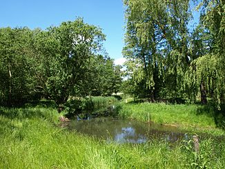
Boize
| Boize | ||
|
Boize at the level of Schwartow |
||
| Data | ||
| Water code | DE : 593694 | |
| location | Schleswig-Holstein, West Mecklenburg | |
| River system | Elbe | |
| Drain over | Sude → Elbe → North Sea | |
| source | West of the Schaalsee near Seedorf 53 ° 37 ′ 31 ″ N , 10 ° 50 ′ 52 ″ E |
|
| Source height | approx. 40 m above sea level NN | |
| muzzle | At Boizenburg / Elbe in the Sude coordinates: 53 ° 22 '25 " N , 10 ° 41' 50" E 53 ° 22 '25 " N , 10 ° 41' 50" E |
|
| Mouth height | 5 m above sea level NN | |
| Height difference | approx. 35 m | |
| Bottom slope | approx. 1.2 ‰ | |
| length | 30 km | |
| Catchment area | 204 km² | |
| Discharge at the Schwartow A Eo gauge : 157 km² Location: 5 km above the mouth |
NNQ (often September 1973) MNQ 1976–2013 MQ 1976–2013 Mq 1976–2013 MHQ 1976–2013 HHQ (March 12, 1981) |
6 l / s 333 l / s 1.22 m³ / s 7.8 l / (s km²) 5.22 m³ / s 8.3 m³ / s |
| Drain |
MQ |
1.6 m³ / s |
| Left tributaries | Gudower Grenzgraben | |
| Right tributaries | Waldmoorbach | |
| Small towns | Boizenburg / Elbe | |
The Boize is a 30 km long right tributary of the Sude in northern Germany.
The river rises west of the Schaalsee and the Seedorfer Küchensee in the east of Schleswig-Holstein near the town of Seedorf at an altitude of about 40 m above sea level. NHN in a forest called Birkenort . From here on, the Boize initially runs very curvy in a southerly direction until it forms the border between Schleswig-Holstein and Mecklenburg-Western Pomerania on a section east of Gudow .
In Mecklenburg territory, the largely straightened Boize crosses under Lüttow-Valluhn under the federal motorway 24 and from here runs parallel to the federal highway 195 . In Boizenburg / Elbe, the Boize feeds a ring-shaped ditch system around the city center with ramparts. The last meters of the river are developed as a port facility, where the old Elbe shipyard in Boizenburg was also located. Here at the northern tip of the Elbe-Mecklenburg-Vorpommern River Landscape Biosphere Reserve , the Boize flows into the Sude, which even after a few meters flows into the Elbe on the right .
The mouth of the Sude was relocated from Gothmann to the Boizenburg harbor entrance around 1983, so that the Boize became the tributary of the Sude. Before that, the Boize flowed directly into the Elbe.
The source of the Boize is located south of the North Sea-Baltic watershed , because while the water reaches the North Sea via the Sude and Elbe, the Ratzeburg Lake , located just a few kilometers north of the source, drains via the Wakenitz into the Baltic Sea. Tributaries of the Boize include the Klein-Zecher border ditch, the Gudower border ditch, the Waldmoorbach, the Färbergraben and numerous drainage ditches.
The action alliance Pro Boize advocates gentle water maintenance, renaturation and the dismantling of weirs in order to enable fish to climb and improve the ecological status of the water.
In 2010, the Boize between Autobahn 24 and Greven was ecologically renovated by the Boize-Schaale-Sude Water and Soil Association with EU funds.
In February 2014, the heavy weeds in the Boize at the level of the industrial area on Autobahn 24 were removed.
Fish ladder at the Gresse weir Figure 1
Fish ladder at the Gresse weir picture 2
the brew unites with the boize
Web links
Individual evidence
- ^ German Hydrological Yearbook Elbe Region, Part III 2013. (PDF) ISSN 0949-3654. Free and Hanseatic City of Hamburg, Hamburg Port Authority, p. 143 , accessed on October 4, 2017 (German, at: dgj.de).
- ↑ Boizenburg Anglers' Association - flowing waters
- ↑ Michael Bergemann: Complete list of flowing waters in the Elbe catchment area . Authority for Environment and Energy, Hamburg July 1, 2015 ( PDF; 802 kB [accessed on November 29, 2015]).
- ^ Action alliance Pro Boize
- ↑ SVZ press article "Hereditary: Boize on A24 renovated"


