
Brew


The Sude is an 85 kilometers long, right (eastern) tributary of the Elbe in Mecklenburg-Western Pomerania and Lower Saxony .
River course
The Sude rises in a forest near the Black Moor between Renzow and Groß Welzin, from there to cross the Dümmersee to the east . The water then flows away in a southerly direction. In the vicinity of Bandenitz it passes under the federal highway 24 . It flows past Hagenow to the east. After that, the river runs in a long right curve to the west, past Lübenheen and crosses the Lower Saxony municipality of Amt Neuhaus . Finally, the Sude flows west of Boizenburg / Elbe at Elbe river kilometer 559.52 into the Elbe, which is the border river to Lower Saxony in this area.
From 1842 onwards, after being extended, the Sude flowed into the Elbe at 557 km near Gothmann. The course was moved to the Boizenburg harbor around 1983, so that the Boize became a tributary of the Sude.

Sude upper reaches before reaching the Dümmersee

Brew at Radelübbe
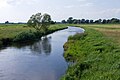
Sude near Preten (Lower Saxony Office Neuhaus)


Watershed
The source area of the Sude lies on the North Sea-Baltic Sea watershed . While the Sude drains in a south-westerly direction over the Elbe into the North Sea, the water of the Stepenitz , which rises just a few kilometers to the north-east and flows in a north-westerly direction, reaches the Baltic Sea over the Trave .
Wildlife
The brew has a very good stock of fish, especially the pike is very common, but does not grow to impressive sizes due to high fishing. In addition, all white fish species are found, even the barbel has been successfully reintroduced. The eel and the eel burbot , which is the largest spawning predator in the river, are occasionally caught by anglers.
There are also beavers and water rats and an intact animal world with various wild animals around the brewery. The Stork Foundation has bought large areas of the Neuhaus district. Among other things, these are used to breed rare farm animal breeds.
tourism
The brew is made accessible to tourists, for example by hiking in the water. In Gößlow there is a newly built log house, which can be used as a starting point or rest area. Several weirs have to be crossed. In addition, guided Sudetours are offered.
In Sückau , near the confluence of the Rögnitz and between Sückau and Preten, there are wooden observation towers that offer the opportunity to look over spacious areas. They were built by the Stork Foundation.
Attractions
In addition to many listed buildings along the Sude, such as B. the wooden weir at the old mill in Brömsenberg, there is the historic railway bridge in Preten , which can be used by cyclists today.
Weirs, river slides and river structures
There are weirs and Sohlgleiten in Radelübbe , Kuhstorf , Redefin , Brömsenberg , Langenheide and Gothmann .
From Preten to Boizenburg , the brew is lined with some flood polders , some of which are separated by pumping stations . They serve to accommodate flood peaks. There are also protective polders that are supposed to protect the localities. If the water level difference at the weir in Gothmann is more than 1.5 meters, it must be closed for structural safety reasons. After that, the water from the brew can no longer drain away and builds up. Thanks to the existing retreat areas, there was no major damage to the neighboring towns during the Elbe floods in 2002.
In the meantime, fish ladders have been installed in Boizenburg, Brömsenberg and Redefin to create migration opportunities for fish.
politics
In the Neuhaus district, especially in and around Sückau, there is a citizens' initiative that advocates a continuation of the dike expansion.
Web links
Individual evidence
- ↑ a b c Sude, Aland and Havel - fish population studies and pollution of bream, eel and pikeperch in the lower reaches of the Elbe tributaries (PDF; 2.47 MB) Working group for keeping the Elbe clean, June 2001, fgg-elbe.de
- ^ German Hydrological Yearbook Elbe Region, Part III 2013. (PDF) ISSN 0949-3654. Free and Hanseatic City of Hamburg, Hamburg Port Authority, p. 140 , accessed on October 4, 2017 (German, at: dgj.de).
- ↑ Michael Bergemann: Complete list of flowing waters in the Elbe catchment area . Authority for the Environment and Energy, Hamburg July 1, 2015 ( fgg-elbe.de [PDF; 802 kB ; accessed on November 29, 2015]).