
Circling
| coat of arms | Germany map | |
|---|---|---|

|
Coordinates: 53 ° 24 ' N , 12 ° 3' E |
|
| Basic data | ||
| State : | Mecklenburg-Western Pomerania | |
| County : | Ludwigslust-Parchim | |
| Office : | Eldenburg Luebz | |
| Height : | 65 m above sea level NHN | |
| Area : | 24.83 km 2 | |
| Residents: | 363 (Dec. 31, 2019) | |
| Population density : | 15 inhabitants per km 2 | |
| Postal code : | 19386 | |
| Area code : | 038733 | |
| License plate : | LUP, HGN, LBZ, LWL, PCH, STB | |
| Community key : | 13 0 76 075 | |
| Community structure: | 5 districts | |
| Office administration address: | Am Markt 22 19386 Lübz |
|
| Website : | ||
| Mayor : | Alexander Leetz | |
| Location of the municipality of Kreien in the Ludwigslust-Parchim district | ||
  |
||

Kreien is a municipality in the east of the Ludwigslust-Parchim district in Mecklenburg-Western Pomerania (Germany). It is administered by the Amt Eldenburg Lübz , based in the city of Lübz .
Geography and traffic
The community is located about six kilometers south of Lübz , in the lowlands east of the Müritz-Elde waterway and north of the Gehlsbach . The valley of the stream is under nature protection. To the north of the valley is the Wilsener Tannen forest . The highest point in the municipality is the Black Mountain at 89.3 m above sea level. NHN in the Kreiener Tannen forest area in the northwest of the municipality. In the north is the Kreiener Holz forest area . The only lake worth mentioning is the Dorfsee near Kreien.
Districts
- Court circles
- Colony circles
- Circling
- Circle expansion
- Wilsen
history
The municipality was already settled in the Neolithic , as can be seen from archaeological finds.
Kreien was first mentioned in a document in 1271. The place name comes from the Old Slavic kraj for land and means rural place .
Wilsen was first mentioned in a document as Wilssne in 1293. The place name probably comes from the Old Slavic vlŭg for humid and means humid place .
The district Wilsener Mühle was incorporated into the municipal area in 1939 with the 8th implementation ordinance for the law on Greater Hamburg and other land consolidations ; she had previously belonged to Jännersdorf .
On July 1, 1950, the previously independent municipalities Hof Kreien (also Kreien, Hof) and Wilsen were incorporated.
politics
Coat of arms, flag, official seal
The municipality has no officially approved national emblem, neither a coat of arms nor a flag. The official seal is the small state seal with the coat of arms of the state of Mecklenburg. It shows a looking bull's head with torn off neck fur and crown and the inscription "GEMEINDE KREIEN".
Attractions
- Hof Kreien manor from the 18th century
- Village church in Kreien
- Rectory Kreien
- Wilsen Chapel
- Dealings
- Barrows
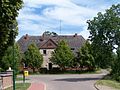
Manor house in Hof Kreien

Rectory Kreien

Village church in Kreien

Chapel in Wilsen


Web links
- Circling on the official pages
Individual evidence
- ↑ Statistisches Amt MV - population status of the districts, offices and municipalities 2019 (XLS file) (official population figures in the update of the 2011 census) ( help ).
- ↑ § 2 of the main statute (PDF; 19 kB) of the municipality
- ^ The Slavic place names in Meklenburg in the year books of the Association for Mecklenburg History and Archeology . - Vol. 46 (1881), p. 76, digitized on mvdok.lbmv.de
- ^ The Slavic place names in Meklenburg in the year books of the Association for Mecklenburg History and Archeology . - Vol. 46 (1881), p. 158
- ↑ 8. Implementing ordinance for the law on Greater Hamburg and other territorial consolidations , Article II .: Incorporation of the Wilsener Mühle district into the state of Mecklenburg
- ↑ main statute § 1

Alt Krenzlin | Old Zachun | Balow | Bandenitz | Banzkow | Barkhagen | Barnin | Belsch | Bengerstorf | Possession | Blankenberg | Blievenstorf | Bobzin | Boizenburg / Elbe | Borkow | Brahlstorf | Brenz | Bresegard at Eldena | Bresegard near Picher | Bruel | Brunow | Bülow | Cambs | Crivitz | Dabel | Dambeck | Demes | Dersenow | Dobbertin | Dobin at the lake | Dömitz | Domsühl | Dumber | Eldena | Friedrichsruhe | Gallin | Gallin Cupcentess | Gammelin | Ganzlin | Gehlsbach | Gneven | Göhlen | Goldberg | Gorlose | Grabow | Granzin | Grebs-Niendorf | Greetings | Greven | Great Godems | Big stuff | Groß Laasch | Hagenow | Hohen Pritz | Holthusen | Hoort | Hülseburg | Parental leave | Karrenzin | Karstädt | Church of Jesar | Klein Rogahn | Tempzin Monastery | Kobrow | Kogel | Circling | Kremmin | Kritzow | Kuhlen-Wendorf | Cow peat | Langen Brütz | Leezen | Lewitzrand | Luebesse | Lueblow | Lübheen | Luebz | Ludwigslust | Lüttow-Valluhn | Malk Göhren | Malliss | Mestlin | Milow | Möllenbeck | Moraas | Muchow | Mustin | New Gülze | New Kaliss | New Poserin | Neustadt-Glewe | Nostorf | Upper Warnow | Pampow | Parchim | Passow | Pätow-Steegen | Picher | Pinnow | Plate | Plau am See | Prislich | Pritzier | Raben Steinfeld | Rastow | Redefin | Rome | Ruhner Mountains | Lap in | Schwanheide | Siggelkow | Spornitz | Sternberg | Stumble | Stralendorf | Straw churches | Sukow | Sülstorf | Techentin | Teldau | Ticino | Toddin | Tramm | Uelitz | Vellahn | Vielank | Warlitz | Warlow | Warsow | Weitendorf | Werder | Wittenburg | Wittendbod | Wittenförden | Witch | Wöbbelin | Zapel | Zarrentin am Schaalsee | Ziegendorf | Zierzow | Zölkow | Zulow