
Elde

The Elde is the longest river in Mecklenburg-Western Pomerania , lies in the south and southwest of this country and connects the area around the Müritz with the Elbe . In its upper course it flows through several large lakes in the Mecklenburg Lake District . The last of these lakes is the Plauer See , from which the river is blocked . 180 kilometers of the altogether 208 kilometers long Elde from the southern edge of the Müritz to the Elbe near Dömitz are navigable. They form as a federal waterway designated Müritz-Elde waterway .
River course
source

The source of the Elde is located in the Altenhofer district of Darze , six kilometers southeast of the Plauer See and 20 kilometers west of the Müritz. The first about 600 meters of the source stream flow in a pipe laid under a field, from which it flows almost 400 meters west of Darze at a terrain height of about 90 m above sea level. NHN emerges.
In some documents other sources are mentioned. The maps of the Office for Geoinformation, Surveying and Cadastre at the State Office for Internal Administration in Mecklenburg-Western Pomerania point to a ditch that rises near the Fincken district of Knüppeldamm. In 1997, the State Office for the Environment, Nature Conservation and Geology Mecklenburg-Western Pomerania (LUNG) named further source locations in the descriptions of two biotopes in the vicinity (northeast of Knüppeldamm and in the Darzer Tannen north of the federal highway 198), but decided on the Darzer source.
The source of the Elde near Darze is also localized in old written texts ("near the Darzer Mühle")
The Dosse, which flows southeast, and the Stepenitz, which flows southwest, arise only a few kilometers southwest of the Elde spring .
Upper reaches and the Great Lakes area

The Elde initially flows to the southeast. From the source to the Müritzsee it runs through a flat, formerly swampy area. It is mostly straightened and accompanied by numerous drainage and spring ditches. Its upper course is a large, counter-clockwise arch, encompassing about three quarters of a circle and reaching as far as Plau. While the Eldequelle rises only six kilometers as the crow flies from the southern tip of the Plauer See, it only reaches the lake after about 80 kilometers of river. All of the lakes through which the Elde flows are part of this arc and belong to the Mecklenburg Lake District .
The first of these lakes are the Darzer See, the Finckener See , the Massower See , after crossing under the federal highway 19 the Mönchsee and the Melzer See .
At Priborn the Elde reaches the Müritzsee and the adjoining Müritzarm , then the Kleine Müritz and finally, from the south, the Müritz, the largest lake in the Mecklenburg Lake District and the largest inland lake in Germany. The outflow from the Müritz is at its northern tip (Binnenmüritz near the city of Waren ). On the now western route, the Elde crosses the Kölpinsee , the Fleesensee , the Malchower See , lined with the town of Malchow on the right , the Petersdorfer See and, after the Lenz Canal, the Plauer See. In the long stretches of the lake from the Müritzarm to the Plauer See, the Elde is barely noticeable as a river. Between Müritz and Kölpinsee it is also known as the Reeckkanal or Ree (c) ke and between Fleesensee, Malchower See and Petersdorfer See as Recken. These names are of Slavic origin (compare Polish : rzeka , Czech : řeka , Russian : Река ).
From the Plauer See to the Elbe
From Plau am See, the Elde is a congested river for almost its entire length, although long old stretches still exist in parallel. Via Lübz and Parchim , the direction of the river is predominantly west. About 14 kilometers to Parchim is the Elde about the interference channel and the interference with the Schwerin Lake connected. At this junction the river turns south and runs via Neustadt-Glewe , Grabow and further south-west to Eldena .
The Elde Lateral Canal branches off before Eldena and takes most of the Elde's water over a short route via Neu Kaliss to the Elbe near Dömitz . The original course of the river turns south via Gorlosen and joins the Löcknitz near Seedorf . Until around the end of the 19th century, the common course of the river was usually referred to as Elde or Alte Elde , but later it was regarded as part of the Löcknitz as it is today. After the union of Alter Elde and Löcknitz, the river runs in a westerly direction. The original confluence with the Elbe was a few kilometers east of Dömitz near Klein Schmölen . Since the 1970s the Löcknitz has been led north past Dömitz, crosses under the Elde Lateral Canal by means of a culvert and only flows into the Elbe at Wehningen .
River names
The name Elde is from an old Indo-European root meaning flow , flow .
The partly very long, preserved oxbow lakes next to the sections regulated by damming, as well as the section from Eldena to the confluence with the Löcknitz, are called Alte Elde . In addition to Elde , the river between the large lakes is sometimes also called Reecke (see above).

The sections regulated by congestion and the canal from Eldena to Dömitz were formerly known as Neue Elde . This term was slowly being replaced. At the beginning of the 1960s, when Neue Elde was still entered in maps and other publications, the entire navigable part from the southern edge of the Müritz to the Elbe near Dömitz was also known as the Elde-Müritz waterway . This name came from the name Müritz-Elde-Wasserstraße used by the Reich Ministry of Transport in 1936 . Today the variant Müritz-Elde-Wasserstraße is also the official name.
For the section between Eldena and Dömitz, in addition to Neue Elde, maps are also given the abbreviation Eldekanal . Today's official name is Elde-Seitenkanal as part of the Müritz-Elde waterway.
Navigable part

Müritz-Elde waterway
The Müritz-Elde waterway (MEW) is a compound for inland waterway vessels Elbe and Mecklenburg Lake District and the branching of the Elde Störkanal also the Schwerin Lake . It is a federal waterway of waterway class I, for which the waterways and shipping authority Lauenburg is responsible.
The kilometering, which usually continues uphill, begins with kilometer 0.0 in Dömitz (at Elbe km 504.1). The Stör Canal branches off at kilometer 56 . The end of the Müritz-Elde waterway is set at 180 km near the village of Buchholz (12 km south of Röbel) on Lake Müritz . The non-navigable part of the Elde flows into the Müritzsee at Priborn , where the connection between the Müritz-Elde waterway and the Müritz-Havel waterway is located on the eastern side at kilometer 171.9 .
The diving depth between Dömitz and Plauer See is 1.20 meters, on the rest of the route through the Mecklenburg Lake District, where there are no more locks, 1.40 meters.
The economic importance of the waterway today is rather small due to its small dimensions, it is mainly used by pleasure boats and excursion boats. In 2009 3481 vessels were locked in Dömitz and 7962 in Plau am See.
The Stör waterway (StW: Störkanal, Stör and Schweriner See) is 44.7 km long and is part of the Müritz-Elde-Wasserstraße.
Locks
The height difference of 49 meters between the Elbe and Plauer See is overcome with 17 locks. The lock with the largest lift (6.9 meters) is in Bobzin near Lübz. The shortest lock is 41.50 meters long and the narrowest lock is 5.20 meters wide. The lowest fixed headroom (3.73 meters at normal water level) is at the Eldena lock.
By 2009 nine locks had already been converted into self-service locks . Their monitoring center is based in Parchim.
| lock | kilometre |
Congestion destination (m above sea level) |
Lock gates |
Water turbines |
|
|---|---|---|---|---|---|
| Plau am See |
120.05 |
Max. 62.36 min. 61.61 |
Stem gates |
||
| Barkov | 114.04 | 60.68 | Stem gates | 1 Francis | |
| Bobzin | 103.78 | 57.47 | Stem gates | 1 Francis | |
| Luebz | 98.94 | 50.56 | Stem gates | ||
| Neuburg | 83.33 | 47.62 | Stem gates | ||
| Parchim lock | 72.09 | 43.82 |
Lift gate (overflow)
Stem gate (lower course) |
2 Francis | |
| Garwitz lock | 60.75 | 40.74 | Stem gates | ||
| ← Disturbance channel | 56.00 | ||||
| Lewitz | 50.56 | 36.80 | Stem gates | 1 chaplain | |
| Neustadt-Glewe | 46.16 | 33.11 | Stem gates | 4 chaplain | |
| Hechtsforth | 34.78 | 30.92 | Stem gates | 2 Francis | |
| Grabow | 30.82 | 27.69 | Stem gates | 2 Francis (*) | |
| Guritz | 22.74 | 25.76 | Lift gate (overflow)
Stem gate (lower course) |
||
| Eldena | 17.97 | 22.48 | Stem gates | ||
| Malliss | 9.46 | 20.75 | Stem gates | ||
| Find us here | 5.81 | 18.76 | Stem gates | 2 Francis | |
| New Kaliss | 4.94 | 16.49 | Stem gates | 2 Francis | |
| Doemitz | 0.95 | 14.75 | Stem gates | ||
| Elbe | 0.00 | Average level 12.54 |
|||
(*) The power plant in Grabow is in the Bolbrüggeschen Mühle on the Alte Elde in the city center, about one kilometer from the lock.
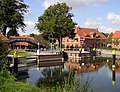
Plau am See
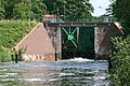
Bobzin
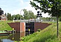
Garwitz

Lewitz


Old Elde

Are to be distinguished
- the Alte Elde as the Elde and flowing further below the junction of the shipping at Eldena into the Elde Lateral Canal
- the numerous parts of the original river course ( oxbow lake ), often winding-rich , which have been preserved in addition to the Elde, which is regulated and straightened above Eldena, and which are also mostly called Alte Elde .
The coming of Eldena and today at the Brandenburg ending Seedorf in the Löcknitz Alte Elde was rehabilitated in 2005 and 2006 in a cross-border (Mecklenburg-Western Pomerania and Brandenburg) project.
There is a longer continuous section of an oxbow lake north of the waterway east of Lübz near Kuppentin. Because of the occurrence of rare animal and plant species and the presence of almost natural water structures, it is designated as a nature reserve. Between Lübz and Parchim, the Alte Elde has been preserved on several sections, partly on the right and partly on the left of the waterway. Between the confluence of the Stör Canal and Neustadt-Glewe is the Altlauf, sometimes referred to as Elde on newer maps , to the right of the waterway. In Grabow , a piece of Alte Elde flows through the city center as it used to, and on to Güritz on the left of the waterway.
Usage history
Early mention
The Elde is mentioned in a document published in the Mecklenburg Document Book from the year 786 about the foundation of the Diocese of Verden by Charlemagne . However, their authenticity is disputed. In 946 Otto I issued the diocese of Havelberg with a letter of endowment and dedication in which the northern border along the Elde up to its confluence with the Elbe was determined. In 1163 Heinrich the Lion named the Elde as the border of the Ratzeburg diocese up to its mouth.
Old plans and first works

After Lübeck was connected to the Elbe via the Stecknitz voyage on the waterway in 1398 , Wismar , which specializes in salt trading , fell behind. They were also looking for a direct waterway on which Lüneburg salt could be brought from the Elbe to Wismar. One of the projects envisaged a connection via the Boize and the Schaalsee to the Schweriner See. The Mecklenburg dukes Magnus II and Balthasar had already tried to set up shipping traffic across the Elde . But neither the dukes nor the city of Wismar saw themselves in a position to finance the project. Wismar sought, among other things, unsuccessfully in Magdeburg for financial aid. Another problem was the lack of usage rights for a short Elde section on Brandenburg territory. The project was only mentioned again in 1531 under Duke Albrecht VII . He had married Princess Anna, a daughter of Elector Joachim I of Brandenburg , and hoped in this way and through diplomatic relations with neighboring princes and estates, from whom he solicited financial support, to convince the Brandenburgers of the benefits of a shipping route.
In 1566 Duke Johann Albrecht I had four locks built on Stör and Elde. On an arduous journey, on which the boat had to be pulled over several shallow areas despite a draft of only 60 cm, a commission, of which Tilemann Stella belonged as Johann Albrecht's representative , traveled from Viecheln on the north shore of Lake Schwerin to Dömitz. Joachim II , Elector of Brandenburg, was not convinced of the usefulness of a shipping route, so that Stella did not include the lower section of the Elde in his plans. Work on the lock in Gorlosen near the Brandenburg border has been stopped.
The construction of the Elde Lateral Canal in the 16th century
One way out was to build a direct water connection from Eldena to Dömitz in Mecklenburg. The advantage that the Mecklenburg side could receive all customs revenue outweighed the disadvantage of potential conflicts with the Brandenburg neighbors.
The terrain to be traversed was explored and measured from April to May 1568. In August of that year, work began on the moat between Dömitz and the Brantlewe , a swampy wood near the city. Eldena also worked its way forward. A tax was levied nationwide in April 1569, from which only the knighthood was exempt. Wall master Jost Spangenberg announced that the work would end soon. The project suffered a setback in August 1571 when Johann Georg , Elector of Brandenburg, had four locks and parts of the moat destroyed by nobles, farmers and servants shortly after taking office. He threatened the sewer workers with death if they continued their work. Elector August of Saxony arbitrarily intervened in the dispute.

In February 1572 the canal connection between Eldena and Dömitz, the Neue Elde, with seven locks was as good as completed. With the exception of a stone lock in Dömitz, the locks were made of wood. On August 11, 1572, the first ship on the canal reached Dömitz. After Duke Johann Albrecht ordered the locks to be enlarged and deficiencies repaired, the cities of Magdeburg and Hamburg were finally informed on March 15, 1575 that the new voyage was navigable in both directions. Continuous shipping from Viecheln on the north bank of the Schweriner See to the Elbe was thus possible.
The navigable connection from Lake Schwerin to Wismar, the so-called Viechelnsche Fahrt or later the Wallensteingraben , which had been planned since 1480 , was never completed and parts that had already been built fell into disrepair.
Eld expansion in the 19th century

The economic development in the beginning of the 19th century suggested a further expansion of the shipping routes in the area of the Elde. For example, connecting routes between the lakes, so-called Reeken, at Waren and at Plauer See were widened to 40 feet and, from 1798 to 1803, lock and mill systems were modernized. In 1831 the Elde-Actien-Societät was formed , which made the Elde navigable from the Müritz to the Elbe, the Stör to the Schweriner See and the connection from the Müritz to the Havel. The state of Mecklenburg wanted to cover a third of the total cost of 400,000 Reichstalers . The most important project was the construction of the Friedrich-Franz Canal from 1832 to 1834 above Neustadt-Glewe, which shortened the original course of the Elde in the Lewitzbruch . It is designed as a dam stretch, which means that the water level is above the level of the surrounding landscape. In addition, locks were renewed or newly constructed; the old interference channel was deepened. At the same time, the creation of a connection between the Elde and the Havel via the Müritz through the construction of the Bolter Canal . The water level of the Müritz, which had already fluctuated due to dammed mills, fell by a total of 1.30 meters between 1798 and 1836 during the Elderegulations.
Although the Elde-Actien-Societät first had to take out loans due to increased construction costs, in the first few years the income from lock fees was sufficient to generate a small profit. Since the end of the 1840s, competition from railways, such as the Berlin-Hamburg Railway , became more and more noticeable. In 1857 the company had to cede its rights to the sovereigns, who also took over the debts. Furthermore, the limitation of ship sizes proved to be a disadvantage. The buildings were originally designed for a 20 load (around 50 tons), later a limit of 25 load was prescribed. The construction of individual river straightenings, such as the Grabower and Güritz Canal downstream from Grabow, was not enough.
In an expert opinion for the state government, the Berlin building officer Adolf Wiebe stated in 1877 that the Mecklenburg waterways could never accommodate large amounts of through traffic. However, he considered an expansion for ships of 40 meters in length and up to 2500 quintals (125 tons) to be sensible. After lengthy negotiations, the state parliament of 1890 decided to expand; 1.5 million marks were approved from state funds.
One of the most important construction measures was the expansion of the canals (Elde side canals and lock canals) between Dömitz and Grabow and north of Neustadt. Further canal construction projects, such as the renewed expansion of the Wallensteingraben or a connection from Rostock to Berlin via Warnow , Nebel , Krakower and Plauer See as well as the Müritz were in prospect or were already being tackled (e.g. with the Bützow-Güstrow Canal ) taken. In this context, an eight-kilometer-long lock canal section between Grabow and Neustadt was already designed for 51.5-meter-long ships weighing up to 7,000 hundredweight (350 tons) and was completed in autumn 1895. Remaining work took place in 1896 and 1897. The construction costs had risen to a little over two million marks.
Working in the 20th century

Even without a connection to the Baltic Sea, the Elde was very important because of the transport of agricultural products to Hamburg. In 1921, extensive regulations began again on the course of the river, which were continued in the 1930s. Among other things, they served the purpose of establishing a fast and safe connection from Hamburg to Berlin via the Elde. The water level on the Elbe above Dömitz was not stable enough compared to that of the Elde and Havel. By combining barrages, higher heads should be achieved at the locks for the profitable operation of hydropower plants . Although the majority of these plans were not carried out, the Elde remained an important transport route up to and including the GDR era, on which manufacturing industries also settled. After the Wall was built in 1961, the access to the Elbe was closed.
In 1973 the estuary of the Löcknitz was relocated from Klein Schmölen downstream to the vicinity of Wehningen . The Löcknitz is led through a culvert under the Elde Lateral Canal near Dömitz .
In the 1970s, an artificial water connection from the Elde to the Rögnitz , the so-called Elde-Rögnitz-Überleiter , was created to drain and irrigate agricultural areas .
After 1990 the passage to the Elbe was freely passable again. Due to the extensive collapse of industry in the region, however, the Elde is practically no longer of any importance for cargo shipping. Today it is mainly used for tourist traffic.
Eldem estuary and Dömitz harbor

The mouth of the Elde was relocated several times. Stella's map from 1576 (see above) suggests that the Elde was approaching the Elbe south of Dömitz before the Neue Elde was built, but only flowed northwest into the river after circumnavigating the city to the east. A map by geometer Gerhart Evert Pilooth from 1612 shows a stone sluice at the mouth of the Neue Elde with the inscription "Hyr compt der Nye Elde through thiss steinen Släysz in the olden Elde". The lock was renovated in 1722 and 1823 and surrounded by a jump to protect it from raids . It is no longer used, but has been preserved and is a listed building. A map of Mecklenburg from 1645 also shows an approach of the Alte Elde with a connection to the Elbe at Klein Schmölen and then flowing around Dömitz to the east. Later the Alte Elde flows into Klein Schmölen and the bed called Dove Elde near Dömitz forms a branch of the Elbe.
During the Elderegulation from 1831 to 1836, the confluence of the Elde Lateral Canal into the Elbe branch was relocated, and from 1835 to 1836 a chamber lock with walls made of solid brickwork and a new ship berth were built. The system included a lateral fall sluice through which the dammed Eldewater could drain into the side arm. It became possible to get to Schwerin with ships up to 40 meters long.
During the construction of the Dömitz railway bridge from 1871 to 1873, the mouth of the Elde Lateral Canal was laid again, this time directly into the Elbe, with the excavation of the new river bed being used for the railway embankment leading to the bridge. A new port was built by 1890, which was connected to the Lüneburg-Wittenberge railway line . An expansion of the harbor basin planned in 1934 was not implemented. In 1938 a still-preserved granary was built as a reinforced concrete cell silo that was secure against air raids.

After the Second World War, the port in Dömitz initially retained its importance, as a corresponding infrastructure for freight transport by rail was not yet available again to the extent required. However, because of the border location with the British zone of occupation , there were initial restrictions. As a replacement for grain transports from the Soviet Union to Czechoslovakia that had previously been carried out via the Port of Hamburg, a grain handling facility was built in the 1950s, which should enable grain deliveries by rail from the Wismar port. However, it was no longer used, as the handling of goods in Dömitz was completely abandoned with the border security from 1961. The port became a border boat base. In 1973, the port was surrounded with high fences in order to be able to remove Dömitz from the five-kilometer exclusion zone. The port and lock were neglected. Before the Dömitz harbor and the Elbe connection of the Elde canal were put back into operation after 1989, the chamber lock, from which a wall had to be demolished in the mid-1980s because of dilapidation, was renewed. Parts of the grain transhipment facility were demolished in 1990. Its part, built as a reinforced concrete structure, will be used for catering after a renovation.
Hydropower plants

Of the total of 22 hydropower plants in Mecklenburg-Western Pomerania, nine are located on the Elde and the Elde Lateral Canal. In this section of the river, the gradient is about 50 meters. The systems are mostly located next to or close to the locks and use their free flow (water that is not required for locks).
These are the hydropower plants (see also section: locks) in Barkow , in the Bobzin district of Lübz, in the Malchow district of Dammer , in Neustadt-Glewe (two systems: Lewitz lock and the Neustadt-Glewe power station on a branch of the Elde in the city center) , in Grabow (two plants: Hechtsforthschleuse and Bolbrüggesche Mühle on the Alte Elde in the city center) and in Neu Kaliss (two plants: Findwirunshier, Neu Kaliss near the paper mill).
natural reserve

The Elde runs through a national park and eight nature reserves (NSG).
- The Mönchsee nature reserve is located on the upper reaches , a flat lake with surrounding silting moor, which is a breeding and resting place for water birds.
- On and partly in the Müritz are the Müritz National Park and the NSGe Müritzsteilufer near Rechlin and Großer Schwerin and Steinhorn .
- The NSGe Damerower Werder and the Blüchersches Bruch and Mittelplan, which is strongly influenced by fluctuations in the water level of the Kölpinsee, are located on the Kölpinsee .
- With the protection of the north bank of the Plauer See area , the preservation, maintenance and development of a landscape with lakes, moors, forests and wet meadows is pursued.
- The original course of the Elde is in the area of Alte Elde near Kuppentin to preserve the species-rich fish fauna and the adjacent wet meadows and forests under nature protection.
- To the north of Neustadt-Glewe, the original and dam-regulated Elde pass through the Fischteiche nature reserve in the Lewitz . The water level of the ponds on both sides of the dam-regulated Elde is lower than that of the waterway.
literature
- Bodo Müller: From the Elbe to Müritz. 4th edition, Edition Maritim, Hamburg 2005, ISBN 3-89225-256-4 .
- Friedrich Stuhr : The Elbe-Baltic Sea Canal between Dömitz and Wismar. In: Association for Mecklenburg History and Archeology: Yearbooks of the Association for Mecklenburg History and Archeology. - Volume 64 (1899), pp. 193-260 digitized version ( memento of September 26, 2007 in the Internet Archive ).
- Martin Eckoldt (Ed.): Rivers and canals, The history of the German waterways. DSV, Hamburg 1998, ISBN 978-3-88412-243-3 .
Web links
annotation
- ↑ According to his own statement, this was based on the recording of local topographers in the 1950s and 1960s. As was learned after correspondence with the state office, the keeping of the maps up to date will follow the reading of the state office for the environment, nature conservation and geology Mecklenburg-Western Pomerania, which for its part set the Eldelauf in consultation with the local water and soil association Müritz. However, the source of Elde will no longer be explicitly identified as such. ( Pictures of the ditch source at Knüppeldamm )
Individual evidence
- ^ German Hydrological Yearbook Elbe Region, Part III 2013. (PDF) ISSN 0949-3654. Free and Hanseatic City of Hamburg, Hamburg Port Authority, p. 135 , accessed on October 4, 2017 (German, at: dgj.de).
- ↑ Information from the Federal Statistical Office
- ↑ a b c Lengths (in km) of the main shipping routes (main routes and certain secondary routes) of the federal inland waterways ( memento of the original from January 21, 2016 in the Internet Archive ) Info: The archive link was automatically inserted and not yet checked. Please check the original and archive link according to the instructions and then remove this notice. , Federal Waterways and Shipping Administration
- ↑ a b c d Chronicle of the legal status of the Reich waterways / inland waterways of the Federation in the territory of the Federal Republic of Germany after October 3, 1990 ( Memento of the original of July 21, 2014 in the Internet Archive ) Info: The archive link was automatically inserted and not yet checked . Please check the original and archive link according to the instructions and then remove this notice. , Federal Waterways and Shipping Administration (PDF, 1.0 MB)
- ↑ LUNG: Biotope description field wood with Elde spring northeast. Knüppeldamm (PDF file; 21 kB), accessed on April 18, 2010
- ↑ LUNG: habitat description N. Quellried B198 Darzer firs. (PDF, 18 kB), accessed 18 April 2010
- ↑ old map published by LUNG with entry Elde between Darze and Fincken (search term: "Altenhof")
- ^ Entry Elde in Meyers Konversationslexikon , Verlag des Bibliographisches Institut, Leipzig and Vienna, 4th edition, 1885-1892
- ↑ a b Gustav Hempel: Geographical-statistical-historical manual of the Meklenburger Land , Frege, 1837
- ↑ So named in: Friedrich August von Rudloff: Neuere Geschichte von Mecklenburg , 2nd volume, 1822
- ↑ a b Keyword Elde In: Meyers Konversationslexikon , 4th edition, 1885-1892
- ↑ a b various maps, example , example 2
- ↑ a b Keyword Elde in: Meyers Großes Konversationslexikon , 6th edition, 1905–1909
- ↑ various maps, example
- ↑ Reinhard E. Fischer : The place names of the states of Brandenburg and Berlin. Age - origin - meaning. be.bra Wissenschaft, Berlin 2005, ISBN 978-3-937233-30-7
- ^ Keyword Elde, in: Meyers Neues Lexikon Bibliographisches Institut Leipzig, 1965
- ↑ Atlas engine for tourism, Berlin 1964
- ^ Reichsverkehrsblatt A 1936 p. 31
- ↑ various maps
- ↑ Müritz-Elde and Stör-Wasserstraße on the website of the Lauenburg Waterways and Shipping Office
- ↑ Electronic Waterways Information System (ELWIS) ( Memento from November 15, 2012 in the Internet Archive ) (PDF, 188 kB)
- ↑ The Elbe from the mouth of the Havel to the Geesthacht weir ( Memento of the original from December 14, 2007 in the Internet Archive ) Info: The archive link was automatically inserted and has not yet been checked. Please check the original and archive link according to the instructions and then remove this notice. - International Commission for the Protection of the Elbe (PDF file; 9.4 MB)
- ↑ Report of the Allianz Environmental Foundation ( Memento of the original from January 18, 2016 in the Internet Archive ) Info: The archive link was inserted automatically and has not yet been checked. Please check the original and archive link according to the instructions and then remove this notice. , accessed January 18, 2016.
- ↑ Ordinance on the Alte Elde nature reserve near Kuppentin ( Memento from July 11, 2012 in the web archive archive.today ) (1995)
- ↑ Hans Ullrich Thee, When the Elde was first mentioned , Schweriner Volkszeitung January 6, 1979
- ↑ a b c d e f g Bernd Klinghammer: On rivers and canals in Mecklenburg. On the history of the Elbe-Elde-Müritz waterway in Mecklenburg and the inland ports of Schwerin, Dömitz and Waren. in Monument Protection and Preservation in Mecklenburg-Western Pomerania , Obotritdruck Schwerin, Schwerin 2001, Issue 8, pp. 20–26
- ↑ a b c d e Friedrich Stuhr, The Elbe-Baltic Sea Canal between Dömitz and Wismar. In: Yearbooks of the Association for Mecklenburg History and Archeology . - Vol. 64 (1899), pp. 193-260, digitized
- ↑ a b c d e Horst Zänger: Herring on a long journey. After lengthy disputes, Neue Elde-Fahrt opened 425 years ago. , Mecklenburg-Magazin of the Schweriner Volkszeitung, May / June 1997
- ↑ a b c d Ewald Jörn, The construction of the new ditch near Dömitz 1568-72 , in: 700 years fortress Dömitz, special edition of the Mecklenburg monthly issues , 1935, Hinstorff Verlag, Rostock digitized
- ↑ Fred Ruchhöft: The water level of the "Upper Lakes" in Mecklenburg in the Middle Ages and early modern times in: Archaeological reports from Mecklenburg-Western Pomerania, Vol. 6, 1999
- ^ Henry Gawlick, in: The Griese area in photographs by Karl Eschenburg , ed. by Wolfhard Eschenburg, p. 23, Hinstorff Rostock, 2003
- ↑ Hans Czesienski: The most important problems of the Müritz-Elde-Wasserstraße and the Upper Havel in H. J. Kramm (ed.): Geografischeberichte , VEB Hermann Haack, 9th year 1964, pp. 219–225
- ^ Company profile of the Wagner-Weinke surveying office ( memento from April 2, 2013 in the Internet Archive ), Schwerin / Güstrow
- ↑ monument list ( Memento of 2 April 2013 Internet Archive ) of the district Ludwigslust
- ↑ Mecklenburg map from 1645 - griesegegend-online.de (The map turns out to be flawed in some details, such as the course of the Oberwarnow with its mouth in Lübz, the missing course of the Oberelde, the course of the fog)
- ↑ a b Jürgen Scharnweber: Elbehafen Dömitz. On the history of inland shipping between the Elbe and Elde. THORA-Verlag, Schwerin 1990.
- ↑ Water Framework Directive (WFD) - Flow regulations
- ↑ Water Framework Directive (WFD) - hydropower plants in Mecklenburg-Western Pomerania (map) (PDF, 789 kB)
- ^ Ministry of Environment Mecklenburg-Western Pomerania (ed.): The nature reserves in Mecklenburg-Western Pomerania , ISBN 3-910150-52-7