Massower See
| Massower See | ||
|---|---|---|

|
||
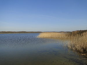
| Massower See from the Kornhorster shore | ||
| Geographical location | District of Mecklenburg Lake District | |
| Tributaries | Elde | |
| Drain | New Graben (Elde) | |
| Data | ||
| Coordinates | 53 ° 19 '22 " N , 12 ° 26' 32" E | |
|
|
||
| Altitude above sea level | 68.9 m above sea level NHN | |
| surface | 1.133 km² | |
The Massower See is a lake near the district of Massow in the municipality of Eldetal in the Mecklenburg Lake District in Mecklenburg-Western Pomerania . The water has a size of 113.3 hectares and is 68.9 m above sea level. NHN . The maximum size of the oval lake is 1600 meters by 800 meters. The main inflow is the Elde coming from the north, the outflow on the east bank is first called Neuer Graben before it becomes the Elde again. Other tributaries are ditches from the swamp forests on the north bank and the meadows in the southeast. The village of Massow lies in this direction, without directly bordering the lake.
There is a bathing area in the south-east corner of Lake Massower, which is also accessible from a circular cycle path through the Röbel-Müritz office . About one kilometer north of it is a Slavic rampart.
See also
Web links
proof
- ↑ Geodata viewer of the Office for Geoinformation, Surveying and Cadastre of Mecklenburg-Western Pomerania ( information )
