Nature reserve north shore Plauer See
|
Nature reserve north shore Plauer See
|
||
|
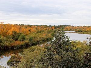
View from the "Moorochse" observation tower over the former peat cuttings in the NSG north bank of the Plauer See |
||
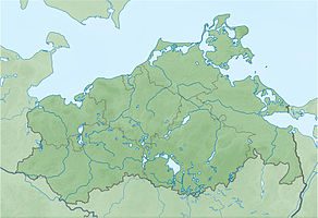
| location | Alt Schwerin and Plau am See , Mecklenburg-Western Pomerania , Germany | |
| surface | 6.31 km² | |
| Identifier | N 67 | |
| WDPA ID | 14356 | |
| Natura 2000 ID |
(FFH) DE-2339-402 (SPA) DE-2539-301 (FFH) DE-2339-402 (SPA) |
|
| Geographical location | 53 ° 32 ' N , 12 ° 18' E | |
|
|
||
| Setup date | 1960 | |
The nature reserve North Shore Plau is a 631 hectares comprehensive nature reserve in Mecklenburg between Karow (Plau) and Alt Schwerin . The expulsion took place on September 19, 1960 with an extension in 1990.
location
It includes the northwestern area of the Plauer See with wet meadows and former peat cuttings , the Hofsee to the west and a wooded part north of the federal highway 192 with the Samot See and Plumsee .
The nature reserve is located in the Nossentiner / Schwinzer Heide nature reserve . In addition, it is completely located in the FFH area DE-2539-301 Plauer See and the surrounding area and in the EU bird protection area DE-2339-402 Nossentiner / Schwinzer Heide , making it part of the European Natura 2000 network of protected areas .
The protected area can be walked on two public nature trails on Lake Samot and Lake Hofsee. To the south of the main road there is an observation tower in the area of the former peat cuttings.
History, water balance and protection purpose
The areas of today's nature reserve are embedded in an ice age drainage channel on the southern edge of a sander that formed in the Pomeranian stage of the last ice age . Postglacial pitched in the lakes to mighty to three meters muds from. Between the Samoter See and the Plauer See a flow moor formed with layers of peat up to three meters thick. On the Schmettauschen map from 1794, peat cuttings can be seen. The areas around the Samot Lake and the Moor Lake were used as arable land and were only afforested in the 19th century. With the construction of the railway line and the road between 1846 and 1848, the moor was divided. The water level was lowered through drainage measures.
The protection purpose consists in the maintenance of a structurally rich forest, lake and moor area. The current state of the area is only considered to be good, with the northern part of the protected area still being connected to drainage ditches, which has a negative effect on the protection purpose.
Flora and fauna
The lakes in the northern part of the area are bordered by a wide belt of wood with black alder , willow and marsh fern. The central part of the area consists of peat cuttings, from which the original bog vegetation is replaced by birch and alder forest.
The bittern , crane , kingfisher , gray shrike , snipe , puffy tit and cormorant are breeding birds in the reserve. Numerous species of ducks and geese use the open areas to rest in spring and autumn. Numerous bat species can be seen, including the great noctule bat , water bat , fringed bat , pipistrelle and brown long-eared bat . Otters live in this area.
literature
- North shore of Plauer See 67 . In: Ministry of Environment Mecklenburg-Western Pomerania (Hrsg.): The nature reserves in Mecklenburg-Western Pomerania . Demmler-Verlag, Schwerin 2003, ISBN 3-910150-52-7 , p. 556 f .
Web links
- NSG regulation
- Protected area presentation on a private website
- Map portal Umwelt MV with geodata (protected area borders, biotope mapping, etc.)
Individual evidence
- ↑ Ried biotope arch at the northern tip of the Rohrsee (PDF; 19 kB)
- ↑ Biotope arch quarry forest east of the Nature Park Office (PDF; 21 kB)


