
Priborn
| coat of arms | Germany map | |
|---|---|---|

|
Coordinates: 53 ° 18 ' N , 12 ° 40' E |
|
| Basic data | ||
| State : | Mecklenburg-Western Pomerania | |
| County : | Mecklenburg Lake District | |
| Office : | Röbel-Müritz | |
| Height : | 63 m above sea level NHN | |
| Area : | 15.33 km 2 | |
| Residents: | 357 (Dec. 31, 2019) | |
| Population density : | 23 inhabitants per km 2 | |
| Postal code : | 17209 | |
| Area code : | 039923 | |
| License plate : | MSE, AT, DM, MC, MST, MÜR, NZ, RM, WRN | |
| Community key : | 13 0 71 118 | |
| Office administration address: | Marktplatz 1 17207 Röbel / Müritz |
|
| Website : | ||
| Mayoress : | Elvira Doehring ( The Left ) | |
| Location of the municipality of Priborn in the Mecklenburg Lake District | ||
  |
||

Priborn is a municipality in the south of the Mecklenburg Lake District in Mecklenburg-Western Pomerania . It is administered by the Office Röbel-Müritz based in Röbel / Müritz .
geography

The community is located on the Müritzarm and the Müritzsee , at the southern end of the chain of lakes that runs south from the Müritz . Here, the leads Elde in the chain of lakes in the midst of a landscape conservation area, about five kilometers southwest of Rechlin and about ten kilometers south of the former county town Röbel / Müritz. The eastern border of the community is the Müritzarm, the western border is the Melzer See . To the south of the village there is an extensive, approximately 485 hectare forest area, the Priborn Heath . At the western end is at 82.4 meters above sea level. NN with the Wulfsberg the highest point in the community. Neighboring communities are Südmüritz , Buchholz and Melz .
history
Priborn is a Slavic foundation (tribe of the Obodrites ). The name is derived from "Pryborn" = "Fighter". The place was first mentioned in a document on May 26, 1239 when the water mill was leased. Prince Nikolaus von Werle signed a long lease with the Amelungsborn monastery . In 1285, his sons made Priborn the place of the land things (middle jurisdiction) in the country of Röbel.
On March 17, 1291, the mill came back into the possession of the princes in return for a share in the fishing rights in the Müritz . In 1302 the mill was owned by Counts Burchart and Ullrich von Lindow . The watermill has not been mentioned since the end of the 17th century. In the Middle Ages there were several changes of ownership of the village.
From 1732 the von Ferber family owned Priborn, Melz and Karbow. Ernst von Ferber built the two-story manor house between 1870 and 1880. The neo-Gothic village church was built during this time. In 1883 four free farms were mentioned. In 1943 the first electrical connections were laid in the village. On May 2, 1945, the village was occupied by Soviet troops without a fight. The last owner of the estate was Horst von Ferber until the land reform in 1945. In 1945 there were 214 residents in Priborn, more than half of whom were resettlers and refugees.
In the GDR Priborn developed into a "model village ", whereby the LPG and its chairman Fritz Dallmann shaped life in the village.
politics
Community representation
- Left : 1
- Flat share : 3
- Non-attached : 2
The mayor is provided by the left .
Coat of arms, flag, official seal
The municipality has no officially approved national emblem, neither a coat of arms nor a flag. The official seal is the small state seal with the coat of arms of the state of Mecklenburg. It shows a looking bull's head with torn off neck fur and crown and the inscription "GEMEINDE PRIBORN".
Sights, facilities
→ See also the list of architectural monuments in Priborn
- Manor house from 1880; it served as a school from 1945 to 2003. In 2005 a comprehensive usage concept for a recreation hotel was created.
- Neo-Gothic brick village church of Priborn from around 1860
- Outdoor pool on the Müritzarm
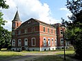
Former manor house


Web links
Individual evidence
- ↑ Statistisches Amt MV - population status of the districts, offices and municipalities 2019 (XLS file) (official population figures in the update of the 2011 census) ( help ).
- ↑ main statute § 1
- ^ Gutshaus Priborn - Diploma thesis 2005 on the use of Dipl.-Ing. Jeanette Seifert, accessed July 12, 2015
Alt Schwerin | Altenhagen | Altenhof | Altentreptow | Ankershagen | Bartow | Basedow | Beggerow | Ownership | Blankenhof | Blankensee | Flower wood | Bollewick | Borrentine | Bredenfelde | Breesen | Breest | Briggow | Brunn | Buchholz | Stargard Castle | Burow | Bütow | Carpin | Cölpin | Dargun | Datzetal | Demmin | Eldetal | Rotten rust | Feldberger Seenlandschaft | Fincken | Friedland | Five lakes | Galenbeck | Gielow | Gnevkow | Godendorf | Goehren-Lebbin | Golchen | Gotthun | Grabowhöfe | Grammentin | Grapzow | Grischow | Large trowel | Groß Miltzow | Gross Nemerow | Large plastic | Groß Teetzleben | Grünow | Validity | Gülzow | High Wangelin | Hohenbollentin | Hohenmocker | Hohenzieritz | Holldorf | Ivenack | Jabel | Jürgenstorf | Kargow | Kentzlin | Kieve | Kittendorf | Little Thank You | Kletzin | Klink | Klocksin | Knorrendorf | Kratzeburg | Kriesow | Sublank | Kuckssee | Kummerow | Larz | Leizen | Lindenberg | Lindetal | Malchin | Malchow | Meesiger | Melz | Mirow | Möllenbeck | Möllenhagen | Mölln | Moltzow | Neddemin | Neetzka | Neubrandenburg | Neuenkirchen | Recalculation | Neustrelitz | Neverin | Nossendorf | Nossentiner Hut | Peenehagen | Penkow | Penzlin | Pragsdorf | Priborn | Priepert | Pripsleben | Rechlin | Ritzerow | Röbel / Müritz | Röckwitz | Rosenow | Sarov | Schloen-Dratow | Schönbeck | Schönfeld | Schönhausen | Black | Siedenbollentin | Siedenbrünzow | Sietow | Silz | Sommersdorf | Sponholz | Staven | Stavenhagen | Steer | Südmüritz | Torgelow am See | Trollenhagen | Tützpatz | Userin | Utzedel | Forgive | Voigtsdorf | Vollrathsruhe | Walow | Waren (Müritz) | Warrenzin | Werder | Wesenberg | Wildberg | Woggersin | Wokuhl-Dabelow | Wolde | Woldegk | Wulkenzin | Wustrow | Zettemin | Zirzow | Zislow