
Sarov
| coat of arms | Germany map | |
|---|---|---|

|
Coordinates: 53 ° 48 ' N , 13 ° 6' E |
|
| Basic data | ||
| State : | Mecklenburg-Western Pomerania | |
| County : | Mecklenburg Lake District | |
| Office : | Demmin country | |
| Height : | 54 m above sea level NHN | |
| Area : | 33.61 km 2 | |
| Residents: | 703 (Dec. 31, 2019) | |
| Population density : | 21 inhabitants per km 2 | |
| Postal code : | 17111 | |
| Area code : | 039996 | |
| License plate : | MSE, AT, DM, MC, MST, MÜR, NZ, RM, WRN | |
| Community key : | 13 0 71 128 | |
| Community structure: | 4 districts | |
| Office administration address: | Goethestrasse 43 17109 Demmin |
|
| Mayor : | Friedhelm Wyrwich | |
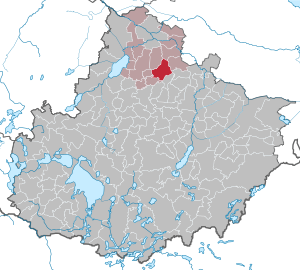
| Location of the municipality of Sarow in the Mecklenburg Lake District | ||
  |
||

Sarow is a municipality in the Demmin-Land district in the north of the Mecklenburg Lake District in Mecklenburg-Western Pomerania . Historically it belongs to Western Pomerania .
Geography and traffic
Sarow is about 14 kilometers southeast of Demmin and 23 kilometers northeast of Stavenhagen . The federal highway 194 runs west of the community. The Augraben flows through the northwest of the municipality .
Districts
- Sarov
- Ganschendorf
- Gehmkow
- Body
history
Sarov
The oldest mention of the place Sarowe is from March 5, 1266 . In a letter, Duke Barnim I of Pomerania confirmed to the Dargun monastery that all possessions and rights transferred to him by his ancestors and himself were “In Villa Sarowe Duo mansi” (two hooves in the village of Sarowe). In 1331, Sarov Castle was mentioned in a papal feudal letter to the Pomeranian dukes. The Voss family has been traceable in Sarow since 1356 . The Ganschendorf estate was Pertinenz (secondary property ) to Sarow until 1485 . In 1516, all the pledged goods from Achim Voss came to Joachim von Maltzahn . In 1527 Jakob Voss tried to buy back his pledged goods from the Maltzahns. These are said to have taken his money from him while drinking and playing cards. Voss set fire to Sarow, Ganschendorf and Carin in revenge ; he was convicted and executed for it.
In the Thirty Years War Sarov was completely devastated and the church destroyed. During this time, General Wallenstein stayed briefly with his troops in Sarower Castle. After a break from 1679 to 1737 in the possession of Moritz von Walsleben, the goods belonged again to those of Maltzahn.
In 1849 the Sarow estate was sold to Friedrich von Meyenn , then it belonged to the Counts of Heyden-Linden zu Kartlow. It was last managed by the tenant Böbs. The last owner of the 1000 hectare estate was Harald von Heyden-Linden until 1945.
Until 2004, Sarow belonged to the Borrentin office , since 2011 to the new Mecklenburg Lake District.
Body
Tbodin is located east of the excavation on the highway 27 between Altentreptow and Demmin . There is a small lake on the outskirts (Tbodiner See). Originally it was a slave settlement of the Tollensians , a tribe of the Wilzen , from the 10th century. The place name comes from that time and indicates the locator (Tbodyin = place of the "Trpa"). The place Tbodin - more precisely the Tbodin Church - was first mentioned in a document in 1404. In the middle of the 19th century, Tbodin developed into a prosperous place with farmers, craftsmen, traders and traders. At that time there had more than 700 inhabitants. There was a school, a smithy and Carl Reichheim's inn with horse-drawn equipment, a guest room and a small shop. In 1958 the Agricultural Production Cooperative (LPG) was founded. From 1973 to 1975, cooperatives for plant and animal production were formed by merging several cooperatives. The Tbodiner dairy worked until 1976 and subsequently a cheese dairy was located here until 1991 as a subsidiary of Altentreptow. After the fall of the Wall, Helmut Georg Pratzel founded the “Tbodiner Forum e. V. ". The association organizes a variety of innovative projects in town.
The Tbodin church is located on a hill with an unused churchyard . The old church with tower - first mentioned in 1404 - was rebuilt without a tower in 1660 and thoroughly renovated in 1967. A wooden belfry stands in front of the church. There is a Grüneberg organ built in 1663 in the church .
In December 2013, the ARD documentary series “Exklusiv im Erste” showed the film “Tbody must not die”. An NDR film team around Anne Kathrin Thüringer shot it in 2013. Today around 240 mostly elderly residents live in the place.
Gehmkow
Gehmkow was probably named Stolzow in the 10th – 11th centuries . Settled in the 19th century. The place and the church were first mentioned in documents in 1325. In the 16th century, the Drake family, who can be verified as councilors and mayors in Altentreptow, owned a knightly seat there. When Tönies Drake died out in 1579, the property fell to the Duke of Pommern-Wolgast and was divided between the offices of Verchen / Lindenberg and Treptow / Klempenow. Gehmkow belonged to the Verchen / Lindenberg office. In the 17th century it was pledged to Georg Platen, and in the course of the reduction in goods in the 1690s it was returned to the Lindenberg district, to which it still belonged at the end of the 18th century.
In the 19th century, when the Lindenberg office was dissolved, the Vorwerk was sold and turned into a manor. In 1865 it was owned by the von Pressentin family. Later the Heyden came from different branches of the family e.g. B. Heyden-Linden, who stayed there until 1945. The last owner was Bogislaw von Heyden-Linden (1872-1946). Organizationally, the place belongs to the Hohenbollentin parish.
politics
Coat of arms, flag, official seal
The municipality has no officially approved national emblem, neither a coat of arms nor a flag . The official seal is the small state seal with the coat of arms of the region of Western Pomerania . It shows an upright griffin with a raised tail and the inscription "GEMEINDE SAROW * LANDKREIS MECKLENBURGISCHE SEENPLATTE".
Attractions
- Ganschendorf Church , neo-Gothic brick building
- Burgwall Ganschendorf a middle Slavic hill fort
- Attractions

Excavation near Gehmkow

Ganschendorf manor house


Sons and daughters (selection)
- Dietrich von Heyden-Linden (1898–1986), physicist and photographer
literature
- Hubertus Neuschäffer: Western Pomerania's castles and mansions. Husum Druck- und Verlagsgesellschaft, 1993, ISBN 3-88042-636-8 , p. 60 ff.
Individual evidence
- ↑ Statistisches Amt MV - population status of the districts, offices and municipalities 2019 (XLS file) (official population figures in the update of the 2011 census) ( help ).
- ^ Dirk Schleinert: The estate economy in the Duchy of Pommern-Wolgast in the 16th and early 17th centuries. Cologne / Weimar / Vienna 2001, p. 139f.
- ↑ Protocol of the Swedish surveyor dated June 16, 1698, Link: gis.uni-egoswald.de , accessed on August 16, 2017.
- ^ Ludewig Wilhelm Brüggemann: Detailed description of the current state of the Königl. Prussian Duchy of Western and Western Pomerania. Volume I, Stettin 1770, p. 93.
- ^ Heinrich Berghaus: Landbuch des Duchy of Stettin etc. Volume I, Anklam 1865, p. 53f.
- ↑ Main Statute, Section 1, Paragraph 2 (PDF).
Web links
Alt Schwerin | Altenhagen | Altenhof | Altentreptow | Ankershagen | Bartow | Basedow | Beggerow | Ownership | Blankenhof | Blankensee | Flower wood | Bollewick | Borrentine | Bredenfelde | Breesen | Breest | Briggow | Brunn | Buchholz | Stargard Castle | Burow | Bütow | Carpin | Cölpin | Dargun | Datzetal | Demmin | Eldetal | Rotten rust | Feldberger Seenlandschaft | Fincken | Friedland | Five lakes | Galenbeck | Gielow | Gnevkow | Godendorf | Goehren-Lebbin | Golchen | Gotthun | Grabowhöfe | Grammentin | Grapzow | Grischow | Large trowel | Groß Miltzow | Gross Nemerow | Large plastic | Groß Teetzleben | Grünow | Validity | Gülzow | High Wangelin | Hohenbollentin | Hohenmocker | Hohenzieritz | Holldorf | Ivenack | Jabel | Jürgenstorf | Kargow | Kentzlin | Kieve | Kittendorf | Little Thank You | Kletzin | Klink | Klocksin | Knorrendorf | Kratzeburg | Kriesow | Sublank | Kuckssee | Kummerow | Larz | Leizen | Lindenberg | Lindetal | Malchin | Malchow | Meesiger | Melz | Mirow | Möllenbeck | Möllenhagen | Mölln | Moltzow | Neddemin | Neetzka | Neubrandenburg | Neuenkirchen | Recalculation | Neustrelitz | Neverin | Nossendorf | Nossentiner Hut | Peenehagen | Penkow | Penzlin | Pragsdorf | Priborn | Priepert | Pripsleben | Rechlin | Ritzerow | Röbel / Müritz | Röckwitz | Rosenow | Sarov | Schloen-Dratow | Schönbeck | Schönfeld | Schönhausen | Black | Siedenbollentin | Siedenbrünzow | Sietow | Silz | Sommersdorf | Sponholz | Staven | Stavenhagen | Steer | Südmüritz | Torgelow am See | Trollenhagen | Tützpatz | Userin | Utzedel | Forgive | Voigtsdorf | Vollrathsruhe | Walow | Waren (Müritz) | Warrenzin | Werder | Wesenberg | Wildberg | Woggersin | Wokuhl-Dabelow | Wolde | Woldegk | Wulkenzin | Wustrow | Zettemin | Zirzow | Zislow