
Bollewick
| coat of arms | Germany map | |
|---|---|---|

|
Coordinates: 53 ° 21 ' N , 12 ° 35' E |
|
| Basic data | ||
| State : | Mecklenburg-Western Pomerania | |
| County : | Mecklenburg Lake District | |
| Office : | Röbel-Müritz | |
| Height : | 86 m above sea level NHN | |
| Area : | 26.69 km 2 | |
| Residents: | 636 (Dec. 31, 2019) | |
| Population density : | 24 inhabitants per km 2 | |
| Postal code : | 17207 | |
| Area code : | 039931 | |
| License plate : | MSE, AT, DM, MC, MST, MÜR, NZ, RM, WRN | |
| Community key : | 13 0 71 013 | |
| LOCODE : | DE 29B | |
| Office administration address: | Marktplatz 1 17207 Röbel / Müritz |
|
| Website : | ||
| Mayor : | Antje Styskal | |
| Location of the municipality of Bollewick in the Mecklenburg Lake District | ||
  |
||

Bollewick [ boˈleːvɪk ] is a municipality and " bioenergy village " in the southwest of the Mecklenburg Lake District in Mecklenburg-Western Pomerania . It is administered by the Office Röbel-Müritz based in the city of Röbel / Müritz .
geography
The municipality of Bollewick is located in the Mecklenburg Lake District , a few kilometers southwest of the Müritz . The municipal area between Müritz and Oberer Elde is characterized by fields, small forests and lakes, the highest point being the Mohrberg at almost 112 m above sea level. NN. Two settlement axes define the community: in a north-south direction on the road from Röbel / Müritz to Wredenhagen and in an east-west direction in a wide arc from Erlenkamp to Spitzkuhn. The city of Röbel is only three kilometers away.
Bollewick is surrounded by the neighboring communities Röbel / Müritz in the north and east, Melz in the south-east, Kieve in the south, Eldetal in the south-west and Bütow in the west.
The districts of Nätebow, Spitzkuhn and, since June 7, 2009, Kambs and Wildkuhl also belong to Bollewick .
history
Bollewick The name Bollewick with its components bolle (round, bulbous) and wick (Germ. Suffix wig , wik = place or village, borrowed from the Latin vicus = village) means round village .
Two large stone graves near the village testify to the early settlement of the area . Bollewick was founded as a district of Nedebuh (today Nätebow) in the 13th century by the knight of Werle Konrad Büne. It was first mentioned on January 21, 1261. The village was then about 1200 meters further west on the almost circular Wackstower See .
The site was abandoned, probably because of the high groundwater level on the lake shore. At the beginning of the Thirty Years' War the village was already in desolation. Bollewick was laid out as a long street village at the current location from the 18th century. After frequent changes of ownership and gradual reconstruction, the community was increasingly settled in the early 1930s.
Kambs Bishop Heinrich von Havelberg received the patronage of the church of Kambs in the Middle Ages around 1330 through an exchange from Prince Johann III. from Werle . Since 1295 the village was partly in the hands of the von Ketelhodt family, whose possession in 1790 passed to the von Flotow family . passed over; soon thereafter it was a ducal / state domain until 1945 . The von Moltke and von Maltzan families and, in the 15th century, the von Rohr , von Knuth and Reichknecht families owned shares in the village. The manor house, a single-storey half-timbered building from the beginning of the 18th century, fell into disrepair after 1945. An old horse stable is now a residential building.
politics
Coat of arms, flag, official seal
The municipality has no officially approved national emblem, neither a coat of arms nor a flag. The official seal is the small state seal with the coat of arms of the state of Mecklenburg. It shows a looking bull's head with torn off neck fur and crown and the inscription "GEMEINDE BOLLEWICK".
Attractions
- Barn Bollewick from 1881, a symbol of the community, is the largest field stone barn in Germany with a floor space of 125 × 34 meters. It was used for agriculture until 1991, when it was converted into an event center with a hotel and shops
- Early Gothic , cross-vaulted village church Nätebow made of brick, once a fortified church , then rebuilt and expanded several times. Equipment: carved altar from 1522, patron's box from 17th century
- Gothic village church Kambs made of field stone and with vault from the 13th century; the nave-wide west tower and the vestibule from the 14th century
- Wildkuhl estate (around 1883) with a timber-framed manor house , today a social farm community with an 82 hectare park
- 2006 created maze in Bollewick
- Great stone grave Bollewick 1
→ See also List of Monuments in Bollewick

Bollewick Barn
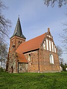
Nätebow village church

Kambs village church
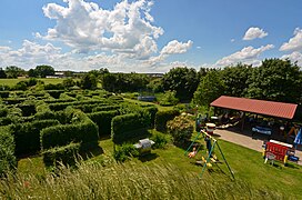
Part of the Bollewick Maze


Economy and Infrastructure
With many single-family houses and newly developed residential areas, Bollewick has meanwhile developed into an attractive village in which many traders have settled. Besides agriculture, tourism plays the most important role.
Bioenergy village
On July 6, 2010, a foundation stone and memorial stone for the construction of the first biogas plant in Bollewick was laid on the dairy farm of a Dutch farmer who had moved in, in the presence of Federal Agriculture Minister Ilse Aigner and State Agriculture Minister Till Backhaus . It is intended to help ensure that the place will receive a self-sufficient local heating network as a bioenergy village in the foreseeable future . Since February 2013, the waste heat from the plant, which primarily generates electricity, has been supplying 54 households and replacing heating with gas and oil.
Transport links
Bollewick is located on the connecting road from Röbel / Müritz to Bundesstraße 198 . The Röbel motorway junction on the 19 federal motorway (Berlin – Rostock) is around eight kilometers away. The next train stations are in Malchow and Waren (Müritz) .
Web links
Individual evidence
- ↑ Statistisches Amt MV - population status of the districts, offices and municipalities 2019 (XLS file) (official population figures in the update of the 2011 census) ( help ).
- ↑ http://www.wege-zum-bioenergiedorf.de/index.php?id=2117&GID=0&OID=1030&KID=24&firma=68
- ↑ StBA: Area changes from January 2nd to December 31st, 2009
- ↑ Manor houses and castles Mecklenburg-Western Pomerania: Kambs manor house near Röbel .
- ↑ main statute § 1
- ↑ http://www.irrgarten-bollewick.de/startseite/geschichte/ Homepage of the maze with data on history; Retrieved July 1, 2014
- ↑ Cf. Aigner relies on biomass as an energy source , dpa, July 6, 2010 [1]
- ↑ ndr.de: Bollewickers now heat with bioenergy (February 15, 2013)
Alt Schwerin | Altenhagen | Altenhof | Altentreptow | Ankershagen | Bartow | Basedow | Beggerow | Ownership | Blankenhof | Blankensee | Flower wood | Bollewick | Borrentine | Bredenfelde | Breesen | Breest | Briggow | Brunn | Buchholz | Stargard Castle | Burow | Bütow | Carpin | Cölpin | Dargun | Datzetal | Demmin | Eldetal | Rotten rust | Feldberger Seenlandschaft | Fincken | Friedland | Five lakes | Galenbeck | Gielow | Gnevkow | Godendorf | Goehren-Lebbin | Golchen | Gotthun | Grabowhöfe | Grammentin | Grapzow | Grischow | Large trowel | Groß Miltzow | Gross Nemerow | Large plastic | Groß Teetzleben | Grünow | Validity | Gülzow | High Wangelin | Hohenbollentin | Hohenmocker | Hohenzieritz | Holldorf | Ivenack | Jabel | Jürgenstorf | Kargow | Kentzlin | Kieve | Kittendorf | Little Thank You | Kletzin | Klink | Klocksin | Knorrendorf | Kratzeburg | Kriesow | Sublank | Kuckssee | Kummerow | Larz | Leizen | Lindenberg | Lindetal | Malchin | Malchow | Meesiger | Melz | Mirow | Möllenbeck | Möllenhagen | Mölln | Moltzow | Neddemin | Neetzka | Neubrandenburg | Neuenkirchen | Recalculation | Neustrelitz | Neverin | Nossendorf | Nossentiner Hut | Peenehagen | Penkow | Penzlin | Pragsdorf | Priborn | Priepert | Pripsleben | Rechlin | Ritzerow | Röbel / Müritz | Röckwitz | Rosenow | Sarov | Schloen-Dratow | Schönbeck | Schönfeld | Schönhausen | Black | Siedenbollentin | Siedenbrünzow | Sietow | Silz | Sommersdorf | Sponholz | Staven | Stavenhagen | Steer | Südmüritz | Torgelow am See | Trollenhagen | Tützpatz | Userin | Utzedel | Forgive | Voigtsdorf | Vollrathsruhe | Walow | Waren (Müritz) | Warrenzin | Werder | Wesenberg | Wildberg | Woggersin | Wokuhl-Dabelow | Wolde | Woldegk | Wulkenzin | Wustrow | Zettemin | Zirzow | Zislow