
Malchin
| coat of arms | Germany map | |
|---|---|---|

|
Coordinates: 53 ° 44 ' N , 12 ° 46' E |
|
| Basic data | ||
| State : | Mecklenburg-Western Pomerania | |
| County : | Mecklenburg Lake District | |
| Office : | Malchin at the Kummerower See | |
| Height : | 10 m above sea level NHN | |
| Area : | 108.7 km 2 | |
| Residents: | 7326 (Dec. 31, 2019) | |
| Population density : | 67 inhabitants per km 2 | |
| Postal code : | 17139 | |
| Primaries : | 03994, 03996, 039957 | |
| License plate : | MSE, AT, DM, MC, MST, MÜR, NZ, RM, WRN | |
| Community key : | 13 0 71 092 | |
| LOCODE : | DE MCN | |
| City structure: | Core city and 13 districts | |
City administration address : |
Am Markt 1 17139 Malchin |
|
| Website : | ||
| Mayor : | Axel Müller ( CDU ) | |
| Location of the city of Malchin in the Mecklenburg Lake District | ||
  |
||

Malchin is a small town in Mecklenburg-Western Pomerania in the northwest of the Mecklenburg Lake District . Historically, it belongs to the state of Mecklenburg . The place forms a basic center for its surroundings .
geography
Geographical location
Malchin is located in a depression on the Malchiner Peene between the Malchiner See , with which the city is connected via the Dahmer Canal , and the Kummerower See, which can be reached from the city via the Peene Canal, east of the densely wooded Mecklenburg Switzerland . This reaches heights of over 120 meters above sea level around the northwestern districts of Neu Panstorf, Retzow and Wendischhagen. NHN .
City structure
The following districts belong to Malchin:
|
|
|
|
|
history


Surname
The Slavic fishing settlement could once have borne the old Polish name Malochyni (derived from Maloch = small). In 1215 the place was called Malekin , then from 1247 Malechin or next to it Malchyn and 1257 also Malchin .
middle Ages
In 1215 the village of Malekin was mentioned in a document. From 1220, Nikolaus von Werle laid out the city as planned with a grid-shaped road network. The center of the grid was the market and the church. The town charter ( civitas ) was granted to Malchin on April 7, 1236 by Prince Nicholas I. The founding deed states that the city is "located in the richest and most beautiful area of the country on the Peene" . From the city fortifications from this time only the Kalensche Voror and the entrance of the stone gate as well as wall remnants and the Fangelturm , a high, rectangular defense tower remain .
The town church of St. Maria and St. Johannes was built around this time as a late Romanesque first building. In 1397, the city with the church was cremated by the great city fire. A new three-aisled Gothic brick church was built as a basilica .
Malchin became a state town in Mecklenburg and as such was one of the towns in the Wendish district that were represented on the Mecklenburg state parliaments of the states united in 1523 until 1918 . For centuries the city lay on the border between the Duchy of Mecklenburg-Schwerin and Pomerania .
17th to 19th century
According to the Neubrandenburg house contract , the city was one of the cities remaining under the communal government. In the course of the second main division of Mecklenburg after the Fahrholz partition treaty of 1621, Malchin came to the (partial) duchy of Mecklenburg-Güstrow .
In 1639, during the Thirty Years' War, the imperial, Electoral Saxon and Kurbrandenburg armies with about 80,000 men were encamped in and near Malchin. The city has been looted sixteen times. Hunger, plague, devastation, robbery and manslaughter and thus unimaginable hardship were the result.
After the Hamburg settlement , after the Güstrow line died out and subsequent long-term negotiations, Malchin was assigned to the Mecklenburg-Schwerin part of the country .
The city was affected in numerous wars, such as the Northern War , which lasted from 1700 to 1721, when Danish and Russian troops surrounded the city in 1713. During the Seven Years' War , the city was bombarded by the Prussians on New Year's Day 1762 from what is now called the Bataillenberg hill in order to drive out the Swedes. During the French period , on November 2, 1806, 15,000 French troops with Marshal Joachim Murat moved into the city; they also plundered.
A synagogue was built in Malchin in 1764 and a larger church was built in 1835. In 1925 the Jewish community dissolved. In 1838 a new mill bridge was built over the Ostpeene in front of the former mill gate. In 1833 a city hospital was built on the Strietfeld (old hospital) with an extension from 1859. In 1842 the town hall was rebuilt at the old location; it was completely redesigned in 1900.
Diets in Malchin and Sternberg
Since the division of the state of Mecklenburg 1621 (Güstrower Reversalen and Erbvertrag) in the two duchies Mecklenburg-Schwerin and Mecklenburg-Güstrow which met Diet of Mecklenburg corporate state by 1628 to 1916, alternately in Sternberg - ie in Mecklenburg , and in Malchin - ie in Wendische circuit .
By the so-called Hamburg settlement of March 8, 1701, Mecklenburg was divided into two limited autonomous (partial) duchies, from 1815 (partial) grand duchies - Mecklenburg-Schwerin and Mecklenburg-Strelitz - which formed a common state, the same since 1755 Had a constitution and - as before - were subject to a joint state parliament. This state constitution in Mecklenburg was in force until 1918.
The meeting of the estates were
- on the one hand country, convocation and deputation days , which the sovereign - the duke - convened,
- on the other hand, national conventions or knighthood or city conventions that were convened by the estates themselves.
The state parliament, convened every autumn, was the most important body in the state. Extraordinary state parliaments were rarely held, and just as rarely in other places (including Schwerin ).
The state parliaments met in the respective town halls of Sternberg and Malchin.
Founding period
Many facilities were built in Malchin during the founding period . In 1860 Carl Julius Voss founded a wool dyeing factory on Mühlenstrasse. In 1900 the company had 20 to 30 employees. The harbor was inaugurated in 1862. A steamship line Stettin - Demmin - Malchin was operated.
In 1864 the Güstrow – Malchin – Neubrandenburg railway was built . In 1864 the station was inaugurated with its - it was said - beautiful reception hall. From 1864 to 1870 Malchin was the seat of the administration for the Grand Ducal Friedrich Franz Railway . This was located in a representative building near the train station that was used by the tax office from 1921 . The Bahnhofshotel developed from an existing bowling alley around 1880.
In 1868 the inner gate and in 1872 the front gate of the Gothic Wargentiner gate from 1331 were demolished from brick. The Grand Ducal District Court building was built in 1879 . The city court previously met in the town hall. In 1881 the town mill was built on the Peene. In 1882 " the factory " was founded, a sugar factory on Fabrikstrasse. In 1886 the Imperial Post Office was inaugurated on Poststrasse next to Kalenschen Tor. On the Peene and the old city wall, the Brunswig Promenade was built from 1890, which was named after the Brunswig Councilor of Commerce . The new city hospital on Basedower Strasse began operations in 1893. From 1898 the window and sheet metal factory of Carl Reincke was established, a company that employed around 70 people in 1937, had its locations at Poststrasse 6, soon afterwards at Halbtonnenstrasse 7 and from 1910 at Wiesenstrasse 6 and was only given up in 1994.
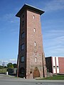
In 1902 the water tower and the machine houses were built in front of the stone gate, and in 1903 the central water supply went into operation. The street sewer system was also expanded.
Recent history
In 1926 the two offices of Stavenhagen and Dargun were merged to form the office of Malchin . From 1933 there was the Malchin district . The district office building was planned in the Bauhaus style by the architect Nicolai from Rostock and used from 1929.
During the Second World War , hundreds of prisoners of war as well as women and men from the countries occupied by Germany had to do forced labor in Malchin and the surrounding area , many of which died. After the invasion of the Red Army on April 30, 1945, around 3 ⁄ 4 of the old buildings in the city center were destroyed by arson, and around 500 people died by suicide .
Malchin was 1952-1994 county seat of the same circle that until 1990 the East German district Neubrandenburg belonged. Malchin was assigned to the enlarged Demmin district in 1994 . In 2005 the city lost its freedom of office and since then has been the seat of the Malchin am Kummerower See office and the administrative community in this office. Since the district reform in 2011, Malchin has been in the Mecklenburg Lake District .
The city center and town hall have been fundamentally renovated since 1991 as part of urban development funding. Across from the market, a new development with shops, offices and apartments was created on the basis of an urban development competition.
History of the districts
Remplin was first mentioned in a document in 1283. Owners were u. a. the families (von) Hahn (from around 1405 to 1816), Prince Georg Wilhelm von Schaumburg-Lippe (until 1848), von Maltzahn (until 1851) and Duke Georg of Mecklenburg . Remplin Castle , which was largely destroyed in 1940 , was built from 1865 according to plans by Friedrich Hitzig , the neo-Gothic church in 1878.
Scharpzow was a domain of the Domanialamt Stavenhagen . The tenant was u. a. in the 19th century Carl Theodor Müller, who was one of the bourgeois-liberal forces in the country. The manor house was created by converting an older building in the second half of the 19th century. It was a meeting point for time-sensitive people, u. a. Hoffmann von Fallersleben and Fritz Reuter .
Incorporations
On January 1, 1951, the previously independent community Scharpzow was incorporated. Gorschendorf has been part of Malchin since January 1st, 2003. On June 7th, 2009 Remplin was incorporated with the districts Neu Panstorf, Retzow and Wendischhagen after Malchin, which almost doubled the area of the city. On January 1, 2019, Duckow with the district Pinnow became part of Malchin.
Population development
|
|
Status: December 31 of the respective year
politics

City council
The city council of Malchin consists of 21 members and the mayor. Since the local elections on May 26, 2019, it has been composed as follows:
| Party / list | Seats |
|---|---|
| CDU | 6th |
| The left | 4th |
| Independent Malchiner Citizens Movement (UMB) | 4th |
| SPD | 3 |
| AfD | 3 |
| Individual applicant Martin Jahrmärker | 1 |
mayor
- 1994–2015: Jörg Lange (FDP)
- since 2015: Axel Müller
Müller was elected in the mayoral election on May 10, 2015 with 58.7% of the valid votes for a term of seven years.
coat of arms
|
|
Blazon : "In gold between two floating red towers, each with a quadruple tinned plate supported on both sides and seven (1: 2: 2: 2) day-lit windows, a looking, golden crowned black bull's head with a closed mouth, a knocked out red tongue and silver horns, elevated by a red paw cross. "
The coat of arms was established on April 10, 1858 by Grand Duke Friedrich Franz II of Mecklenburg-Schwerin, redrawn in 1994 and registered under the number 50 of the coat of arms of the state of Mecklenburg-Western Pomerania. |
| Reasons for the coat of arms: The coat of arms is based on the seal image of the SIGILLVM CIVITATIS MALECHIN - first handed down as an imprint in 1346 - and was determined in its current form in April 1858. It combines an urban symbol, a symbol of authority and a church symbol. The tin towers mark Malchin as a fortified and fortified city. The bull's head typical of the Werler line of the Mecklenburg Princely House reminds of Mr. zu Werle as the city's founder and lord. It is uncertain whether the cross should refer to the church belonging to the diocese of Cammin. |
- Historical coat of arms
 |
Blazon : "In gold between two red tin towers, a gold-crowned black bull's head looking forward with a closed mouth, a knocked-out red tongue and black horns."
The coat of arms was designed by Prof. Hans Herbert Schweitzer from Berlin . It was awarded on October 1, 1943 by the Reichsstatthalter in Mecklenburg. |
| Justification of the coat of arms: The coat of arms lost its validity soon after the end of World War II. |
flag
The flag was designed by the Malchiner J. Ludewig and approved on June 1, 1994 by the Ministry of the Interior.
The flag is evenly striped lengthways with yellow and red. In the middle of the flag, at two thirds of the height of the yellow and red stripes, is the city coat of arms. The relation of the height of the flag cloth to the length is like 3: 5.
Official seal
The official seal shows the city arms with the inscription "CITY MALCHIN".
Town twinning
- Szerencs ( Hungary ), since 1989
- Itzehoe ( Schleswig-Holstein ), since 1991
- Hesperange ( Luxembourg ), since 2009
Attractions
Buildings

- St. John's Church : City church as a three-aisled basilica rebuilt in the brick Gothic style . The 67 meter high church tower can be climbed.
- Town hall : The first town hall probably came from the 14th century, the Gothic cellar with cross vault has been preserved. In 1745 the city built the second town hall, a two-part structure, on the cellar. The third town hall was built in 1842 through a comprehensive and enlarged renovation with Gothic and classicist forms; it had a massive crenellated crown. The state parliament hall was located on the upper floor. Already in 1900 it was largely redesigned and received its decorative gable. It was rebuilt in 1925–1927 after a fire. The town hall is decorated with 72 guild signs. The town hall tower can be climbed. Around 1996 the building was extensively renovated.
- Museum in the Stadtmühle (with Siegfried Marcus room and original exhibits from the inventor's workshop), directly on the B 104
- Remains of the city fortifications:
- Remains of the city wall .
- Stone gate on the southern edge of the old town, front gate from the 15th century. Demolished in whole or in part in 1893, restored in 1894, largely a replica
- Kalensches Tor on the northern edge of the old town, Gothic front gate from the 15th century, the inner gate was demolished in 1837
- Fangelturm (about 35 meters high), defensive tower from the 15th century, added a Renaissance gable at the end of the 16th century, completely renovated in 1996, got its name from its former use as a prison
- Round water tower, in operation from 1902 to 1980
- Railway station with historical company buildings
- Residential tower near the train station
- Volkspark in the southwest of the city, crossed by the Ostpeene
- Malchin castle wall , Slavic castle wall
- Church ruins Alt Panstorf with the preserved surrounding walls
- Gorschendorf village church , brick building from the 19th century
- Remplin observatory , oldest preserved observatory building in Mecklenburg
- Scharpzow Manor, reconstruction of an older building in the second half of the 19th century

Stone gate

Kalensches Gate

Fishing tower

Water tower

railway station
Residential tower


Historical monuments
- Monument to Rector Karl Bülch (1792–1844), erected in 1864, today in the street named after him
- Memorial to the fallen soldiers from 1870/71, erected in 1877 on Basedower Straße (partially destroyed in 1945)
- Memorial of the fallen from 1914/18, erected in 1929 on Parkstrasse (1946 partially destroyed and rededicated as a VVN monument)
- Memorial to the fallen from 1914/18 of the men's gymnastics club, Lindenstrasse
- Memorial to the fallen soldiers of 1914/18 in the sugar factory, in today's industrial area (partially destroyed after 1945)
- Two cemeteries of honor in the municipal cemetery for citizens of the Soviet Union who perished as soldiers, prisoners of war , forced laborers and their children in the Second World War
- VdN honorary cemetery from 1979 on the municipal cemetery for named victims of fascism from the city
- Monument from 1986 in Basedower Straße in memory of the Social Democratic Reichstag member Rudolf Breitscheid
Economy and Infrastructure
In 2005, the state government honored the city with the title of the most business-friendly municipality in Mecklenburg-Western Pomerania .
Companies
The USA company Cargill with one of the world's most modern production facilities for pectin operates a plant in Malchin. In addition to existing companies such as the feed producer FUGEMA, companies for processing agricultural products and for large-scale systems for alternative energy generation developed.
Public facilities
The state forest administration of Mecklenburg-Western Pomerania is located in Malchin .
traffic
The city is located on the federal highway B 104 between Güstrow and Neubrandenburg and on the state roads L 20 between Dargun and Malchow and L 202 to Waren .
The Bützow – Szczecin railway runs through the city, the trains on the RE 4 regional express line ( Lübeck - Szczecin ) stop at Malchin station . Until the cessation of passenger traffic in 1996, two more routes led from Malchin to Dargun and to Waren . The regional connections are now ensured by the regional buses of the MVVG .
The port of Malchin has a connection to the European waterway network with the Peene Canal .
Sports
In football, FSV 1919 Malchin will play in the Landesliga Ost Mecklenburg-Vorpommern in the 2019/20 season , and its home stadium is the Walter Block Stadium with 3000 seats.
The MSC Kobra Malchin is successful in the sport of motoball (football on motorcycles) , he has been GDR champion several times and plays in the Motoball-Bundesliga North (as of 2020). Home games are played in the forest arena.
Personalities
sons and daughters of the town
- Enoch Svantenius (1576–1624), Lutheran theologian
- Timotheus Lütkemann (1671–1738), Lutheran theologian, general superintendent of the Pomeranian regional church
- Johann Jochen Schmidt (1763–1842), organ builder
- Bogislav Conrad Krüger-Hansen (1776–1850), doctor
- Karl Bülch (1792–1844), participant in the Wars of Liberation , promoter of the gymnastics movement
- Siegfried Marcus (1831–1898), inventor and automobile pioneer
- Franz Gesellius (1840–1900), doctor and journalist
- Cordula Wöhler (1845–1916), poet, author of hymns
- Carl von Kühlewein (1846–1916), entrepreneur and numismatist
- Bernhard Walter (1861–1950), physicist
- Fritz Greve (1863–1931), painter
- Otto Fröhmcke (1867–1941), politician (Association for Crafts and Trades)
- Ernst Hintzmann (1880–1951), rear admiral, politician ( DVP , DNVP )
- Walter Block (1903–1945), resistance fighter against National Socialism
- Erna Emhardt (1916–2009), painter
- Hans-Joachim Griephan (* 1937), journalist
- Beate Liebich (* 1958), middle-distance runner
- Almuth Hartwig-Tiedt (* 1959), politician (Die Linke)
- Thomas Doll (* 1966), soccer player and coach
- Martin Lehmann (* 1973), choirmaster
- Frank Sander (* 1980), water diver
- Tilo Jung (* 1985), journalist
Personalities associated with Malchin
- Joachim Christian Timm (1734–1805), council pharmacist and mayor of Malchin
literature
- Michael and Norbert Böttcher and Rosmarie Schöder: Malchin; A historical review in pictures with a special section Remplin , self-published by Gebrüder Böttcher, Malchin 1998
Web links
- Literature about Malchin in the state bibliography MV
- Official website of Malchin
- Museum in the Malchiner Stadtmühle
- Places in MV: Malchin
Individual evidence
- ↑ Statistisches Amt MV - population status of the districts, offices and municipalities 2019 (XLS file) (official population figures in the update of the 2011 census) ( help ).
- ↑ Regional Spatial Development Program Mecklenburg Lake District (2011) , Regional Planning Association, accessed on July 12, 2015
- ↑ 1. Amendment to the main statute of the city of Malchin
- ↑ Joachim Schultz-Naumann: Mecklenburg 1945. P. 186 ff.
- ↑ "Bury it deep, don't touch it" ; Der Spiegel from March 30, 2005
- ^ StBA: Changes in the municipalities in Germany, see 2003
- ↑ StBA: Area changes from January 2nd to December 31st, 2009
- ↑ Population development of the districts and municipalities in Mecklenburg-Western Pomerania (Statistical Report AI of the Statistical Office Mecklenburg-Western Pomerania)
- ↑ Local elections 2019: The new municipal and city councils in the Malchin district on Kummerower See. on ol.wittich.de
- ↑ A Waren becomes mayor in Malchin. In: Nordkurier , May 10, 2015.
- ↑ a b Hans-Heinz Schütt: On shield and flag - the coats of arms and flags of the state of Mecklenburg-Western Pomerania and its municipalities . Ed .: production office TINUS; Schwerin. 2011, ISBN 978-3-9814380-0-0 , pp. 287/288 .
- ↑ a b main statute § 1 (PDF).
- ↑ Thomas Zemke: Personnel requirement planning as part of the personnel and organizational development concept of a city administration, explained using the example of the city of Malchin. Europäische Hochschulverlag, Bremen 2005, p. 112.
- ↑ MSC Kobra Malchin Motoball Sports Club
Alt Schwerin | Altenhagen | Altenhof | Altentreptow | Ankershagen | Bartow | Basedow | Beggerow | Ownership | Blankenhof | Blankensee | Flower wood | Bollewick | Borrentine | Bredenfelde | Breesen | Breest | Briggow | Brunn | Buchholz | Stargard Castle | Burow | Bütow | Carpin | Cölpin | Dargun | Datzetal | Demmin | Eldetal | Rotten rust | Feldberger Seenlandschaft | Fincken | Friedland | Five lakes | Galenbeck | Gielow | Gnevkow | Godendorf | Goehren-Lebbin | Golchen | Gotthun | Grabowhöfe | Grammentin | Grapzow | Grischow | Large trowel | Groß Miltzow | Gross Nemerow | Large plastic | Groß Teetzleben | Grünow | Validity | Gülzow | High Wangelin | Hohenbollentin | Hohenmocker | Hohenzieritz | Holldorf | Ivenack | Jabel | Jürgenstorf | Kargow | Kentzlin | Kieve | Kittendorf | Little Thank You | Kletzin | Klink | Klocksin | Knorrendorf | Kratzeburg | Kriesow | Sublank | Kuckssee | Kummerow | Larz | Leizen | Lindenberg | Lindetal | Malchin | Malchow | Meesiger | Melz | Mirow | Möllenbeck | Möllenhagen | Mölln | Moltzow | Neddemin | Neetzka | Neubrandenburg | Neuenkirchen | Recalculation | Neustrelitz | Neverin | Nossendorf | Nossentiner Hut | Peenehagen | Penkow | Penzlin | Pragsdorf | Priborn | Priepert | Pripsleben | Rechlin | Ritzerow | Röbel / Müritz | Röckwitz | Rosenow | Sarov | Schloen-Dratow | Schönbeck | Schönfeld | Schönhausen | Black | Siedenbollentin | Siedenbrünzow | Sietow | Silz | Sommersdorf | Sponholz | Staven | Stavenhagen | Steer | Südmüritz | Torgelow am See | Trollenhagen | Tützpatz | Userin | Utzedel | Forgive | Voigtsdorf | Vollrathsruhe | Walow | Waren (Müritz) | Warrenzin | Werder | Wesenberg | Wildberg | Woggersin | Wokuhl-Dabelow | Wolde | Woldegk | Wulkenzin | Wustrow | Zettemin | Zirzow | Zislow