
Jabel
| coat of arms | Germany map | |
|---|---|---|

|
Coordinates: 53 ° 32 ' N , 12 ° 33' E |
|
| Basic data | ||
| State : | Mecklenburg-Western Pomerania | |
| County : | Mecklenburg Lake District | |
| Office : | Lake landscape goods | |
| Height : | 72 m above sea level NHN | |
| Area : | 66.4 km 2 | |
| Residents: | 657 (Dec. 31, 2019) | |
| Population density : | 10 inhabitants per km 2 | |
| Postal code : | 17194 | |
| Area code : | 039929 | |
| License plate : | MSE, AT, DM, MC, MST, MÜR, NZ, RM, WRN | |
| Community key : | 13 0 71 069 | |
| LOCODE : | DE JBL | |
| Community structure: | 4 districts | |
| Office administration address: | Friedensstrasse 11 17192 Waren (Müritz) |
|
| Website : | ||
| Mayor : | Johannes Güssmer | |
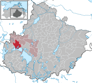
| Location of the municipality of Jabel in the Mecklenburg Lake District | ||
  |
||

Jabel is a municipality in the Mecklenburg Lake District in Mecklenburg-Western Pomerania, Germany. It is administered by the Lake Landscape Department in Waren , based in the city of Waren (Müritz) .
geography

The municipality of Jabel in the Mecklenburg Lake District is about ten kilometers from Waren (Müritz). The very wooded area around Jabel surrounds the Loppiner See and Jabelschen See , which are connected to the large lakes ( Kölpinsee and Fleesensee ). The Damerower Werder peninsula is located between Jabelschem and Kölpinsee - a special protected area in which bison have lived in an open-air enclosure since 1957 . The western part of the municipality is located in the Nossentiner / Schwinzer Heide nature park .
Jabel is surrounded by the neighboring communities of Klocksin in the north, Grabowhöfe in the northeast, Waren (Müritz) in the east, Klink in the southeast, Göhren-Lebbin in the south, Silz in the southwest, Nossentiner Hütte in the west and Hohen Wangelin in the northwest.
The districts of Damerow, Loppin and Neu Gaarz belong to Jabel .
history

In 1256, the originally Slavic settlement appeared for the first time as Jabele in a document. The name comes from the old Slavic jablŭ = apple tree . The village and church were looted and rebuilt twice during the Thirty Years War .
On November 1, 1806, Blücher's troops under Yorck lost a battle against France in the fourth coalition war in the forest between Jabel and Nossentin . The place is still called the battlefield today. A memorial there commemorates the fighting. In 1859 the village church was rebuilt after a fire. The pastor here was, among other things, the uncle of the important Low German writer Fritz Reuter , who described Jabel as “lying in paradise”.
Fritz Reuter was transferred to the seclusion of this paradise by his family. He was supposed to get away from his lifestyle, which after inefficient law studies, active fraternity and subsequent imprisonment, had to be visually described as "wet and happy". However, the project was relatively unsuccessful. Some of his stories - u. a. “De Köster up de Kindelbiehr” from “Läuschen und Rimels” - give an insight into the exuberant life that he is said to have led here with the farmers. Nobody knows exactly what this is poetry and truth, but it is documented that the poet spent the summer of 1841 in the village.
During the GDR era, a children's holiday camp was set up and maintained between Jabel and Plau am See and at the same time a training center for state forestry .
Due to the abundance of forests and water, Jabel has long since developed into a resort with holiday complex, campsites, restaurants and a marina .
On July 1, 1950, the previously independent communities of Damerow and Loppin were incorporated. On January 1, 2015, the neighboring community of Neu Gaarz was incorporated.
politics
coat of arms
|
|
Blazon : “Above a blue shield base, in it three golden wavy threads, split; in front, in gold, a silver-horned black bison head erupting from the right side edge, turned to the left; behind in gold half a green-leaved red apple tree at the crack with three red fruits. "
The coat of arms and the flag were designed by Michael Rohde from Schlockow . It was approved together with the flag on October 6, 2009 by the Ministry of the Interior and registered under the number 329 of the coat of arms of the state of Mecklenburg-Western Pomerania. |
|
Reasons for the coat of arms: In the coat of arms the apple tree stands as a symbol for the place name (jablŭ = apple tree), which comes from Old Slavonic. The number of apples should refer to the three districts. While the bison head symbolizes the bison herd that has been living in the open-air enclosure on the Damerower Werder peninsula since 1957, the wave threads are intended to indicate the location of the community on Jabelschen See, Kölpinsee and Loppiner See.
It should be noted about this coat of arms depiction that it does not entirely correspond to the heraldic design principles. According to the color rules, the fields created by the split in front and behind should have two different tinctures. |
flag
The flag is striped lengthways in yellow, red and yellow. The yellow stripes each take up one fifth, the red stripe three fifths the height of the flag cloth. In the middle of the red stripe is the municipal coat of arms, which is half the height of the flag. The relation of the height of the flag cloth to the length is like 3: 5.
Official seal
The official seal shows the municipal coat of arms with the inscription "GEMEINDE JABEL • LANDKREIS MECKLENBURGISCHE SEENPLATTE".
Attractions

- The village church in Jabel was built in 1868 on the foundations of the burnt down medieval church.
- The rectory opposite the church was built in its current form in 1824. In the rectory there is a 300 year old yew tree and huge winter linden trees .
- Wisent enclosure on the Damerower Werder
- Baroque , heavily rebuilt, two-storey, 10-axis Neu Gaarz manor house from around 1760
Infrastructure
Jabel is on the connection road from Malchow to Waren (Müritz) , which leads north around the large lakes (Fleesensee and Kölpinsee). The Jabel station, about a kilometer outside, is on the railway line - formerly " Mecklenburgische Südbahn " - from Waren (Müritz) via Malchow and Lübz to Parchim .
Web links
Individual evidence
- ↑ Statistisches Amt MV - population status of the districts, offices and municipalities 2019 (XLS file) (official population figures in the update of the 2011 census) ( help ).
- ^ The Slavic place names in Meklenburg in the year books of the Association for Mecklenburg History and Archeology . - Vol. 46 (1881), p. 60
- ↑ a b c Berthold Güssmer, Leipzig
- ↑ Hans-Heinz Schütt: On shield and flag production office TINUS, Schwerin 2011, ISBN 978-3-9814380-0-0 , p. 313/314.
- ↑ a b main statute § 2 (PDF).
Alt Schwerin | Altenhagen | Altenhof | Altentreptow | Ankershagen | Bartow | Basedow | Beggerow | Ownership | Blankenhof | Blankensee | Flower wood | Bollewick | Borrentine | Bredenfelde | Breesen | Breest | Briggow | Brunn | Buchholz | Stargard Castle | Burow | Bütow | Carpin | Cölpin | Dargun | Datzetal | Demmin | Eldetal | Rotten rust | Feldberger Seenlandschaft | Fincken | Friedland | Five lakes | Galenbeck | Gielow | Gnevkow | Godendorf | Goehren-Lebbin | Golchen | Gotthun | Grabowhöfe | Grammentin | Grapzow | Grischow | Large trowel | Groß Miltzow | Gross Nemerow | Large plastic | Groß Teetzleben | Grünow | Validity | Gülzow | High Wangelin | Hohenbollentin | Hohenmocker | Hohenzieritz | Holldorf | Ivenack | Jabel | Jürgenstorf | Kargow | Kentzlin | Kieve | Kittendorf | Little Thank You | Kletzin | Klink | Klocksin | Knorrendorf | Kratzeburg | Kriesow | Sublank | Kuckssee | Kummerow | Larz | Leizen | Lindenberg | Lindetal | Malchin | Malchow | Meesiger | Melz | Mirow | Möllenbeck | Möllenhagen | Mölln | Moltzow | Neddemin | Neetzka | Neubrandenburg | Neuenkirchen | Recalculation | Neustrelitz | Neverin | Nossendorf | Nossentiner Hut | Peenehagen | Penkow | Penzlin | Pragsdorf | Priborn | Priepert | Pripsleben | Rechlin | Ritzerow | Röbel / Müritz | Röckwitz | Rosenow | Sarov | Schloen-Dratow | Schönbeck | Schönfeld | Schönhausen | Black | Siedenbollentin | Siedenbrünzow | Sietow | Silz | Sommersdorf | Sponholz | Staven | Stavenhagen | Steer | Südmüritz | Torgelow am See | Trollenhagen | Tützpatz | Userin | Utzedel | Forgive | Voigtsdorf | Vollrathsruhe | Walow | Waren (Müritz) | Warrenzin | Werder | Wesenberg | Wildberg | Woggersin | Wokuhl-Dabelow | Wolde | Woldegk | Wulkenzin | Wustrow | Zettemin | Zirzow | Zislow