
Ankershagen
| coat of arms | Germany map | |
|---|---|---|

|
Coordinates: 53 ° 29 ' N , 12 ° 58' E |
|
| Basic data | ||
| State : | Mecklenburg-Western Pomerania | |
| County : | Mecklenburg Lake District | |
| Office : | Penzliner Land | |
| Height : | 58 m above sea level NHN | |
| Area : | 28.19 km 2 | |
| Residents: | 515 (Dec. 31, 2019) | |
| Population density : | 18 inhabitants per km 2 | |
| Postal code : | 17219 | |
| Area code : | 039921 | |
| License plate : | MSE, AT, DM, MC, MST, MÜR, NZ, RM, WRN | |
| Community key : | 13 0 71 005 | |
| LOCODE : | DE 5AR | |
| Office administration address: | Warener Chaussee 55a 17217 Penzlin |
|
| Website : | ||
| Mayor : | Thomas Will | |
| Location of the municipality Ankershagen in the Mecklenburg Lake District | ||
  |
||

Ankershagen is a municipality in the Mecklenburg Lake District in Mecklenburg-Western Pomerania on the northern edge of the Müritz National Park .
The municipality is administered by the Penzliner Land Office , based in the city of Penzlin . Since July 25, 2010 the place has been officially called "Schliemanngemeinde Ankershagen".
geography
Ankershagen is located directly at the Müritz National Park on a glacial terminal moraine ridge in an east-west direction, which forms the watershed between the waters flowing into the Baltic Sea and the North Sea : the streams flow north into the Baltic Sea and south into the North Sea ( Havel / Elbe ).

The Havel rises not far from Ankershagen and then flows more than 300 kilometers until it reaches the Elbe. Strictly speaking, the Havel rises in the three source lakes Born , Trinnen and Mühlensee , which used to be part of a much larger Ice Age Rinnensee , the southern end of which can be found at the Narrow area at Granzin (Slavic border), i.e. with the Käbelicksee includes. In order to operate a mill, monks probably already pierced the eastern edge of the Mühlensee in the early Middle Ages , which thus drains into the Baltic Sea. To get pressure for the mill, they dammed the mill lake in the south with a dam that is still clearly visible today. Since this is on marshy ground, the seal was not completely successful. The water that gushes from the masonry Havel spring today seeps from the southern end of the Mühlensee under this dam. So this drains in the Baltic and North Sea. The edges of this Rinnensee are lined with numerous hills up to 38 meters above sea level, all of which lie in the forest and are comparatively flat at the top. The northernmost is the Warensberg (102.2 m above sea level ), the name of which is derived from Germanic times - either from the god Wotan or the tribe of the Warnen . East of the Mühlensee one of these hills in the forest even has a (probably modern - it is just too well preserved) quadrangular hill . On the other hand, none of the other hills that the farmers use as arable land and pastures are flattened, not even the one on which the king's cradle lies.
Districts
The districts Ankershagen, Bocksee, Bornhof, Friedrichsfelde and Rumpshagen belong to Ankershagen.
history
Megalithic graves and graves from the Bronze Age testify to the 3rd millennium BC. The presence of people. Between Bornhof and Bocksee there is a collection of burial mounds . A particularly prominent barrow, called Königswiege , is located about 500 meters south of Friedrichsfelde. According to legend, a long time ago a king had his favorite daughter buried here in a golden cradle.
Ankershagen was first mentioned in a document in 1252. The ruins of the medieval Ankershagen Castle and the manor house next to it were the seat of the von Holstein family for centuries . The place was part of the (Grand) Duchy of Mecklenburg-Schwerin . The defensive wall was partially renewed in 1997. In 1980 the Heinrich Schliemann Museum was set up in the former rectory, where Schliemann had a formative childhood.
Bornhof was first mentioned at the beginning of the 18th century when a dairy was established.
Rumpshagen: The estate owners were the von Voss and von Gundlach families . The renovated baroque manor house Rumpshagen dates from 1732. After 1945 the manor house was used for residential purposes and as the seat of the municipal administration; it was privatized and renovated after 2000.
politics
coat of arms
|
|
Blazon : "A blue wavy strip in gold, accompanied: above by five (2: 3) green oak leaves, below by a red triangular shield with a golden anchor inside."
The coat of arms and the flag were designed by the Schwerin heraldist Heinz Kippnick . It was approved together with the flag on June 11, 2002 by the Ministry of the Interior and registered under the number 263 of the coat of arms of the state of Mecklenburg-Western Pomerania. |
| Justification for the coat of arms: In the coat of arms, the symbolism with the wavy bar refers to the nearby Havel spring lakes and with the acorn leaves to the extensive forest in the area. The anchor, the 1342 verifiable seal image of those from the anchor, is intended to commemorate the alleged founder of the place of the same name. |
flag
The flag is striped in yellow, green and yellow across the longitudinal axis of the flag cloth. The yellow stripes each take up a quarter, the green stripe takes up half the length of the flag cloth. In the middle of the flag, two thirds of the height of the flag, is the municipal coat of arms. The length of the flag is related to the height as 5: 3.
Official seal
The official seal shows the municipal coat of arms with the inscription "SCHLIEMANNGEMEINDE ANKERSHAGEN • LANDKREIS MECKLENBURGISCHE SEENPLATTE".
Attractions
→ See also the list of architectural monuments in Ankershagen
- The memory of the discoverer of Troy has been kept in the Heinrich Schliemann Museum since 1980 . For children, a play device in the form of a Trojan horse was set up in front of the museum set up in the former rectory, Schliemann's parents' house .
- One of the largest ash trees in Mecklenburg-Western Pomerania stands in front of the museum, with the museum's farm building to the right.
- The Ankershagen Church is an early Gothic stone church with molded parts made of brick . The square choir has a dome-shaped ribbed vault. The ship was converted into a two-nave hall church with four bays early on. The ribbed vault rests on three square pillars. The windows are only preserved in their original form in the east wall. They are narrow, with round arches and ogival panels. The tower has an eight - sided half - timbered tower . Decorative friezes are in the nave and choir. The interior furnishings include a wooden baptism from 1618 with fittings. A life-size crucifix , the body of which dates from the 15th century, hangs on the wall above .
- Two-storey, eleven- axis Rumpshagen manor house with a gabled central risalit and mansard roof ; Special feature: decorative broken glass in the plaster; after 1945 apartments and community rooms, today a well-renovated house.
- Small village church in Rumpshagen from 1779 made of field and brick.
- Information point at the entrance to the Müritz National Park in Friedrichsfelde

Trojan horse at the museum

Heinrich Schliemann Museum, formerly a rectory
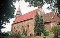
Ankershagen village church
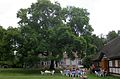
Ash in Ankershagen
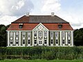
Manor house in Rumpshagen
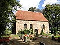
Church in Rumpshagen


Personalities
- Otto Held (1818–1897), manor owner and member of parliament, was born in Ankershagen.
- Heinrich Schliemann (1822–1890), spent his childhood in Ankershagen.
- Johann Heinrich Voß (1751–1826), worked from 1769 to 1772 as a private tutor in Ankershagen.
Web links
Individual evidence
- ↑ Statistisches Amt MV - population status of the districts, offices and municipalities 2019 (XLS file) (official population figures in the update of the 2011 census) ( help ).
- ^ Hans-Heinz Schütt: On shield and flag production office TINUS, Schwerin 2011, ISBN 978-3-9814380-0-0 , p. 310/311.
- ↑ a b main statute § 1 (PDF).
Alt Schwerin | Altenhagen | Altenhof | Altentreptow | Ankershagen | Bartow | Basedow | Beggerow | Ownership | Blankenhof | Blankensee | Flower wood | Bollewick | Borrentine | Bredenfelde | Breesen | Breest | Briggow | Brunn | Buchholz | Stargard Castle | Burow | Bütow | Carpin | Cölpin | Dargun | Datzetal | Demmin | Eldetal | Rotten rust | Feldberger Seenlandschaft | Fincken | Friedland | Five lakes | Galenbeck | Gielow | Gnevkow | Godendorf | Goehren-Lebbin | Golchen | Gotthun | Grabowhöfe | Grammentin | Grapzow | Grischow | Large trowel | Groß Miltzow | Gross Nemerow | Large plastic | Groß Teetzleben | Grünow | Validity | Gülzow | High Wangelin | Hohenbollentin | Hohenmocker | Hohenzieritz | Holldorf | Ivenack | Jabel | Jürgenstorf | Kargow | Kentzlin | Kieve | Kittendorf | Little Thank You | Kletzin | Klink | Klocksin | Knorrendorf | Kratzeburg | Kriesow | Sublank | Kuckssee | Kummerow | Larz | Leizen | Lindenberg | Lindetal | Malchin | Malchow | Meesiger | Melz | Mirow | Möllenbeck | Möllenhagen | Mölln | Moltzow | Neddemin | Neetzka | Neubrandenburg | Neuenkirchen | Recalculation | Neustrelitz | Neverin | Nossendorf | Nossentiner Hut | Peenehagen | Penkow | Penzlin | Pragsdorf | Priborn | Priepert | Pripsleben | Rechlin | Ritzerow | Röbel / Müritz | Röckwitz | Rosenow | Sarov | Schloen-Dratow | Schönbeck | Schönfeld | Schönhausen | Black | Siedenbollentin | Siedenbrünzow | Sietow | Silz | Sommersdorf | Sponholz | Staven | Stavenhagen | Steer | Südmüritz | Torgelow am See | Trollenhagen | Tützpatz | Userin | Utzedel | Forgive | Voigtsdorf | Vollrathsruhe | Walow | Waren (Müritz) | Warrenzin | Werder | Wesenberg | Wildberg | Woggersin | Wokuhl-Dabelow | Wolde | Woldegk | Wulkenzin | Wustrow | Zettemin | Zirzow | Zislow