
Schloen-Dratow
| coat of arms | Germany map | |
|---|---|---|

|
Coordinates: 53 ° 31 ' N , 12 ° 49' E |
|
| Basic data | ||
| State : | Mecklenburg-Western Pomerania | |
| County : | Mecklenburg Lake District | |
| Office : | Lake landscape goods | |
| Height : | 62 m above sea level NHN | |
| Area : | 36.38 km 2 | |
| Residents: | 865 (Dec. 31, 2019) | |
| Population density : | 24 inhabitants per km 2 | |
| Postcodes : | 17192 (Groß Dratow, Neu Schloen, Schloen) , 17219 (Klockow) |
|
| Area code : | 039934 | |
| License plate : | MSE, AT, DM, MC, MST, MÜR, NZ, RM, WRN | |
| Community key : | 13 0 71 174 | |
| Office administration address: | Friedensstrasse 11 17192 Waren (Müritz) |
|
| Website : | ||
| Mayor : | Berthold Schulz | |
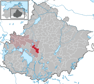
| Location of the community Schloen-Dratow in the Mecklenburg Lake District | ||
  |
||

Schloen-Dratow is a municipality in the Mecklenburg Lake District in Mecklenburg-Western Pomerania . It is administered by the Lake Landscape Department in Waren , based in the city of Waren (Müritz) .
geography
The community borders on Peenehagen , Groß Plasten , Möllenhagen , Ankershagen , Kratzeburg , Kargow and Torgelow am See .
The Ostpeene rises in the southwest of the municipality , the longest but not hydrographically highest-ranking of the three source rivers of the Peene .
Districts
Districts are Groß Dratow , Klein Dratow , Klockow , Neu Schloen , Oberschloen , Schloen , Schloener Kolonie and Schwastorf .
In postal terms, the municipality is divided into the following places:
- 17192 Groß Dratow (with the districts of Klein Dratow, Klockow and Schwastorf)
- 17192 New Castle
- 17192 Castle
- 17219 Klockow
history
Schloen-Dratow was created on January 1, 2012 from the merger of the previously independent communities Groß Dratow and Schloen . As of January 1, 2014, the Dratow-Schloen community was renamed Schloen-Dratow.
Groß Dratow was first mentioned in a document in 1284. The church dates from the 13th century and the village smithy from 1860.
Schloen was first mentioned in a document in 1218. The church from the beginning of the 13th century stands on the site of a former hill fort. Its tower dates from 1765.
Schwastorf: Landowners were u. a. the families von Schuckmann (around 1803–1869), Sauerkohl (until 1886), Dähnert (until 1896), Walter-Sürssen (until 1928) and Freiherr von dem Knesebeck - Milendonck (until 1945). The manor house from the middle of the 18th century was after 1945 a. a. Culture house and is now a ruin.
politics
Coat of arms, flag, official seal
The municipality has no officially approved national emblem, neither a coat of arms nor a flag. The official seal is the small state seal with the coat of arms of the state of Mecklenburg. It shows a looking bull's head with a torn neck fur and a crown and the inscription "GEMEINDE SCHLOEN-DRATOW • LANDKREIS MECKLENBURGISCHE SEENPLATTE".
Attractions
- Schloener church , the core from the 13th century, with an altar from the 18th century based on Italian models
- Castle watermill
- Village forge in Groß Dratow from 1860; today restaurant
- Village church in Groß Dratow (13th century)
- Neo-Gothic cemetery chapel (built around 1900) in Schwastorf
- Manor house and storage ruin in Schwastorf
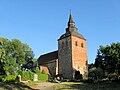
Church in Schloen

Church in Gross Dratow

Cemetery chapel in Schwastorf

Ruins of the manor house in Schwastorf


Infrastructure
Schloen-Dratow is on the federal highway 192 from Waren (Müritz) to Neubrandenburg .
The municipality is served today by bus lines of the Mecklenburg-Western Pomerania Transport Company (MVVG). The nearest train station is in the town of Waren (Müritz) ( Neustrelitz – Warnemünde line ). The Klockow station (near Waren / Müritz) was also on the Neustrelitz – Warnemünde railway line; however, as a result of the expansion of the line, no passenger trains have stopped there since September 2011. The former Schwastorf-Dratow stop and the relevant Kargow - Möllenhagen section of the Parchim – Neubrandenburg railway line have not been used for passenger transport since 1970.
Web links
Individual evidence
- ↑ Statistisches Amt MV - population status of the districts, offices and municipalities 2019 (XLS file) (official population figures in the update of the 2011 census) ( help ).
- ↑ Mecklenburg-Western Pomerania Statistical Office - Area changes in Mecklenburg-Western Pomerania January 1 to January 10, 2012 (PDF, 53 kB)
- ↑ Statistics MV ( Memento from February 22, 2014 in the Internet Archive )
- ↑ Main Statute, Section 2, Paragraph 1
Alt Schwerin | Altenhagen | Altenhof | Altentreptow | Ankershagen | Bartow | Basedow | Beggerow | Ownership | Blankenhof | Blankensee | Flower wood | Bollewick | Borrentine | Bredenfelde | Breesen | Breest | Briggow | Brunn | Buchholz | Stargard Castle | Burow | Bütow | Carpin | Cölpin | Dargun | Datzetal | Demmin | Eldetal | Rotten rust | Feldberger Seenlandschaft | Fincken | Friedland | Five lakes | Galenbeck | Gielow | Gnevkow | Godendorf | Goehren-Lebbin | Golchen | Gotthun | Grabowhöfe | Grammentin | Grapzow | Grischow | Large trowel | Groß Miltzow | Gross Nemerow | Large plastic | Groß Teetzleben | Grünow | Validity | Gülzow | High Wangelin | Hohenbollentin | Hohenmocker | Hohenzieritz | Holldorf | Ivenack | Jabel | Jürgenstorf | Kargow | Kentzlin | Kieve | Kittendorf | Little Thank You | Kletzin | Klink | Klocksin | Knorrendorf | Kratzeburg | Kriesow | Sublank | Kuckssee | Kummerow | Larz | Leizen | Lindenberg | Lindetal | Malchin | Malchow | Meesiger | Melz | Mirow | Möllenbeck | Möllenhagen | Mölln | Moltzow | Neddemin | Neetzka | Neubrandenburg | Neuenkirchen | Recalculation | Neustrelitz | Neverin | Nossendorf | Nossentiner Hut | Peenehagen | Penkow | Penzlin | Pragsdorf | Priborn | Priepert | Pripsleben | Rechlin | Ritzerow | Röbel / Müritz | Röckwitz | Rosenow | Sarov | Schloen-Dratow | Schönbeck | Schönfeld | Schönhausen | Black | Siedenbollentin | Siedenbrünzow | Sietow | Silz | Sommersdorf | Sponholz | Staven | Stavenhagen | Steer | Südmüritz | Torgelow am See | Trollenhagen | Tützpatz | Userin | Utzedel | Forgive | Voigtsdorf | Vollrathsruhe | Walow | Waren (Müritz) | Warrenzin | Werder | Wesenberg | Wildberg | Woggersin | Wokuhl-Dabelow | Wolde | Woldegk | Wulkenzin | Wustrow | Zettemin | Zirzow | Zislow