
Friedland (Mecklenburg)
| coat of arms | Germany map | |
|---|---|---|

|
Coordinates: 53 ° 40 ' N , 13 ° 33' E |
|
| Basic data | ||
| State : | Mecklenburg-Western Pomerania | |
| County : | Mecklenburg Lake District | |
| Office : | Friedland | |
| Height : | 15 m above sea level NHN | |
| Area : | 141.73 km 2 | |
| Residents: | 6456 (Dec. 31, 2019) | |
| Population density : | 46 inhabitants per km 2 | |
| Postal code : | 17098 | |
| Primaries : | 039601, 039606, 03968 | |
| License plate : | MSE, AT, DM, MC, MST, MÜR, NZ, RM, WRN | |
| Community key : | 13 0 71 035 | |
| City structure: | 13 districts | |
City administration address : |
Riemannstrasse 42 17098 Friedland |
|
| Website : | ||
| Mayor : | Wilfried Block | |
| Location of the city of Friedland in the Mecklenburg Lake District | ||
  |
||

Friedland is a small town in the eastern part of the Mecklenburg Lake District in eastern Mecklenburg-Western Pomerania . Historically, it belongs to the state of Mecklenburg . The city, which has been an official part of the city since January 1, 2004, is the seat of the Friedland Office , to which two other municipalities belong. The place is a basic center near the regional center Neubrandenburg .
geography
Geographical location
Friedland an der Datze is roughly halfway between the cities of Neubrandenburg and Anklam and northwest of the Brohmer Mountains . The Friedländer Große Wiese, named after her, extends east of the city . The Friedländer Mühlenteich is located southwest of the city .
City structure
The following districts belong to the city of Friedland
history
Friedland


Even before 1200, a settlement of the traders who already owned a Nikolaikirche was built at a crossroads of old trade routes on the edge of the large fens on a ridge. When the Stargard rule came into the hands of the Brandenburgers after the Treaty of Kremmen , the Brandenburg margraves Otto III founded. and Johann I. next to the existing settlements in 1244 under German law the city of Vredeland , today's Friedland. The two donors can still be found in the city arms today. The place, directly on the ditch near the Pomeranian border, served as protection against the Pomeranians .
Around 1300 a grid-shaped street grid developed in an elliptical city plan, which was surrounded by a partially preserved, strong fortification with a city wall up to six meters high. The Gothic Anklamer Tor (Steintor) began in 1304, while the late Gothic, three-story ( Neubrandenburger Tor ) (formerly Burgtor) was built in the 15th century. Later 29 Wieck houses were added to the city wall ; The fishing castle from the 13th century was preserved. The fishing tower of the fortification became a water tower in 1911 and a lookout tower in 1997.
Through the Treaty of Vietmannsdorf in 1304, the Stargard rule and with it Friedland came under the rule of the lords, dukes, and finally the grand dukes of Mecklenburg. Friedland became a country town in Mecklenburg and, as such, part of the towns in the knightly district of Stargard , which were represented on the Mecklenburg regional parliaments of the estates united in 1523 until 1918 .
Wars like the Seven Years' War (battle near Kavelpass , 1760), famines, epidemics (1637/38 with 872 plague deaths), city fires (twelve, especially the great city fire of 1703) as well as the situation in one of the structurally weakest German regions hampered urban development. In 1806 Napoleon's troops under Marshal Joachim Murat marched through the city with 70,000 soldiers, then further French (over 190,000 men) and Prussian troops. Friederike Krüger from Friedland fought in men's clothing in the Napoleonic Wars of Liberation (1813-1815) to liberate her country. For her bravery she even received the Iron Cross under the name August Lübeck .

,_Mecklenburg-Vorpommern_-_Marktplatz_(Zeno_Ansichtskarten).jpg)
,_Mecklenburg-Vorpommern_-_Kaiserstra%C3%9Fe_(Zeno_Ansichtskarten).jpg)
Like many other cities, Friedland experienced a heyday in the 19th century. In 1803 a new town hall was built, in 1862 a hospital in the Johannesstift, from 1866 a modern water supply system with hydroelectric power station (1886) on Woldegker Straße. The Friedländer Gymnasium (1371 to 1840 school for scholars ) was the most important secondary school in southeast Mecklenburg until the early 19th century. The first German gymnastics club was founded in Friedland in 1814 (today: TSV 1814 Friedland ), making it the oldest sports club in Germany. Carl Leuschner, teacher and most recently vice-principal of the school of scholars, laid the first gymnastics course in Mecklenburg in Friedland in 1814. From 1854 Friedland had street lights and from 1894 sidewalks. The city became famous for the Rote Friedländerin , a red tile that was used for laboratory tables and kitchen tiles.
During the founding period , the Neubrandenburg – Friedland railway line (1884), the dairy (1890), the sugar factory (1891), the mosaic slab factory (1894), the gas factory (1896) and the overland control center (1911) were built.
At the end of the Second World War on 28./29. April 1945 large parts of the old town, including the town hall from 1803, destroyed or burned down by Red Army soldiers. New buildings erected in the old town area since 1965 characterize the cityscape today. From 1965 to 1985, 1,334 apartments were built in the city center, mostly using prefabricated panels. After the political change, the still existing historical buildings in the old town were renovated as part of urban development funding.
From 1952 to 1994 Friedland belonged to the district of Neubrandenburg-Land (until 1990 in the GDR district of Neubrandenburg , from 1990 to 1994 in the state of Mecklenburg-Western Pomerania ). In 1994 the city was incorporated into the Mecklenburg-Strelitz district. Since the district reform in 2011 , it has been in the Mecklenburg Lake District .
Districts
Eichhorst was first mentioned in 1298 as Eykchorst . The Angerdorf built the Gothic stone church around 1300 on the Anger ; In 1836/37 it was expanded and the octagonal lattice tower was built according to plans by Buttel . The estate often had changing owners, was relocated after 1945, was run as LPGs in 1952 and was an agricultural cooperative after 1990. The manor house from 1821 was used as a ten-class school building from 1964 until the 1990s.
Glienke was first mentioned in 1298. A Slavic rampart dates from the 10th century. The stone church of the round village on the Anger was built by 1772.
Jatzke , an anger village with a former estate (the manor house burned down in 1945), has the remains of a Slavic fortification.
Liepen had been a district of Eichhorst since 1973. The national economist Johann Heinrich von Thünen ran the estate for several years around 1806.
Ramelow: The estate was owned by the von Hahn families (from 1769), Heinrich Hase (from 1815), Johann Emanuel Hoth (from 1821) and Ludwig Bicker (1895–1945). The manor house from the time after 1769 is falling into disrepair.
Schwanbeck was first mentioned in 1317 as Swanebeke .
Incorporations
Bresewitz was incorporated on January 1, 1957. Brohm and Schwanbeck have been part of Friedland since June 13, 2004.
On May 25, 2014, the communities Glienke and Eichhorst were incorporated into the city of Friedland. On May 26, 2019, the municipality of Genzkow, southwest of Friedland, was incorporated into the city of Friedland.
population
|
|
from 1990: as of December 31 of the respective year
politics
City council
Since the local elections on May 26, 2019, the Friedland city council has been composed as follows:
| Party / list | Seats |
|---|---|
| CDU | 7th |
| Friedland Free Community of Voters | 3 |
| AfD | 3 |
| Friedland women's list | 3 |
| The left | 3 |
| SPD | 1 |
| All in all | 20th |
mayor
- since 1992: Wilfried Block (independent)
Block was confirmed in the mayoral election on April 1, 2012 with 82.3% of the valid votes for a further term of nine years in his office.
coat of arms
|
|
Blazon : “In silver, a double red wall arch that ends at the intersection below in a fallen heraldic lily, with three red towers, the middle one with a five-way tinned plate supported by struts, the lower side towers each with a four-way tinned plate and a window ; underneath are the busts of two blue armor with gold helmet clasp and gold belt, who has a silver sword with a gold handle in his right hand and a gold lance with a silver tip in his left hand, and who has a silver sword with a gold tip in his right hand Grip and in the left hand a golden flag lance with a silver tip and a cross-striped red-silver flag, between the armor a silver triangular shield with a red eagle inside. "
The coat of arms was redrawn in 1997 and registered under number 129 of the coat of arms of the state of Mecklenburg-Western Pomerania. |
| Justification of the coat of arms: The coat of arms is based on the seal image of SIGILLVM BVRGENSIVM DE FRIDELAN - first handed down as an imprint in 1343. On September 30, 1939 Friedland was awarded a coat of arms slightly modified by the Berlin-based Prof. Hans Herbert Schweitzer by the Reich governor in Mecklenburg : three tinned red towers in gold standing on a double arch, a silver shield with a red eagle under them and between the busts of the armored men . The restored coat of arms shows an urban symbol, the wall arch with the three towers, as a symbol for a fortified city, as well as a rulership symbol, the coat of arms of the margraves of Brandenburg, and two human figures symbolizing the two margravial city founders. |
flag
The flag was designed by Frank Erstling from Friedland and approved on July 15, 1997 by the Ministry of the Interior.
The flag is evenly striped lengthways in red and white. In the middle of the flag is the city coat of arms, two thirds of the height of the red and white stripes. The length of the flag is related to the height as 5: 3.
Official seal
The official seal shows the city arms with the inscription STADT FRIEDLAND - LANDKREIS MECKLENBURGISCHE SEENPLATTE.
Partnerships
International Friedland meetings have been held since 1996 under the motto "Friedland - Peaceful Land - Peaceful Europe". Participants are eight places that bear the name Friedland or had in the past. In addition to Friedland in Mecklenburg-Western Pomerania, Friedland (Niederlausitz) (Brandenburg), Friedland (Lower Saxony) , Frýdlant v Čechách (Czech Republic), Frýdlant nad Ostravicí (Czech Republic), Korfantów (Poland), Mieroszów (Poland) and Prawdinsk (Russia) belong to it.
Attractions


- Brick Gothic parish church of St. Mary , from 14./15. Century as a three-aisled hall church with eleven bays . The church was badly damaged by the fire in 1703. In the 19th century, the tower, visible from afar, was raised to a height of 91 meters.
- Large organ work by Wilhelm Sauer from 1905 in the baroque prospectus from 1744.
- Parish church Sankt Nikolai, from the second half of the 13th century, Gothic stone block construction, burned down to the surrounding walls in 1945 and has been in ruins since then.
- City fortifications from after 1304; it consists of
- the city wall made of field stone, up to six meters high,
- the Wiekhaus Fischerburg (15th century) (originally there were 29 Wiekhäuser),
- the outer moat system (formerly divided into three parts, today partly green areas),
- the Anklamer Tor (formerly stone gate) made of field stones (substructure) and bricks with round towers on both sides (14th century),
- the Neubrandenburger Tor , uniform three-storey brick building with city and field side gables (second half of the 15th century),
- the round Fangelturm brick (14th c.), partially destroyed during a siege by troops Pomeranian 1453, 1909-1911 converted into a water tower,
- the former water mill from 1703 on the Datze river
- Remains of an old cemetery on the city ramparts, on it (changed location) only the tomb of Heinrich Arminius Riemann ; He is also remembered in the memorial stone north of St. Mary's Church and a plaque on the site of his former home (loss of war).
- City museum in the restored half-timbered building Mühlenstrasse 1 with an exhibition and original vehicles of the Mecklenburg-Pomerania Narrow Gauge Railway (MPSB).
- Former old grammar school , Rudolf-Breitscheid-Straße, classicist school building from 1784 with the remains of the wall from a previous medieval building
- Newly designed market with the outline of the town hall destroyed in 1945
- Memorial stone from the 1950s to the left of Anklamer Tor , between the city wall and the first wall crown, for the victims of National Socialism: six concentration camp victims and two deserters
- Memorial stone from 1965 on Pasewalker Straße in front of the confluence with the New Cemetery in memory of two young Wehrmacht soldiers who deserted at the end of the war and were shot or hanged by SS men
- Memorial stone from 1970 at the Neubrandenburg Gate for two Soviet soldiers who were shot in 1945; Meant for parliamentarians in GDR times , but actually educators . Since this fact became known, the stone has been in the museum courtyard

city Museum

Half-timbered house on the market

Fishing tower

Wiekhaus fishing castle

Detail at the Anklamer Tor
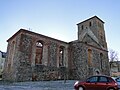
St. Nikolai - ruin

St. Nikolai with tower and horse market around 1900

Monument 1870/71

Monument 1914/18 by Dammann

Jahndenkmal 1922


_Denkmal_1870-71.jpg)


- Districts
- Brohm village church (field stone church from the 13th century with baroque interior design)
- Cosa Manor: 1846–1945 owned by the von Oertzen family
- Eichhorst manor from 1821 (decayed), owned by the von Bredow family , from 1823 by Engel, from 1928 by the Count of Schwerin
- Gothic stone church in Eichhorst from around 1300, alterations in 1836/37 and a new tower
- Field stone church in Glienke from 1772
- Field stone church in Jatzke
- Brick church in Liepen

Cosa manor

Eichhorst manor

Glienke Church

Liepen Church


traffic
Friedland is on the federal highway B 197 between Neubrandenburg and Anklam and on the state roads L 28 between Neddemin and Ferdinandshof , L 273 to Altentreptow and L 281 to Woldegk . The closest motorway junctions are Neubrandenburg-Ost and Friedland i. M. on the A 20 (Neubrandenburg - Uckermark triangle ).
The city has no rail connection. The station Friedland (Meckl) was due to the Mecklenburg-Pomeranian narrow-gauge railway between Jarmen and Ferdinandshof on which the passenger was discontinued in 1945 or 1969, at the railway Neubrandenburg-Friedland (1994 end of passenger traffic).
Personalities
sons and daughters of the town
- Andreas Helvigius (1572–1643), philologist, educator
- Ludwig Gerhard (around 1680 - 1738), Lutheran theologian and teacher
- Johann Gottlieb Rudolphi (1760–1838), pastor of the parish church of St. Marien (Friedland) and Mecklenburg historical researcher
- Friederike Krüger (1789–1848), participant in the Wars of Liberation
- Johann Carl Heinrichs (1793–1855), theologian, vice rector of the school of scholars and pastor at the Nikolaikirche
- Carl Uterhart (1793-1852), doctor
- Johann Friedrich Gentzen (1796–1871), fraternity member and librarian
- Franz Biese (1803–1895), philologist, Aristotle researcher
- Adolph Goeden (1810–1888), doctor, member of the Frankfurt National Assembly
- Emilie Mayer (1812–1883), composer
- Robert Praefcke (1831–1910), administrative lawyer and insurance director
- Rudolf Berlin (1833–1897), ophthalmologist
- Gustav Langbein (1833–1915), Lutheran clergyman
- Heinrich Bossart (1857–1930), lawyer, Minister of State in Mecklenburg-Strelitz
- Ludwig Sternberg (1857–1935), actor and Fritz Reuter reciter
- Paul Dörwald (1859–1937), philologist and grammar school director
- Willi Köhn (1900–1962), Consul General and SS Brigade Leader
- Lilly Kühnel (* 1953), politician (SPD), 2002–2006 member of the state parliament in Mecklenburg-Western Pomerania
- Dirk Barsikow (* 1962), football player
Personalities associated with Friedland

- Johann Heinrich von Thünen (1783–1850), agricultural and economic scientist, headed the Liepen estate around 1806 for several years
- Carl Leuschner (1787–1861), theologian, teacher and vice principal of the school of scholars, founder of gymnastics in Friedland
- Karl Bülch (1792–1844), teacher and sub-rector of the school of scholars
- Heinrich (Arminius) Riemann (1793–1872), teacher at the school of scholars, then pastor at St. Marien
- Karl Horn (1794–1879), teacher and prorector of the school of scholars, co-founder of the German fraternity
- Wilhelm Langbein (1801–1840), teacher, vice-principal of the school of scholars
- Daniel Runge (1804–1864), theologian and parliamentarian, attended the scholars' school in Friedland
- August Dühr (1806–1896), classical philologist, from 1840 vice-rector, later vice-rector at the grammar school in Friedland
- Fritz Reuter (1810–1874), Low German poet, attended school in Friedland
- Adolph Runge (1816–1862), doctor in Friedland, member of the preliminary parliament of the Frankfurt National Assembly
- Ernst Boll (1817–1868), naturalist, private tutor in Friedland
- Wilhelm Sauer (1831–1916), organ builder, spent his youth in Friedland
- Marx Möller (1868–1921), writer, spent his youth in Friedland
Web links
- Literature about Friedland (Mecklenburg) in the state bibliography MV
- Ortschronik von Friedland , accessed January 31, 2018
Individual evidence
- ↑ Statistisches Amt MV - population status of the districts, offices and municipalities 2019 (XLS file) (official population figures in the update of the 2011 census) ( help ).
- ↑ Regional Spatial Development Program Mecklenburg Lake District (2011) , Regional Planning Association, accessed on July 12, 2015
- ↑ Main statute of the city of Friedland / Mecklenburg-Western Pomerania, § 1
- ↑ Landesportal MV: Friedland ( Memento of the original from November 9, 2013 in the Internet Archive ) Info: The archive link was inserted automatically and has not yet been checked. Please check the original and archive link according to the instructions and then remove this notice.
- ^ Sub- rector Karl Bülch , Leuschner's successor as gymnastics supervisor, later became the founder of gymnastics in Malchin with the experience he had gathered in Friedland .
- ↑ Municipalities 1994 and their changes since January 1, 1948 in the new federal states , Metzler-Poeschel publishing house, Stuttgart, 1995, ISBN 3-8246-0321-7 , publisher: Federal Statistical Office
- ^ StBA: Changes in the municipalities in Germany, see 2004
- ^ Statistical Office Mecklenburg-Western Pomerania: Area changes
- ↑ area changes and name approval , notice of the Ministry of Internal Affairs and Europe in the Official Journal of Mecklenburg-Vorpommern , no. 52/2018 of 24 December 2018 p 663
- ↑ Population development of the districts and municipalities in Mecklenburg-Western Pomerania (Statistical Report AI of the Statistical Office Mecklenburg-Western Pomerania)
- ^ Result of the election for the city council on May 26, 2019
- ^ Friedland - A city is fighting for more refugees. In: Die Welt , August 25, 2015.
- ↑ Main statute of the city of Friedland / Mecklenburg-Western Pomerania, § 7
- ^ Result of the mayoral election on April 1, 2012 In: Neue Friedländer Zeitung , April 11, 2012, p. 3
- ↑ Hans-Heinz Schütt: On shield and flag production office TINUS, Schwerin 2011, ISBN 978-3-9814380-0-0 , p. 295/296.
- ↑ a b main statute § 1 (PDF).
- ^ Partnerships ( memento of February 5, 2012 in the Internet Archive ) on friedland-mecklenburg.de
Alt Schwerin | Altenhagen | Altenhof | Altentreptow | Ankershagen | Bartow | Basedow | Beggerow | Ownership | Blankenhof | Blankensee | Flower wood | Bollewick | Borrentine | Bredenfelde | Breesen | Breest | Briggow | Brunn | Buchholz | Stargard Castle | Burow | Bütow | Carpin | Cölpin | Dargun | Datzetal | Demmin | Eldetal | Rotten rust | Feldberger Seenlandschaft | Fincken | Friedland | Five lakes | Galenbeck | Gielow | Gnevkow | Godendorf | Goehren-Lebbin | Golchen | Gotthun | Grabowhöfe | Grammentin | Grapzow | Grischow | Large trowel | Groß Miltzow | Gross Nemerow | Large plastic | Groß Teetzleben | Grünow | Validity | Gülzow | High Wangelin | Hohenbollentin | Hohenmocker | Hohenzieritz | Holldorf | Ivenack | Jabel | Jürgenstorf | Kargow | Kentzlin | Kieve | Kittendorf | Little Thank You | Kletzin | Klink | Klocksin | Knorrendorf | Kratzeburg | Kriesow | Sublank | Kuckssee | Kummerow | Larz | Leizen | Lindenberg | Lindetal | Malchin | Malchow | Meesiger | Melz | Mirow | Möllenbeck | Möllenhagen | Mölln | Moltzow | Neddemin | Neetzka | Neubrandenburg | Neuenkirchen | Recalculation | Neustrelitz | Neverin | Nossendorf | Nossentiner Hut | Peenehagen | Penkow | Penzlin | Pragsdorf | Priborn | Priepert | Pripsleben | Rechlin | Ritzerow | Röbel / Müritz | Röckwitz | Rosenow | Sarov | Schloen-Dratow | Schönbeck | Schönfeld | Schönhausen | Black | Siedenbollentin | Siedenbrünzow | Sietow | Silz | Sommersdorf | Sponholz | Staven | Stavenhagen | Steer | Südmüritz | Torgelow am See | Trollenhagen | Tützpatz | Userin | Utzedel | Forgive | Voigtsdorf | Vollrathsruhe | Walow | Waren (Müritz) | Warrenzin | Werder | Wesenberg | Wildberg | Woggersin | Wokuhl-Dabelow | Wolde | Woldegk | Wulkenzin | Wustrow | Zettemin | Zirzow | Zislow
Bresewitz | Brohm | Cosa | Dishley | Eichhorst | Friedland (core town) | Gentskow | Glienke | Heinrichswalde | Hohenstein | Jatzke | Liepen | Ramelow | Schwanbeck