
Grabowhöfe
| coat of arms | Germany map | |
|---|---|---|

|
Coordinates: 53 ° 34 ' N , 12 ° 35' E |
|
| Basic data | ||
| State : | Mecklenburg-Western Pomerania | |
| County : | Mecklenburg Lake District | |
| Office : | Lake landscape goods | |
| Height : | 68 m above sea level NHN | |
| Area : | 43.12 km 2 | |
| Residents: | 1331 (Dec. 31, 2019) | |
| Population density : | 31 inhabitants per km 2 | |
| Postal code : | 17194 | |
| Primaries : | 03991, 039926 | |
| License plate : | MSE, AT, DM, MC, MST, MÜR, NZ, RM, WRN | |
| Community key : | 13 0 71 047 | |
| LOCODE : | DE GWF | |
| Office administration address: | Friedensstrasse 11 17192 Waren (Müritz) |
|
| Website : | ||
| Mayor : | Enrico Malow | |
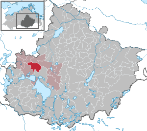
| Location of the municipality Grabowhöfe in the Mecklenburg Lake District | ||
  |
||

Grabowhöfe is a municipality in the Mecklenburg Lake District in Mecklenburg-Western Pomerania (Germany). It is administered by the Lake Landscape Department in Waren , based in the non-official city of Waren (Müritz) .
geography
Grabowhöfe is located between Mecklenburg Switzerland and the Mecklenburg Lake District . In the extreme north-west of the municipality is the deep lake and the southern tip of the flat lake .
Districts
- Baumgarten
- Grabowhöfe
- Louisenfeld
- Panschenhagen
- Summer peat
- Sophienhof
- Much is
history
Grabowhöfe was first mentioned in 1338 in a letter from Prince Nikolaus II von Werle as Grabow with 27 yards. The name Grabow comes from Slavic and means something like hornbeam town . In order to distinguish the place from other places called Grabow, it was called Grabowhöfe from the 18th century . After the Thirty Years' War , the village became the property of the von Hahn family after various changes of ownership . Around 1800, Count Friedrich von Hahn built a half-timbered manor house that still exists today. In 1886 the place received a train station. In the mid-1930s, parts of the property were sold to a settlement company and relocated. The remaining estate was after the land reform to new farmers awarded. In 1955 an LPG was established . The community was then developed into a central village and thereby received a large school and some prefabricated buildings.
Louisenfeld was first mentioned in the state calendar of Mecklenburg-Schwerin in 1878 .
Sommerstorf was first mentioned in a document in 1289. The village church dates from around 1300, the tower and the southern porch from the beginning of the 15th century.
Vielist was first mentioned in a document in 1264. The stone church dates from the beginning of the 13th century and received the tower top around 1700. The manor house dates from around 1789. In 2013, Vielist was incorporated into Grabowhöfe and the previous coat of arms of Vielist became the new municipal coat of arms of Grabowhöfe.
politics
coat of arms
|
|
Blazon : ". Under blue shield head where a herfliegendes silver glider in gold a red gear topped with a golden spike"
The coat of arms and the flag were designed by the Schwerin heraldist Heinz Kippnick . It was approved together with the flag on March 30, 2013 by the Ministry of the Interior and registered under the number 346 of the coat of arms of the state of Mecklenburg-Western Pomerania. |
|
Justification for the coat of arms: The coat of arms was designed in 2007, was approved by the Ministry of the Interior for the community of Vielist on March 30, 2007 and registered under the number 310 of the coat of arms of the state of Mecklenburg-Western Pomerania. This coat of arms was used as a national emblem by the incorporated community of Vielist until December 31, 2012. Thus, the coat of arms approved in 2007 initially lost its status as a national emblem on January 1, 2013 due to the incorporation. Since its symbolism and tinging are also representative for the receiving community and there is the possibility of continuing the former emblem of a commune that has merged into it, the previous emblem of Vielist became the new municipal coat of arms of Grabowhöfe.
In the coat of arms, the glider stands for the Waren / Vielist airfield built in 1966/67 and the sports aviation that has been operating there since then, as well as for the sightseeing flights that took place there. The cog wheel refers to the recent settlement of commercial companies, such as a steel construction company and companies in civil engineering and road construction. The ear of wheat refers to the traditional main occupation of the inhabitants, agriculture. |
flag

The flag is evenly striped lengthways in yellow and blue. In the middle of the flag is the municipal coat of arms, two thirds of the height of the yellow and blue stripes. The relation of the height of the flag cloth to the length is like 3: 5.
Official seal
The official seal shows the municipal coat of arms with the inscription "GEMEINDE GRABOWHÖFE • LANDKREIS MECKLENBURGISCHE SEENPLATTE".
Sights and culture
- Dorfkirche Sommerstorf : Gothic brick building from the second half of the 13th century.
- Vielister Church: field stone church from the 13th century
- Community hall Grabowhöfe as a cultural center
- Manor house Louisenfeld, brick building from 1870
- Panschenhage manor from around 1876, after 1989 Panschenhagen pottery
- Vielist Manor: Unrenovated, single-storey, 17-axis, red-stone-faced half-timbered building from 1789 onwards on very old cellars; Gable renovation from around 1850
- Bronze Age tumulus in Louisenfeld
- Early German tower hill from the 14th century in Louisenfeld
- Slavic ramparts from the 10th century near Grabowhöfe
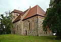
Church of Vielist

Vielist manor house


traffic
Grabowhöfe is on the Neustrelitz – Warnemünde railway line . There is a depot here, and passenger trains have not stopped here since 1999. The Waren / Vielist airfield is in the east of the municipality .
Web links
Individual evidence
- ↑ Statistisches Amt MV - population status of the districts, offices and municipalities 2019 (XLS file) (official population figures in the update of the 2011 census) ( help ).
- ↑ Hans-Heinz Schütt: On shield and flag production office TINUS, Schwerin 2011, ISBN 978-3-9814380-0-0 , p. 324/325.
- ↑ a b main statute § 2 (PDF).
Alt Schwerin | Altenhagen | Altenhof | Altentreptow | Ankershagen | Bartow | Basedow | Beggerow | Ownership | Blankenhof | Blankensee | Flower wood | Bollewick | Borrentine | Bredenfelde | Breesen | Breest | Briggow | Brunn | Buchholz | Stargard Castle | Burow | Bütow | Carpin | Cölpin | Dargun | Datzetal | Demmin | Eldetal | Rotten rust | Feldberger Seenlandschaft | Fincken | Friedland | Five lakes | Galenbeck | Gielow | Gnevkow | Godendorf | Goehren-Lebbin | Golchen | Gotthun | Grabowhöfe | Grammentin | Grapzow | Grischow | Large trowel | Groß Miltzow | Gross Nemerow | Large plastic | Groß Teetzleben | Grünow | Validity | Gülzow | High Wangelin | Hohenbollentin | Hohenmocker | Hohenzieritz | Holldorf | Ivenack | Jabel | Jürgenstorf | Kargow | Kentzlin | Kieve | Kittendorf | Little Thank You | Kletzin | Klink | Klocksin | Knorrendorf | Kratzeburg | Kriesow | Sublank | Kuckssee | Kummerow | Larz | Leizen | Lindenberg | Lindetal | Malchin | Malchow | Meesiger | Melz | Mirow | Möllenbeck | Möllenhagen | Mölln | Moltzow | Neddemin | Neetzka | Neubrandenburg | Neuenkirchen | Recalculation | Neustrelitz | Neverin | Nossendorf | Nossentiner Hut | Peenehagen | Penkow | Penzlin | Pragsdorf | Priborn | Priepert | Pripsleben | Rechlin | Ritzerow | Röbel / Müritz | Röckwitz | Rosenow | Sarov | Schloen-Dratow | Schönbeck | Schönfeld | Schönhausen | Black | Siedenbollentin | Siedenbrünzow | Sietow | Silz | Sommersdorf | Sponholz | Staven | Stavenhagen | Steer | Südmüritz | Torgelow am See | Trollenhagen | Tützpatz | Userin | Utzedel | Forgive | Voigtsdorf | Vollrathsruhe | Walow | Waren (Müritz) | Warrenzin | Werder | Wesenberg | Wildberg | Woggersin | Wokuhl-Dabelow | Wolde | Woldegk | Wulkenzin | Wustrow | Zettemin | Zirzow | Zislow