
Kratzeburg
| coat of arms | Germany map | |
|---|---|---|

|
Coordinates: 53 ° 26 ' N , 12 ° 56' E |
|
| Basic data | ||
| State : | Mecklenburg-Western Pomerania | |
| County : | Mecklenburg Lake District | |
| Office : | Neustrelitz-Land | |
| Height : | 68 m above sea level NHN | |
| Area : | 54.66 km 2 | |
| Residents: | 526 (Dec. 31, 2019) | |
| Population density : | 10 inhabitants per km 2 | |
| Postal code : | 17237 | |
| Area code : | 039822 | |
| License plate : | MSE, AT, DM, MC, MST, MÜR, NZ, RM, WRN | |
| Community key : | 13 0 71 080 | |
| Office administration address: | Marienstraße 5 17235 Neustrelitz |
|
| Website : | ||
| Mayor : | Guntram Wagner | |
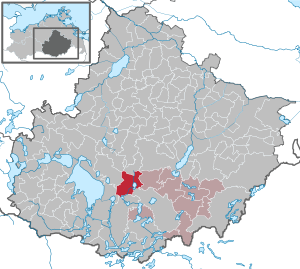
| Location of the municipality of Kratzeburg in the Mecklenburg Lake District | ||
  |
||

Kratzeburg is a municipality in the Mecklenburg Lake District in southern Mecklenburg-Western Pomerania . It is administered by the Neustrelitz-Land Office , based in the non-official city of Neustrelitz .
geography
The municipality of Kratzeburg, which is very rich in lakes and forests, is located in the western part of the Müritz National Park , which extends from Waren (Müritz) to the western urban area of Neustrelitz. The Havel rises north of the municipality near Ankershagen . It flows as a small trickle through several lakes, such as the 2.4 km² Käbelicksee , in a southerly direction. The Havel leaves the municipality at the district of Krienke. The Obere Havel water hiking route begins in Kratzeburg . To the southeast of the Pieverstorf district are up to 105 m above sea level. NHN high Pieverstorfer mountains .
Kratzeburg is surrounded by the neighboring communities Ankershagen in the north, Penzlin in the northeast, Klein Many in the east, Neustrelitz in the southeast, Mirow in the south, Rechlin in the southwest, Kargow in the west and Schloen-Dratow in the northwest.
The districts of Dalmsdorf , Dambeck , Granzin , Krienke and Pieverstorf belong to Kratzeburg .
history
The castle wall south of Pieverstorf on the east bank of the Dambeck lake dates from the Bronze Age . It is one of the largest facilities of that time. The Slavic castle of Kratzeburg (castrum Zcarnitz), mentioned in a document in 1170, is located 350 meters southwest of the Bronze Age castle ramparts on a hill. In the town of Kratzeburg, the Schloßberg is evidence of medieval settlement. A knight's castle of the lower nobility stood here in the 14th to 15th centuries on the artificially constructed tower hill Kratzeburg .
The lake bottom is clearly visible north of Kratzeburg to Diekenbruch south of the Havel spring. These hills in the forest, which are no longer suitable for agricultural use because the soil is too compact, are candidates for the as yet unrecognized settlements of the megalithic culture , of which only the graves are known so far.
From 1701 to 1918 the area of Kratzeburg belonged to the (Grand) Duchy of Mecklenburg-Strelitz .
On January 1, 1951, the previously independent municipality of Dambeck was incorporated.
politics
Coat of arms, flag, official seal
The municipality has no officially approved national emblem, neither a coat of arms nor a flag. The official seal is the small state seal with the coat of arms of the state of Mecklenburg. It shows a looking bull's head with torn off the neck fur and crown and the inscription "GEMEINDE KRATZEBURG * LANDKREIS MECKLENBURGISCHE SEENPLATTE".
Sights and culture
Buildings
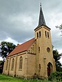
- Half-timbered church in Kratzeburg - An old altar on the side wall has a carving after 1450. The sides show the court hearing, the Judas kiss, the Stations of the Cross and Jesus praying. Inside: the crucifixion scene. In the corners we find four saints. This altar was brought to Schillersdorf during the Thirty Years War (1640) and did not return to Kratzeburg until 1935. It has a remarkable design parallel to the altar of the Fabian and Sebastian Church in Beverstedt .
- Brick church in Granzin
- Glass factory in Dalmsdorf

Church in Kratzeburg

Altar from 1450 in the Kratzeburg Church
Church in Granzin


_Kirche_2010-09-03_227.JPG)
Regular events
The JugendMedienCamp takes place every year at Whitsun on the campsite in Kratzeburg.
Transport links
From the federal highway 193 , about halfway between Neustrelitz and Penzlin , you can reach Kratzeburg on an approximately seven kilometer long connecting road.
Kratzeburg is in close proximity to the Neustrelitz – Rostock railway line . There is a train station in the village, which regional trains stop at every two hours. Other transport options are the buses of MVVG .
literature
Web links
Individual evidence
- ↑ Statistisches Amt MV - population status of the districts, offices and municipalities 2019 (XLS file) (official population figures in the update of the 2011 census) ( help ).
- ↑ Main Statute, Section 1, Paragraph 2
- ^ Church MV ( Memento from October 6, 2012 in the Internet Archive )
- ^ Description of the "old church" in Beverstedt
- ^ Annual youth media camp in Kratzeburg
Alt Schwerin | Altenhagen | Altenhof | Altentreptow | Ankershagen | Bartow | Basedow | Beggerow | Ownership | Blankenhof | Blankensee | Flower wood | Bollewick | Borrentine | Bredenfelde | Breesen | Breest | Briggow | Brunn | Buchholz | Stargard Castle | Burow | Bütow | Carpin | Cölpin | Dargun | Datzetal | Demmin | Eldetal | Rotten rust | Feldberger Seenlandschaft | Fincken | Friedland | Five lakes | Galenbeck | Gielow | Gnevkow | Godendorf | Goehren-Lebbin | Golchen | Gotthun | Grabowhöfe | Grammentin | Grapzow | Grischow | Large trowel | Groß Miltzow | Gross Nemerow | Large plastic | Groß Teetzleben | Grünow | Validity | Gülzow | High Wangelin | Hohenbollentin | Hohenmocker | Hohenzieritz | Holldorf | Ivenack | Jabel | Jürgenstorf | Kargow | Kentzlin | Kieve | Kittendorf | Little Thank You | Kletzin | Klink | Klocksin | Knorrendorf | Kratzeburg | Kriesow | Sublank | Kuckssee | Kummerow | Larz | Leizen | Lindenberg | Lindetal | Malchin | Malchow | Meesiger | Melz | Mirow | Möllenbeck | Möllenhagen | Mölln | Moltzow | Neddemin | Neetzka | Neubrandenburg | Neuenkirchen | Recalculation | Neustrelitz | Neverin | Nossendorf | Nossentiner Hut | Peenehagen | Penkow | Penzlin | Pragsdorf | Priborn | Priepert | Pripsleben | Rechlin | Ritzerow | Röbel / Müritz | Röckwitz | Rosenow | Sarov | Schloen-Dratow | Schönbeck | Schönfeld | Schönhausen | Black | Siedenbollentin | Siedenbrünzow | Sietow | Silz | Sommersdorf | Sponholz | Staven | Stavenhagen | Steer | Südmüritz | Torgelow am See | Trollenhagen | Tützpatz | Userin | Utzedel | Forgive | Voigtsdorf | Vollrathsruhe | Walow | Waren (Müritz) | Warrenzin | Werder | Wesenberg | Wildberg | Woggersin | Wokuhl-Dabelow | Wolde | Woldegk | Wulkenzin | Wustrow | Zettemin | Zirzow | Zislow